SUMMARY
This is AI generated summarization, which may have errors. For context, always refer to the full article.
MANILA, Philippines – The United States Navy’s Joint Typhoon Warning Center (JTWC) said Ruby (international name: Hagupit) is back to super typhoon status as of Friday evening, December 5, as the Philippines’ own weather bureau hoisted Storm Signal No. 3 over the Samar provinces.
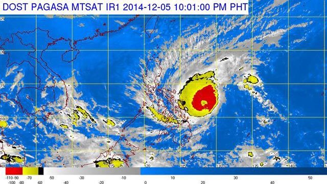
State weather bureau PAGASA, however, maintained the typhoon status of Ruby in its 11 pm bulletin. Located 305 kilometers east of Borongan, Eastern Samar, as of 10 pm, the typhoon packed maximum sustained winds of 195 km/h near the center and gusts of up to 230 km/h.
Ruby as recorded by PAGASA was slightly weaker and slower than Japan Meteorological Agency’s data of wind speed of 198 km/h near the center and wind gust speed of 270 km/h. The Japanese agency labeled Ruby as “violent.”
The JTWC, for its part, recorded a stronger maximum sustained winds of 130 KT (240.76 km/h) and gustiness of 160 KT (296.32 km/h) for Ruby.
PAGASA earlier said it might raise the public storm warning to Signal Number 4 once the typhoon hits land, but said it will only be done within 12 hours of the predicted landfall on Saturday evening, December 6.
Aside from the 3 Samar provinces being placed under Signal No. 3, 11 provinces are under Signal No. 2, while 20 are under Signal No. 1 as of late Friday evening.

Public storm warning signals have been raised over the following areas:
| Signal no. 3 (Winds of 101 to 185 km/h in at least 18 hours) |
Signal no. 2 (Winds of 61 to 100 km/h in at least 24 hours) |
Signal no. 1 (Winds of 30-60 kph in at least 36 hours) |
| Northern Samar | Catanduanes | Camarines Norte |
| Eastern Samar | Albay | Camarines Sur |
| Samar | Sorsogon | Burias Island |
| Masbate including Ticao Island | Romblon | |
| Biliran | Southern Quezon | |
| Leyte | Marinduque | |
| Southern Leyte | Capiz | |
| Northern Cebu including Cebu City | Iloilo | |
| Bantayan Island | Antique | |
| Camotes Island | Guimaras | |
| Dinagat Province | Aklan | |
| Negros Oriental | ||
| Negros Occidental | ||
| Rest of Cebu | ||
| Bohol | ||
| Surigao del Sur | ||
| Surigao del Norte including Siargao Island | ||
| Agusan del Norte | ||
| Agusan del Sur | ||
| Camiguin |
PAGASA warned residents in low lying and mountainous areas against flashfloods and landslides.
For areas under signal number 3, residents along the coast are warned on the occurrence of big waves associated with Storm Surge which may reach up to 4 meters.
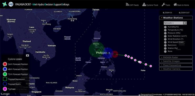
Ruby has slowed down a bit, moving toward the west at a speed of 10 km/h. PAGASA said landfall is forecast in the area of Eastern Samar and Northern Samar by Saturday evening, December 6, or early Sunday, December 7.
Heavy to intense rainfall (7.5-20 mm/h) is expected within the typhoon’s 600 kilometer diameter.
PAGASA earlier identified 47 provinces as “potential high-risk areas” that are likely to be affected by the typhoon’s 600 kilometer diameter.
It is expected to exit the Philippine Area of Responsibility (PAR) by Wednesday morning, December 10.
“Monsoon will bring rough to very rough sea conditions over the seaboards of Northern Luzon, eastern seaboard of Central and Southern Luzon, seaboards of Visayas and over northern and eastern seaboards of Mindanao,” the bureau said in its severe weather bulletin.
The next bulletin will be released at 5 am Saturday. – Rappler.com
Add a comment
How does this make you feel?
There are no comments yet. Add your comment to start the conversation.