SUMMARY
This is AI generated summarization, which may have errors. For context, always refer to the full article.
What’s the weather like in your area? Tweet us the situation: Use #weatheralert and tag @rapplerdotcom
MANILA, Philippines (UPDATED) – State weather bureau PAGASA has raised public storm warning signal number 3 over Cagayan, Isabela, and Northern Aurora as Typhoon Dodong (international name: Noul) has maintained its strength late Saturday morning, May 9.
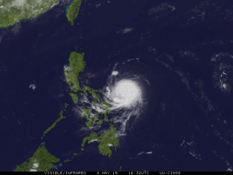
As of 10 am Saturday, the typhoon was located at 210 km northeast of Virac, Catanduanes or 460 km east of Infanta, Quezon. It packs maximum sustained winds of 160 km/h near the center and gustiness of up to 195 km/h.
The typhoon is still moving west northwest in direction at 20 km/h, with heavy to intense rainfall estimated within its 200-km diameter.
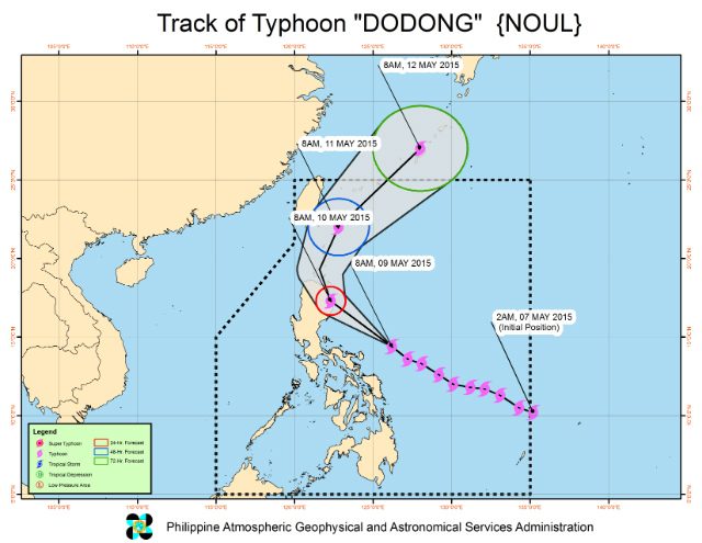
Dodong is expected to make landfall over the coast of Isabela-Cagayan area by Sunday early morning, May 10.
PAGASA said the typhoon will exit the landmass via Aparri, Cagayan by Sunday afternoon, and will leave the Philippine Area of Responsibility by Monday evening, May 11.
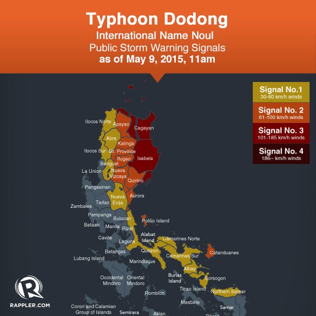
The provinces of Cagayan, Isabela, and Northern Aurora are now under public storm warning signal number 3, with winds of 121 km/h to 170 km/h expected in at least 18 hours.
At least 11 areas are also under public storm warning signal number 2:
- Calayan Group of Island
- Babuyan Group of Island
- Apayao
- Kalinga
- Mt Province
- Nueva Vizcaya
- Ifugao
- Rest of Aurora
- Polillo Island
- Catanduanes
- Qurino
Public storm warning signal number 1 is raised over 12 areas:
- Batanes
- Abra
- Ilocos Sur
- Ilocos Norte
- Benguet
- Nueva Ecija
- Quezon
- Camarines Norte
- Camarines Sur
- Albay
- Sorsogon
- Northern Samar
The bureau warned against possible storm surges of up to 2.5 meters over the eastern coast of Camarines Sur, Quezon and Isabela.
“It is advised to refrain from outdoor activities particularly along beaches of the eastern section of Luzon starting today (May 9) until tomorrow (May10),” PAGASA said in its 11 am Saturday bulletin.
Residents in low lying and mountainous areas under storm signals must also stay alert against possible flashfloods and landslides, while fisherfolks are advised against venturing out over the eastern seaboard of Visayas.
Meanwhile, independent weather monitoring group Weather Philippines said in its 7:30 am Saturday bulletin that the typhoon will potentially hit land “along the eastern shores of Isabela or Cagayan” Sunday early afternoon – a little later than PAGASA’s prediction.
The group’s Advance Intensity Forecast also showed that by Sunday early morning, Dodong’s 10-minute maximum sustained winds could increase up to 205 km/h.
The Japan Meteorological Agency now classifies Dodong as a “very strong” typhoon.
The next bulletin on Dodong will be issued at 5 pm Saturday. – Rappler.com
Add a comment
How does this make you feel?
There are no comments yet. Add your comment to start the conversation.