SUMMARY
This is AI generated summarization, which may have errors. For context, always refer to the full article.
What’s the weather like in your area? Tweet us the situation: Use #weatheralert and tag @rapplerdotcom
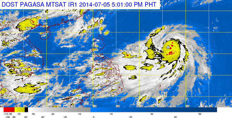
MANILA, Philippines – The skies will be cloudy in Visayas and parts of Luzon on Sunday, July 6, as a strong typhoon is expected to enter the Philippine Area of Responsibility (PAR), said the state weather bureau PAGASA in its 24-hour weather bulletin on Saturday, July 5.
Typhoon Neoguri was spotted 1,360 kms east of Casiguran, Aurora, at 4 pm Saturday. It is moving northwest at 25 km/h, with maximum sustained winds of 150 km/h and gustiness of up to 185 km/h.
In its 10 am weather advisory on Saturday, PAGASA said that Neoguri is expected to enter PAR by early Sunday morning. Once it does so, the typhoon will be given the name Florita.
Weather Philippines, however, forecasts that the typhoon is headed toward the Ryukyu Islands between Taiwan and southern Japan, and would not be a threat to the Philippines. (Data from Weather Philippines is not official data. Official weather information is issued by state weather bureau PAGASA.)
PAGASA advised the public and local disaster risk reduction and management councils to be on alert. Updates about typhoon Neoguri will be posted on PAGASA’s next weather bulletin on Sunday morning.
The Bicol and Mimaropa regions, as well as the Visayas, will experience cloudy skies with light to moderate rains and thunderstorms.
Meanwhile, Metro Manila and the rest of the country will have partly cloudy to cloudy skies with isolated rainshowers or thunderstorms.
Coastal waters will be moderate to rough, as moderate to strong winds blow from the southwest to west over Southern Luzon, Visayas, and Mindanao. Over the rest of the country, light to moderate winds coming from the southwest will prevail.
| City | Forecast | Temperature Range |
|
| Metro Manila |  |
Partly cloudy to at times cloudy with rainshowers and/or thunderstorms |
25°C-32°C |
| Tuguegarao | |
Partly cloudy to at times cloudy with rainshowers and/or thunderstorms |
25°C-34°C |
| Laoag | |
Partly cloudy to at times cloudy with rainshowers and/or thunderstorms |
25°C-32°C |
| Baguio | |
Partly cloudy to at times cloudy with rainshowers and/or thunderstorms |
16°C-23°C |
| Subic/Olongapo; Clark/Angeles | |
Partly cloudy to at times cloudy with rainshowers and/or thunderstorms |
25°C-31°C |
| Tagaytay | |
Partly cloudy to at times cloudy with rainshowers and/or thunderstorms |
22°C-31°C |
| Lipa | |
Partly cloudy to at times cloudy with rainshowers and/or thunderstorms |
24°C-32°C |
| Legazpi |  |
Cloudy skies with rainshowers and/or thunderstorms |
25°C-32°C |
| Puerto Princesa | |
Cloudy skies with rainshowers and/or thunderstorms |
25°C-30°C |
| Iloilo/Bacolod | |
Cloudy skies with rainshowers and/or thunderstorms |
23°C-30°C |
| Metro Cebu | |
Cloudy skies with rainshowers and/or thunderstorms |
25°C-30°C |
| Tacloban | |
Cloudy skies with rainshowers and/or thunderstorms |
24°C-31°C |
| Cagayan de Oro | |
Partly cloudy to at times cloudy with rainshowers and/or thunderstorms |
24°C-31°C |
| Metro Davao | |
Partly cloudy to at times cloudy with rainshowers and/or thunderstorms |
25°C-33°C |
| Zamboanga | |
Partly cloudy to at times cloudy with rainshowers and/or thunderstorms |
25°C-33°C |
– Rappler.com
Add a comment
How does this make you feel?
![[In This Economy] Is the Philippines quietly getting richer?](https://www.rappler.com/tachyon/2024/04/20240426-Philippines-quietly-getting-richer.jpg?resize=257%2C257&crop=194px%2C0px%2C720px%2C720px)
![[In This Economy] A counter-rejoinder in the economic charter change debate](https://www.rappler.com/tachyon/2024/04/TL-counter-rejoinder-apr-20-2024.jpg?resize=257%2C257&crop=267px%2C0px%2C720px%2C720px)
![[Vantage Point] Joey Salceda says 8% GDP growth attainable](https://www.rappler.com/tachyon/2024/04/tl-salceda-gdp-growth-04192024.jpg?resize=257%2C257&crop_strategy=attention)
![[ANALYSIS] A new advocacy in race to financial literacy](https://www.rappler.com/tachyon/2024/04/advocacy-race-financial-literacy-April-19-2024.jpg?resize=257%2C257&crop_strategy=attention)

There are no comments yet. Add your comment to start the conversation.