SUMMARY
This is AI generated summarization, which may have errors. For context, always refer to the full article.
What’s the weather like in your area? Tweet us the situation: Use #weatheralert and tag @rapplerdotcom
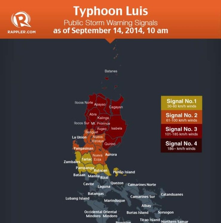
MANILA, Philippines (UPDATED) – Eleven areas were placed under public storm warning signal number 3 on Sunday morning, September 14, as Typhoon Luis (Kalmaegi) gained strength approaching northeastern Luzon.
Luis is expected to make landfall over Cagayan or Isabela late Sunday afternoon or early evening.
At 10 am Sunday, the typhoon was spotted 213 km East of Casiguran, Aurora. It had maximum winds of 130 kilometers per hour (kph) and gustiness of up to 160 kph. It is forecast to move west northwest at 20 kph, state weather bureau Pagasa said in its 11 am bulletin.
Pagasa placed 11 areas under storm signal number 3 (winds of 101-185 kph expected in at least 18 hours). These areas include:
- Cagayan including Babuyan and Calayan Group of Islands
- Apayao
- Ilocos Norte
- Abra
- Kalinga
- Isabela
- Mt. Province
- Ilocos Sur
- Ifugao
- Northern Aurora
- Quirino
Seven areas were placed under public storm signal warning number 2 (winds of 61-100 kph expected in at least 24 hours):
-
Batanes Group of Islands
-
La Union
-
Benguet
-
Nueva Vizcaya
-
Pangasinan
-
Nueva Ecija
-
The rest of Aurora
Six areas were placed under public storm signal warning number 1 (winds of 30 – 60 kph expected in at least 36 hours):
-
Tarlac
-
Zambales
-
Pampanga
-
Bulacan
-
Northern Quezon
-
Pollilo Island
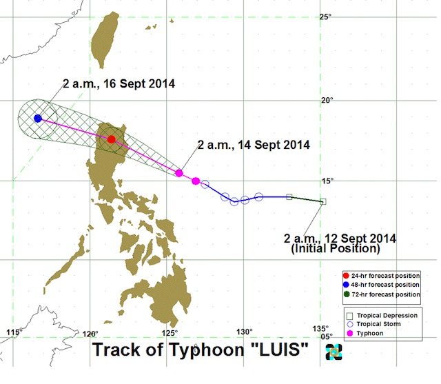
Luis is expected to exit Ilocos Norte Monday morning, September 15. It will be out of the Philippine area of responsibility by Tuesday morning, September 16, according to Pagasa.
Pagasa warned against possible flashfoods, landslides, and storm surges of up to 2 meters.
Estimated rainfall amount is from 8 – 20 millimeters per hour (heavy – Intense) within the 500 km diameter of the Typhoon.
Pagasa said the combined effect of the typhoon and the Southwest Monsoon will bring moderate to occassionally heavy rains and thunderstorms – possibly triggering flashfloods and landslides – would be experienced in Bicol Region, Quezon and the rest of Central Luzon.
Light to moderate rains and thunderstorms will be experienced over Metro Manila and the rest of Luzon and Visayas.
“Fishing boats and other small seacrafts are advised not to venture out into the seaboards of Visayas and the eastern seaboard of Southern Luzon and of Mindanao,” Pagasa said. – Rappler.com
Stay alert and ready with the latest weather and disaster information through Project Agos.
Add a comment
How does this make you feel?
There are no comments yet. Add your comment to start the conversation.