SUMMARY
This is AI generated summarization, which may have errors. For context, always refer to the full article.
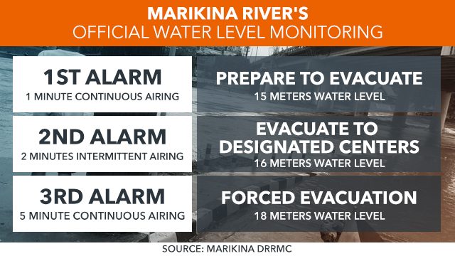
Marikina City has a 3-stage alarm level system for the Marikina River, with corresponding actions to be taken per level
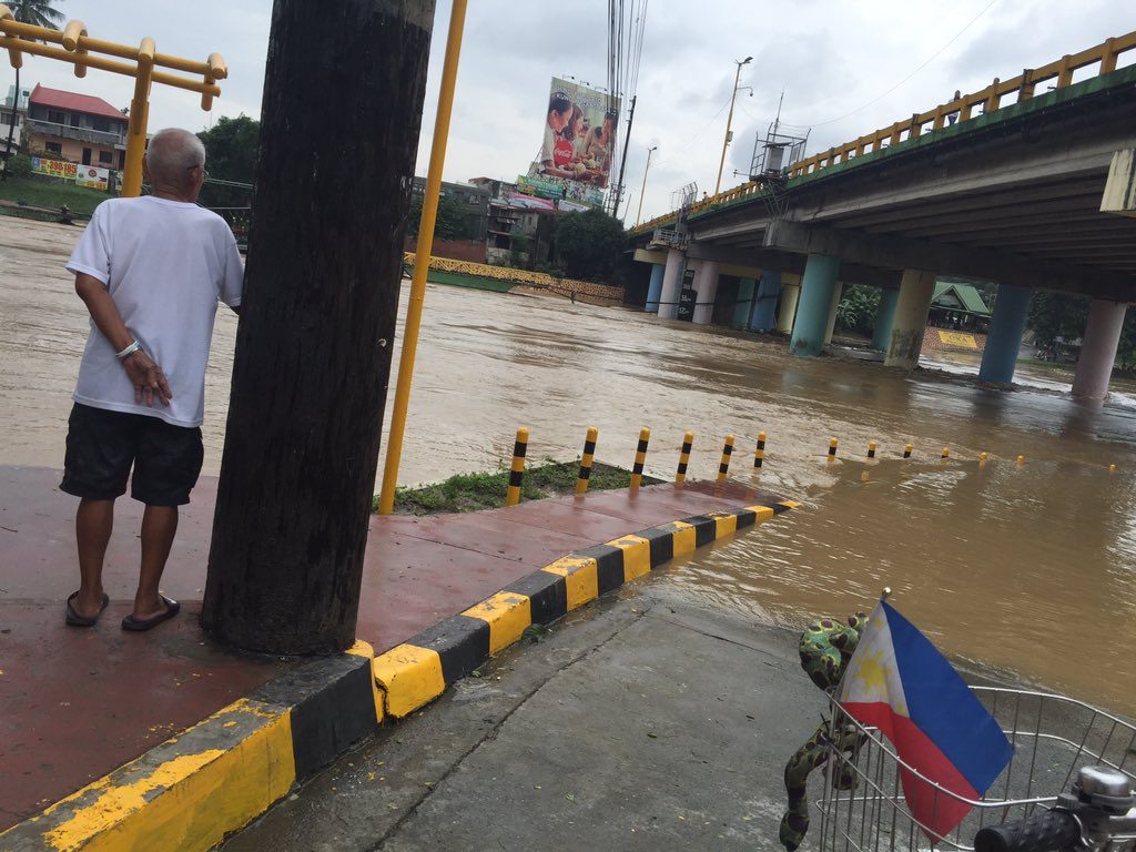
MANILA, Philippines – Whenever heavy rain hits Metro Manila, the water level along the Marikina River is one of the things being closely monitored by local officials.
In the past, the bursting of the river banks not only caused massive flooding in Marikina City and other parts of Metro Manila but also displaced hundreds of families living near the river.
“Kapag umuulan, ‘yung water from Marikina River bumabagsak sa Pasig River at Laguna de Bay. Kung bumabaha sa Marikina River, babagsak ‘yan sa kalakhang Maynila,” explained Jun Bautista from the flood control office of the Metropolitan Manila Development Authority (MMDA).
(When it rains, the water from the Marikina River flows to the Pasig River and Laguna de Bay. When areas around the Marikina River experience flooding, the floodwaters also flow to other parts of Metro Manila.)
To prevent heavy flooding in Metro Manila, Bautista said the MMDA would directly divert water to the Laguna de Bay through the Manggahan Floodway.
Marikina City has a 3-stage alarm level system for the Marikina River, based on the depth of water in the river below the Sto. Niño Bridge:
 Monitoring
To forecast and monitor flooding, the local disaster risk reduction and management (DRRM) office in Marikina has installed at least two water level monitoring equipment along the Marikina River.
The river monitoring sensors from the Department of Science and Technology are installed at Tumana Bridge and Sto. Niño Bridge. These sensors are able to “accurately measure and determine the floodwaters in real time.”
When the river’s water level rises, the local DRRM office in Marikina uses a siren to alert surrounding communities of the current alarm level.
According to Marikina City’s public information office, the towns of Malanday, Nangka, and Tumana are considered critical areas.
The 27-kilometer river connects to a number of tributary waterways which drain into 4 municipalities and one city in Rizal province, and 3 cities in Metro Manila. – Rappler.com
Monitoring
To forecast and monitor flooding, the local disaster risk reduction and management (DRRM) office in Marikina has installed at least two water level monitoring equipment along the Marikina River.
The river monitoring sensors from the Department of Science and Technology are installed at Tumana Bridge and Sto. Niño Bridge. These sensors are able to “accurately measure and determine the floodwaters in real time.”
When the river’s water level rises, the local DRRM office in Marikina uses a siren to alert surrounding communities of the current alarm level.
According to Marikina City’s public information office, the towns of Malanday, Nangka, and Tumana are considered critical areas.
The 27-kilometer river connects to a number of tributary waterways which drain into 4 municipalities and one city in Rizal province, and 3 cities in Metro Manila. – Rappler.com
- Alarm Level 1: when the water is 15 meters above sea level, means “prepare”
- Alarm Level 2: when the water is 16 meters above sea level, means “evacuate”
- Alarm Level 3: when the water is 18 meters above sea level, means “forced evacuation”
Monitoring
To forecast and monitor flooding, the local disaster risk reduction and management (DRRM) office in Marikina has installed at least two water level monitoring equipment along the Marikina River.
The river monitoring sensors from the Department of Science and Technology are installed at Tumana Bridge and Sto. Niño Bridge. These sensors are able to “accurately measure and determine the floodwaters in real time.”
When the river’s water level rises, the local DRRM office in Marikina uses a siren to alert surrounding communities of the current alarm level.
According to Marikina City’s public information office, the towns of Malanday, Nangka, and Tumana are considered critical areas.
The 27-kilometer river connects to a number of tributary waterways which drain into 4 municipalities and one city in Rizal province, and 3 cities in Metro Manila. – Rappler.com Add a comment
How does this make you feel?
Loading
There are no comments yet. Add your comment to start the conversation.