SUMMARY
This is AI generated summarization, which may have errors. For context, always refer to the full article.
MANILA, Philippines (2nd UPDATE) – Typhoon “Pablo”accelerated after entering the Philippine Area of Responsibility (PAR) and storm signal #1 was raised over 18 provinces in Mindanao and Visayas on Sunday, December 2.
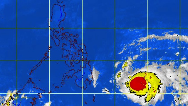
In its 11 pm bulletin, weather bureau PAGASA announced that as of 10pm Pablo (international codename: Bopha) was located 810 kilometers (km) Southeast of Hinatuan, Surigao del Sur (6.4°N, 134.0°E).
The typhoon is packing maximum sustained winds of 185 km per hour and gusts of up to 220 km/h, and moving west northwest at 26 km/h.
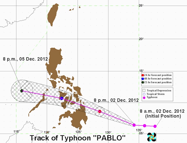
PAGASA chief weather forecaster Robert Sawi earlier said that Pablo would make landfall in northern Mindanao or eastern Visayas Tuesday, December 4.
Mindanao, Visayas to be hit
Pablo is forecast to pass through central Visayas toward Panay, then northern Palawan and Mindoro before exiting the country into the South China Sea (West Philippine Sea).
Heavy to intense rainfall (20-30 millimeters per hour) is expected within the typhoon’s 700 km diameter, and large parts of Mindanao and Visayas should prepare for floods and landslides.
Public storm signal warning #1 (45-60 km/h winds in the next 36 hours) is in place over 18 provinces in Mindanao and Visayas:
- Surigao del Sur
- Surigao del Norte including Siargao Island
- Dinagat Island
- Agusan del Norte
- Agusan del Sur
- Davao Oriental
- Davao del Norte inluding Samal Island
- Compostela Valley
- Bukidnon
- Misamis Oriental
- Camiguin
- Bohol
- Biliran
- Camotes Island
- Southern Leyte
- Leyte
- Eastern Samar
- Western Samar
By Monday evening, Pablo will be 235 km East of Hinatuan and is expected to make landfall before noon on Tuesday over the northern portion of Surigao del Sur.
The typhoon will then travel to the Bohol, Cebu, Negros and Panay, and by Tuesday evening will be in the vicinity of Iloilo.
Pablo is forecast to continue moving toward Busuanga (northern Palawan) on Wednesday and on early Thursday morning will exit the PAR unless it makes a U-turn and approaches Luzon.
The typhoon is being closely monitored by foreign weather bureaus: US Navy’s Joint Typhoon Warning Center classified Pablo as a “super typhoon”, while the Japan Meteorological Agency said it was a “very strong” storm.
Citizens must be ready
National Disaster Risk Reduction and Management Council (NDRRMC) executive director Benito Ramos appealed to citizens, especially those along the path of the typhoon, to heed warnings as early as now.
“Do not wait for your LGUs [to warn you],” Ramos said during a press conference at the PAGASA headquarters in Quezon City.
He also implored fishermen in the affected areas to avoid going out to sea in the next few days to avoid the strong waves and winds brought by the typhoon.
The Philippine Coast Guard (PCG) advised operators of small vessels and fishing boats to avoid the southeastern and eastern sections of the country, where the sea will be “rough.”
In a message posted on the PCG website, officer-in-charge Rear Admiral Luis Tuason Jr. pointed out that sea travel even in areas not affected by Pablo may not be safe.
Tuason stressed that any seacraft will not be allowed to sail in areas under public storm signals, when these are issued by PAGASA.
Strongest storm of 2012
Pablo is the 16th and probably the last typhoon to affect the Philippines in 2012, but it may also be the strongest to hit the country this year.
“This is a powerful storm, perhaps the strongest this year, and we enjoin everyone to take precautionary measures,” Ramos told AFP.
The NDRRMC chief said local governments in the areas likely to be soaked by heavy rains had been advised to undertake precautionary evacuations if needed, though none has been ordered so far.
Nearly 100 people died and more than a million were displaced in August by the Habagat floods in Metro Manila and other parts of Luzon.
A total of 19 typhoons struck the Philippines last year, leading to more than 1,500 deaths and affecting nearly 10 percent of the total population, according to the government.
The worst calamity was tropical storm “Sendong” in December 2011. – Rappler.com, with reports from Agence France-Presse
Add a comment
How does this make you feel?
There are no comments yet. Add your comment to start the conversation.