SUMMARY
This is AI generated summarization, which may have errors. For context, always refer to the full article.
MANILA, Philippines – Typhoon “Pablo” maintained its strength and is now threatening Davao Oriental as well as Surigao, while public storm warning signal #3 was raised over 5 more high-risk areas on Monday, December 3.
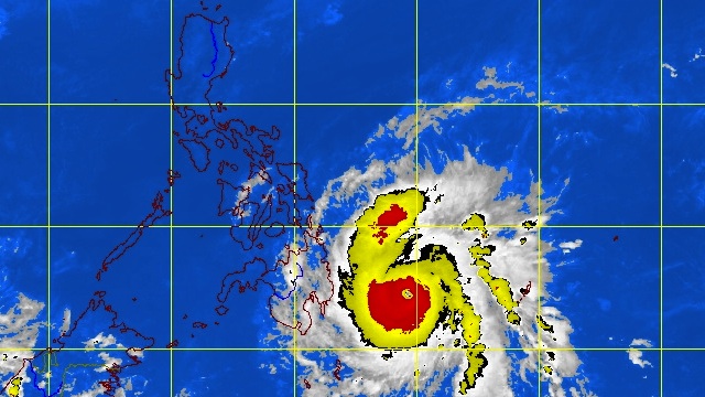
In its 5pm bulletin, weather bureau PAGASA noted that as of 4pm “Pablo” was located 390 km Southeast of Hinatuan, Surigao del Sur (07.1°N, 129.9°E).
The typhoon is packing maximum sustained winds of 175 km/h and gusts of up to 210 km/h, and moving West at 26 km/h.
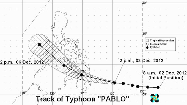
By Tuesday afternoon, Pablo will be in the vicinity of Cagayan de Oro, while a day later the weather disturbance is expected to be 110 km Southwest of Iloilo City, and 330 km West of Calapan, Oriental Mindoro by Thursday afternoon.
Storm signals over most of Mindanao, Visayas
PAGASA has raised storm signal #3 (101-185 km/h winds) over the following areas:
- Surigao del Norte including Siargao
- Surigao del Sur
- Dinagat
- Agusan del Norte
- Agusan del Sur
- Misamis Oriental
- Bukidnon
- Davao Oriental
- Compostela Valley
- Davao del Norte including Samal Island
Storm signal #2 (61-100 km/h winds) is in place for:
- Southern Leyte
- Bohol
- Southern Cebu
- Negros Oriental
- Siquijor
- Misamis Occidental
- Lanao del Norte
- Lanao del Sur
- North Cotabato
- Zamboanga del Norte
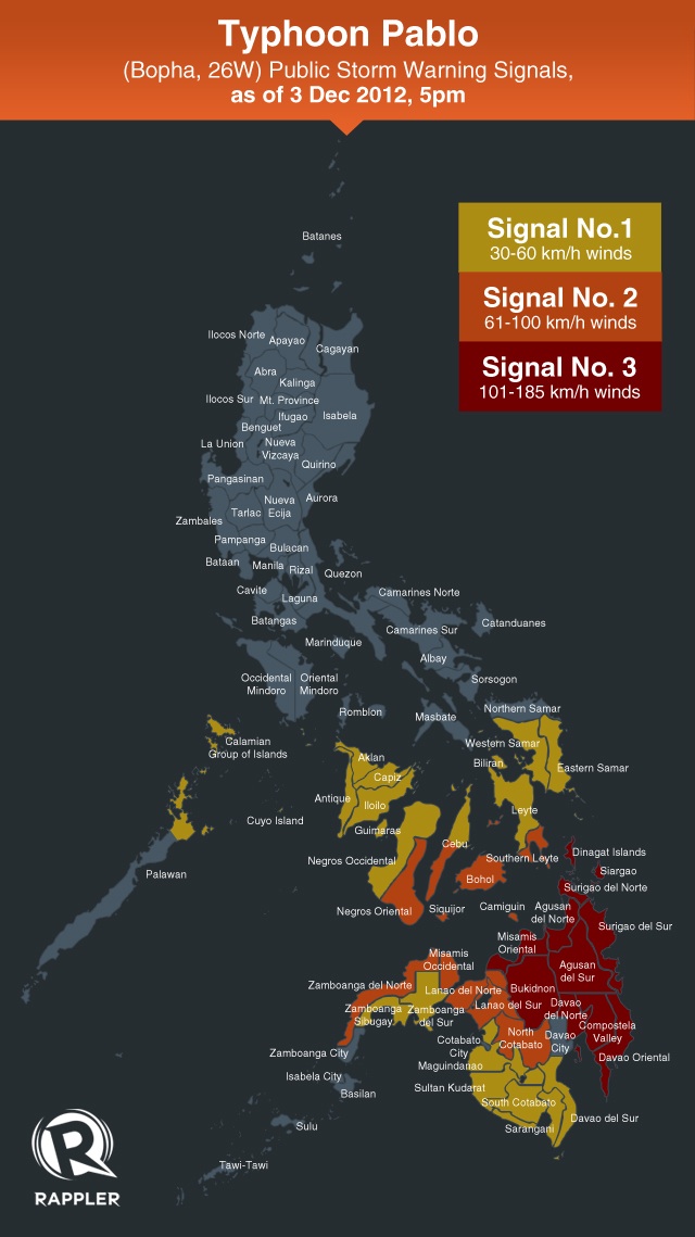
Finally, the weather bureau hoisted storm signal #1 (45-60 km/h winds) over:
- Northern Palawan including the Calamian group of islands and Cuyo Island
- Eastern Samar
- Western Samar
- Leyte including Biliran
- Aklan
- Capiz
- Antique
- Iloilo
- Guimaras
- Negros Occidental
- Cebu including Camotes Island
- Zamboanga del Sur
- Maguindanao
- Sultan Kudarat
- Sarangani
- South Cotabato
Big waves, storm surges
The estimated rainfall within the 600 km diameter of the typhoon is 15-30 mm/h (heavy-intense) and residents living in low-lying and mountainous areas in affected regions are alerted against possible flash floods and landslides.
PAGASA warned people in coastal areas under storm signals #3 and #2 to expect big waves and storm surges generated by “Pablo.”
Fishing boats and other small vessels should not venture out in the eastern seaboards of Mindanao and Visayas. – Rappler.com
Add a comment
How does this make you feel?
There are no comments yet. Add your comment to start the conversation.