SUMMARY
This is AI generated summarization, which may have errors. For context, always refer to the full article.

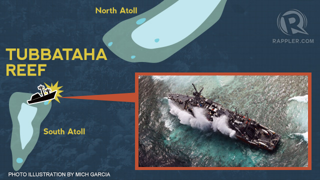
MANILA, Philippines – The US minesweper that ran aground on Tubbataha Reef Natural Park now has “multiple spaces” flooded on board, a US Navy publication said on Monday, January 21.
“Weather conditions remain rough, and the ship, once pointed straight into the reef with her bow hard aground, has swung broadside on, where most of the starboard hull is in contact with the coral,” according to an article published by the Navy Times newsletter.
At least 17 m of the hull have already penetrated the reef after the vessel turned 90 degrees due to the strong currents and winds.
On Saturday night, the USS Guardian experienced a “slight increase to a port list” and commanding officer Lt Cmdr Mark Rice is concerned that the ship may sustain further damage.
The crew was evacuated but the ship has “not been abandoned,” the US Pacific Fleet said.
The same publication noted that the digital mapping system misplaced the location of the reef by about 8 nautical miles, and that “may have been a significant factor” that led to the crash.
US Navy ships have now been ordered to “operate with caution” when using similar electronic charts and compare the data with paper maps considered more accurate, the Navy Times said.
Aerial surveys conducted by American air craft indicate that there are no fuel leaks, but “the hull continues to be battered, particularly on the port side.”
.jpg)
Faulty digital maps
The US Navy on Saturday suggested that faulty navigation charts may have caused the accident.
According to the Navy Times, the Digital Nautical Charts (DNC) produced by the National Geospatial-Intelligence Agency (NGA) come in two different versions:
- “General” and “coastal” versions used in open areas such as the Sulu Sea
- “Approach” and “harbor” for operating in and around harbors
The Navy Times said the error was in the “coastal” DNC, as the general and hard copy charts show the reef’s location correctly.
NGA director Letitia Long told the US Navy that the faulty charts should be corrected by January 30 and advised vessels to not travel through the area until then.
US Navy head navigator Rear Adm Jonathan White urged all ships to observe extreme caution when operating when NGA-supplied digital mapping “due to an identified error in the accuracy of charting in the Sulu Sea.”
White nevertheless insisted that an probe into the accident is still ongoing.
“This guidance to the fleet does not presuppose the cause of the USS Guardian grounding (…) The investigation will look at a number of potential contributing factors,” the official said.
The US Navy apologized for the accident on Sunday, but may still face fines if found guilty of entering the area without permission and destroying natural resources when various overnment agencies conclude their probes about the accident inside the award-winning conservation project and UNESCO World Heritage site.
Tubbataha chief supervisor Angelique Songco said on Monday, January 21, that the commanding officer ignored their warnings, which prompted her to file a protest with the US embassy. – Rappler.com
Related stories:
Add a comment
How does this make you feel?
There are no comments yet. Add your comment to start the conversation.