SUMMARY
This is AI generated summarization, which may have errors. For context, always refer to the full article.
MANILA, Philippines (UPDATED) – With non-stop heavy rains affecting Metro Manila and other parts of Luzon, people are asking: Is Tropical Storm Mario (Fung-Wong) another Ondoy (Ketsana)?
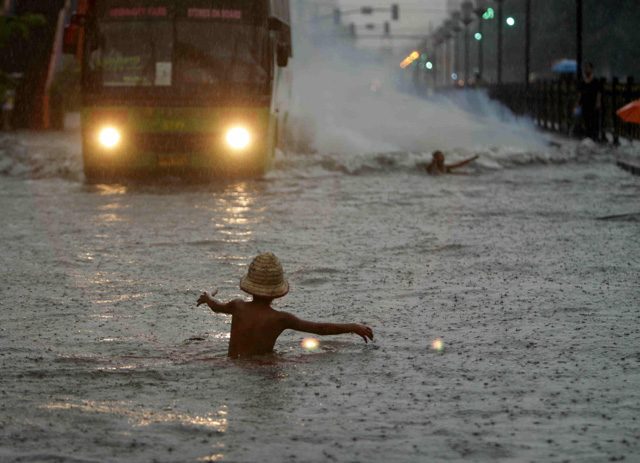
On Friday morning, September 19, different areas of Metro Manila are already experiencing flooding after hours of heavy rainfall due to the combined effect of Mario and the southwest monsoon.
As reports come in, netizens can’t help but compare it to Tropical Storm Ondoy in 2009.
The rain is scary. I remember Ondoy was like this. Non stop rain for how many hours. Please stop now. Please.; Paul Biluan (@PaulBiluan) September 19, 2014
Not another Ondoy, please. Let's pray.
— guinto bob ✌ (@guintobob_CPA) September 19, 2014Will history repeat itself? On September 2009, Typhoon Ondoy hit the country. The water levels in several areas are similar to Ondoy. 🙁
— Gelo Gonzales (@GeloChoi08) September 19, 2014In September 2009, Ondoy brought massive rainfall and caused severe flooding in Luzon, particularly in Metro Manila and neighboring provinces. In just 9 hours, the tropical storm dumped over a month’s volume of rain.
Its effects were devastating, leaving 464 dead and damages worth P11 billion. (READ: BY THE NUMBERS: Ondoy, Habagat 2012, Habagat 2013)
But state weather bureau PAGASA forecaster Aldzar Aurelio explained that the rainfall amount spells the difference.
“Binuhos niya [Ondoy] within 6 hours [ay] 400 millemeters. ‘Yung ulan ng Ondoy, nalampasan yung average ng ulan sa isang buwan (Ondoy dumped 400 millimeters in 6 hours. Ondoy exceeded the average rainfall for one month),” he told Rappler in a phone interview.
Aurelio said that based on records from the PAGASA Science Garden, the accumulated rainfall in the past 24 hours (8 am September 18 to 8 am September 19) is 268 mm – a little over half of Ondoy’s.
National Disaster Risk Reduction and Management Council (NDRRMC) executive director Alexander Pama also said the floodwaters during Ondoy were more extensive.
“Ang diperensiya ng Ondoy, mas malawak ang inabot ng tubig na baha. Gaya ngayon, alam natin na ang lugar ng Cainta at Pasig [sinalanta ng Ondoy], pero ito ngayon sa mga oras na ito, wala pa tayong nakuhang ulat na ganoon katindi ang baha. Pero pinapa-check pa rin natin. Just to be sure,” he added.
(The difference of Ondoy is that the waters reached wider areas. For example, we know Cainta and Pasig were affected by Ondoy, but as of this time we still do not have reports of severe flooding in those areas. But we’re still checking. Just to be sure.)
But he reminded everyone not to be complacent. “Mas mabuti na nakakasiguro tayo. Kahit tumigil [ang] ulan mamayang gabi, posible na ang ulan galing sa bundok saka pa lang bababa sa ilog natin. Huwag basta magbalikan. Tuloy-tuloy inoobserbahan ito.“
(It’s better to be sure. Even if it stops raining tonight, it’s still possible that waters from mountains will come down to our rivers. Don’t just go back after evacuating. Let’s keep observing.)
Follow Rappler’s live blog for more information, photos, and videos from areas affected by Typhoon #MarioPH (Fung-Wong). – with a report from Carmela Fonbuena/Rappler.com
Stay alert and ready with the latest weather and disaster information through Project Agos.
Add a comment
How does this make you feel?
There are no comments yet. Add your comment to start the conversation.