SUMMARY
This is AI generated summarization, which may have errors. For context, always refer to the full article.

MANILA, Philippines – Typhoon Nona (international name Melor) weakened further on Wednesday morning, December 16, as it moved over the West Philippine Sea.
In its latest bulletin issued 11am on Wednesday, state weather bureau PAGASA said Typhoon Nona was last spotted 90 kilometers west of Ternate, Cavite. It is moving west northwest at 7 kilometers per hour (km/h).
Nona now has maximum winds of 120 km/h near the center and gustiness of up to 150 km/h.
Estimated rainfall amount is still moderate to heavy within the 250-kilometer diameter of the typhoon.
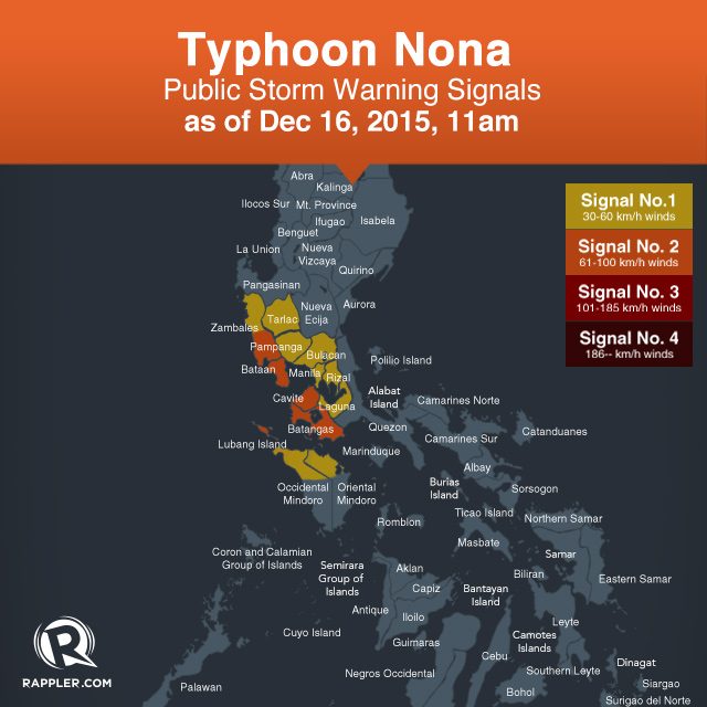
Signal numbers 1 and 2 remain raised in parts of Luzon, but there are no more areas under signal number 3.
Signal #2:
- Bataan
- southern Zambales
- Cavite
- Batangas
- Lubang Island
Signal #1:
- Metro Manila
- rest of Zambales
- Pampanga
- Bulacan
- Tarlac
- Rizal
- Laguna
- northern Occidental Mindoro
- northern Oriental Mindoro
Typhoon Nona is expected to leave the Philippine Area of Responsibility (PAR) on Friday, December 18.

But even before Nona leaves, another weather disturbance is going to enter the Philippine Area of Responsibility (PAR) on Wednesday.
A tropical depression is about 1,180 kilometers east of Mindanao, moving west northwest at 23 km/h. It has maximum winds of 45 km/h.
When the tropical depression enters PAR, it will be named Onyok. – Rappler.com
Add a comment
How does this make you feel?
There are no comments yet. Add your comment to start the conversation.