SUMMARY
This is AI generated summarization, which may have errors. For context, always refer to the full article.

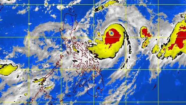
MANILA, Philippines – Typhoon “Lawin” continues to get stronger as it advances towards the Cagayan Valley area, weather bureau PAGASA said on Tuesday, September 25.
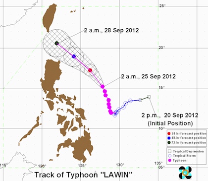
In its 5 am bulletin, PAGASA noted that as of 4 am Lawin (international codename: Jelawat) was 585 km East of Baler, Aurora (15.5°N, 127.7°E), with maximum sustained winds of 195 km/h near the center and gusts of up to 230 km/h.
The typhoon is forecast to move North-Northwest at 11 km/h and on Wednesday morning will be 425 km East of Tuguegarao City by tomorrow morning.
Public storm signal warning #1 is still in effect for Isabela and Cagayan, including Calayan and Babuyan Group of Islands.
Residents living in low lying and mountainous areas in that region are alerted against possible flashfloods and landslides, as the estimated rainfall amount within the 800 km diameter of Lawin is 10–20 mm per hour (heavy – intense).
PAGASA also advised fishing boats and other small seacraft not to venture out into the northern and eastern seaboards of Luzon, Visayas and Mindanao due to the large waves generated by the typhoon.

Weather forecast
According to the weather bureau, Lawin will also enhance the southwest monsoon and continue to bring moderate to heavy rain to southern Luzon, Visayas and Mindanao.
Isabela and Cagayan are expected to have rains and strong winds, while Bicol and Visayas are forecasted to experience cloudy skies with occasional moderate to heavy rains, which may trigger flashfloods and landslides.
Metro Manila, CALABARZON, Mindanao and the rest of Luzon will have occasional light to moderate rain and thunderstorms.
Moderate to strong winds blowing from the Northeast to the Northwest will prevail over central and southern Luzon, and coming from the Southwest over Visayas and Mindanao.
The coastal waters along these areas will be moderate to rough.
Light to moderate winds coming from the Northeast to the Northwest are expected over the rest of Luzon, with slight to moderate seas.
Here is PAGASA’s latest 24-hour public weather forecast for Tuesday, September 25:
– Rappler.com
Add a comment
How does this make you feel?
There are no comments yet. Add your comment to start the conversation.