SUMMARY
This is AI generated summarization, which may have errors. For context, always refer to the full article.
What’s the weather like in your area? Report the situation through Rappler’s Agos or tweet us at @rapplerdotcom.
MANILA, Philippines – Tropical Depression Basyang (Sanba) slightly weakened over the Bohol Sea late Tuesday afternoon, February 13.
Basyang was earlier downgraded from a tropical storm into a tropical depression after it made landfall in Cortes, Surigao del Sur at 9:15 am on Tuesday. At least 4 people have been reported dead in Surigao del Sur.
In a bulletin issued at 5 pm on Tuesday, PAGASA said Basyang is already 25 kilometers southeast of Tagbilaran City, Bohol, moving west at a relatively fast 27 kilometers per hour (km/h).
The tropical depression now has maximum winds of 45 km/h from the previous 55 km/h and gustiness of up to 65 km/h from the previous 80 km/h.
Fewer areas remain under signal number 1:
- Palawan including Calamian and Cuyo
- Aklan
- Capiz
- Antique
- Iloilo
- Guimaras
- Negros Occidental
- Negros Oriental
- Siquijor
- Bohol
- Cebu
- Biliran
- Leyte
- Southern Leyte
- Camiguin
- Misamis Oriental
- Misamis Occidental
- northern part of Zamboanga del Norte
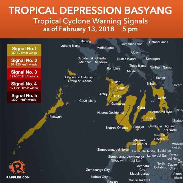
PAGASA warned areas under signal number 1 that moderate to heavy rain will persist within the next 24 hours. Residents should watch out for flash floods and landslides.
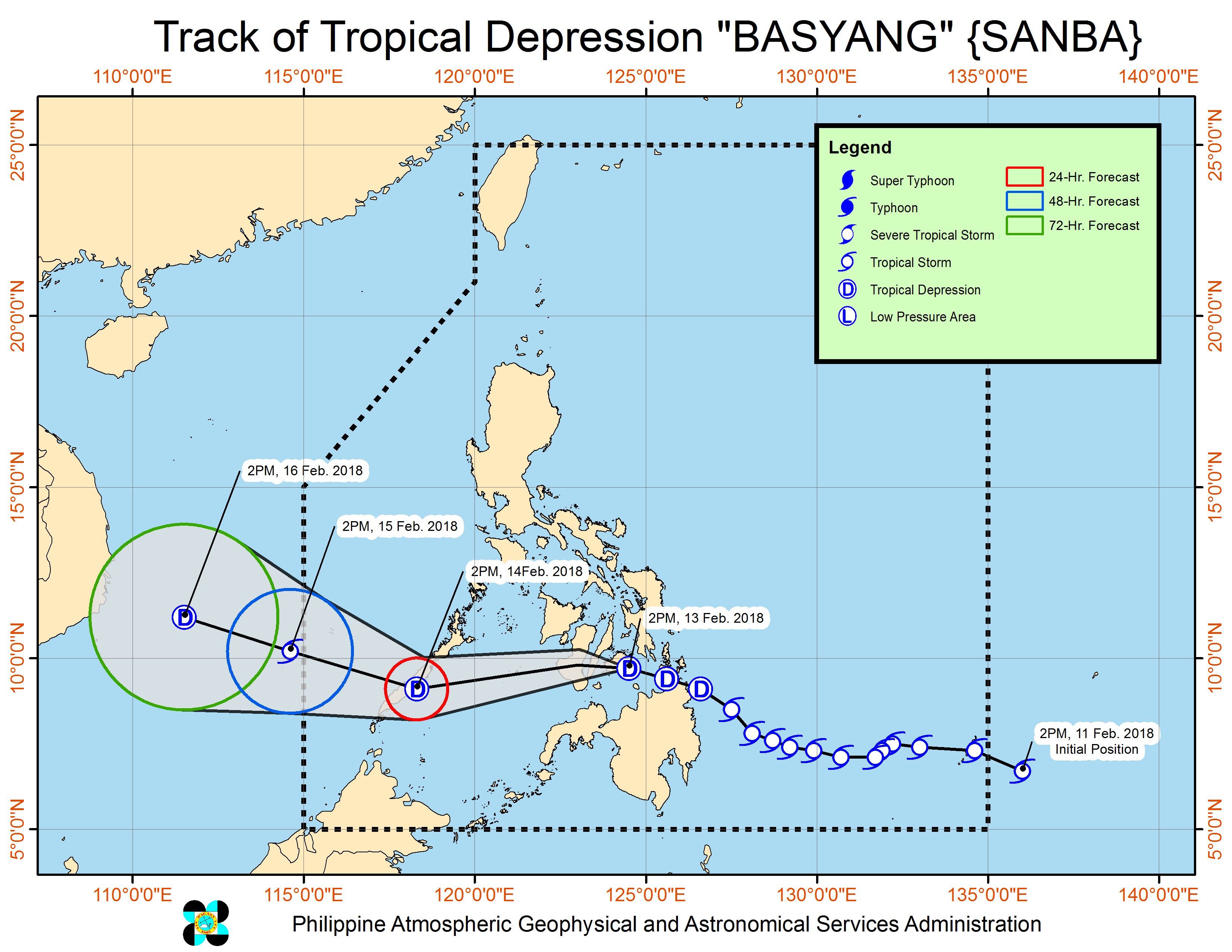
After crossing the Bohol Sea, Basyang is expected to make its 2nd landfall in Bohol, then its 3rd landfall either in Siquijor, the southern part of Cebu, or the southern part of Negros Oriental, before exiting to the Sulu Sea on Tuesday evening.
Once Basyang is over the Sulu Sea, it could reintensify into a tropical storm. Then it would make its final landfall in Palawan by Wednesday afternoon, February 14.
Based on its latest forecast track, Basyang will leave the Philippine Area of Responsibility (PAR) on Thursday morning, February 15.
Sea travel remains risky in areas under signal number 1, the seaboards of Northern Luzon and of the Visayas, the eastern seaboards of Central Luzon and of Mindanao, and the eastern and southern seaboards of Southern Luzon due to Basyang and the surge of the northeast monsoon.
At least 3,982 passengers have been stranded in various ports as of noon on Tuesday, according to the Philippine Coast Guard (PCG).
Meanwhile, the northeast monsoon is affecting the rest of Luzon, but PAGASA said there will be “no significant impact.” (READ: FAST FACTS: Tropical cyclones, rainfall advisories)
– Rappler.com
Add a comment
How does this make you feel?
There are no comments yet. Add your comment to start the conversation.