SUMMARY
This is AI generated summarization, which may have errors. For context, always refer to the full article.
What’s the weather like in your area? Report the situation through Rappler’s Agos or tweet us at @rapplerdotcom.
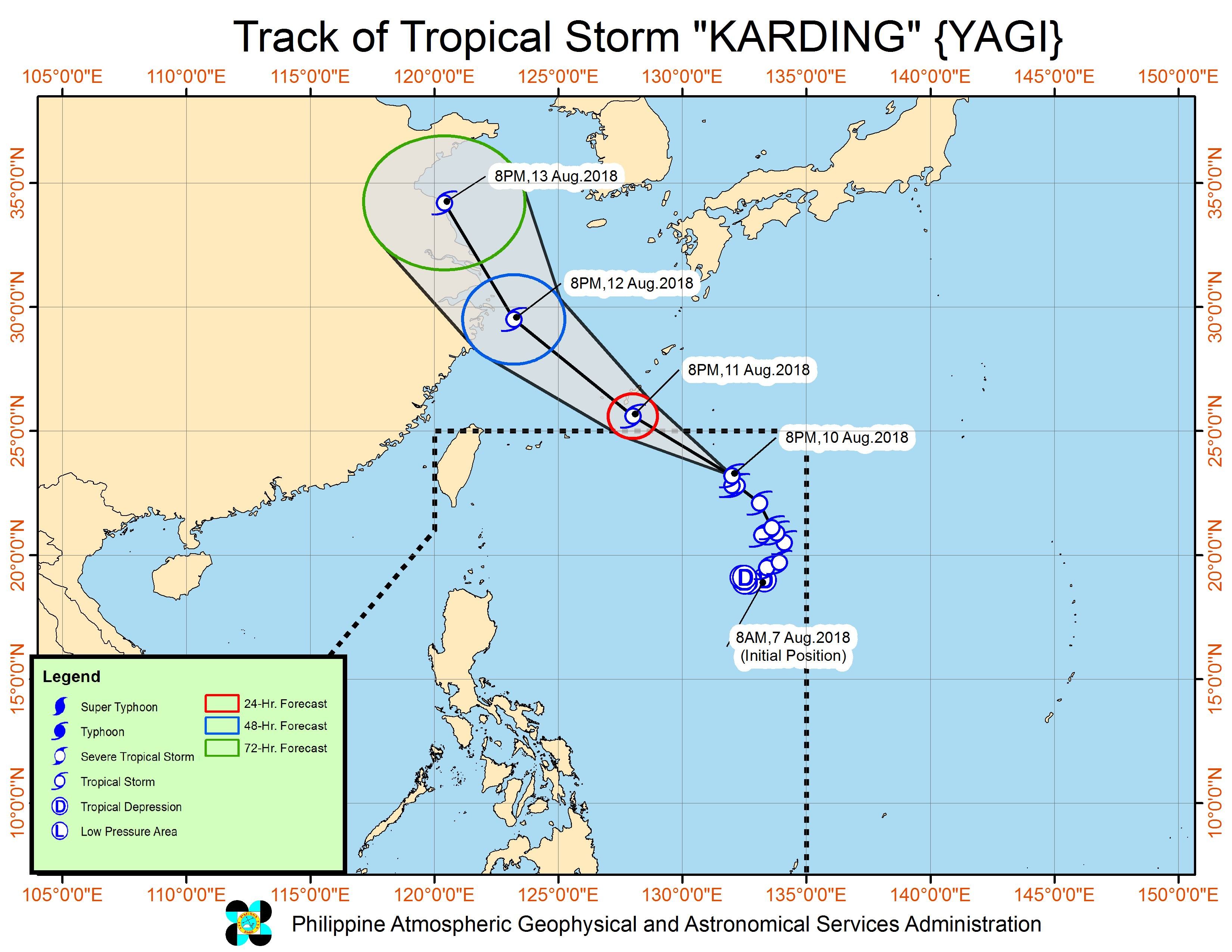
MANILA, Philippines – Tropical Storm Karding (Yagi) and a tropical depression outside the Philippine Area of Responsibility (PAR) will continue to enhance the southwest monsoon or hanging habagat on Saturday, August 11.
In a bulletin issued 11 pm on Friday, August 10, the Philippine Atmospheric, Geophysical, and Astronomical Services Administration (PAGASA) said Karding is located 1,075 kilometers east northeast of Basco, Batanes, slowly moving north.
The tropical storm still has maximum winds of 75 kilometers per hour (km/h) and gustiness of up to 90 km/h.
There are no areas under tropical cyclone warning signals, and Karding is not expected to make landfall in the Philippines.
But PAGASA warned that the tropical storm and the tropical depression outside PAR will both continue enhancing the southwest monsoon.
The tropical depression is located 1,065 kilometers west of extreme Northern Luzon, also slowly moving north. It continues to have maximum winds of 55 km/h and gustiness of up to 75 km/h.
Due to the enhanced southwest monsoon, moderate to heavy rain will persist in Batanes, the Babuyan Group of Islands, the Ilocos Region, the Cordillera Administrative Region, and the western part of Central Luzon.
Light to heavy rain will also continue in Metro Manila, Oriental Mindoro, Occidental Mindoro, Calabarzon, the rest of Cagayan Valley, and the rest of Central Luzon.
PAGASA advised residents of these areas to be on alert for flash floods and landslides. (READ: FAST FACTS: Tropical cyclones, rainfall advisories)
The state weather bureau also warned that sea travel remains risky in the western seaboard of Luzon.
A gale warning was issued for Batanes, the Calayan Group of Islands, the Babuyan Group of Islands, Ilocos Norte, Ilocos Sur, La Union, Pangasinan, Zambales, Bataan, Cavite, the western coast of Batangas, Occidental Mindoro, and northern Palawan. This means seas off these areas are rough to very rough, with wave heights reaching 2.6 meters to 4.5 meters.
Fishermen and others with small vessels were advised not to set sail in areas covered by the gale warning. Larger vessels should watch out for big waves.
Based on its latest forecast track, Karding will leave PAR on Saturday evening.
Karding is the Philippines’ 11th tropical cyclone for 2018. The country usually gets an average of 20 tropical cyclones per year. (READ: LIST: PAGASA’s names for tropical cyclones in 2018)
PAGASA declared the start of the rainy season last June 8. – Rappler.com
Add a comment
How does this make you feel?
There are no comments yet. Add your comment to start the conversation.