SUMMARY
This is AI generated summarization, which may have errors. For context, always refer to the full article.
What’s the weather like in your area? Report the situation through Rappler’s Agos or tweet us at @rapplerdotcom.
MANILA, Philippines – The southwest monsoon or hanging habagat will bring more rain to parts of Luzon on Tuesday, August 21, a holiday nationwide for Ninoy Aquino Day and Eid’l Adha.
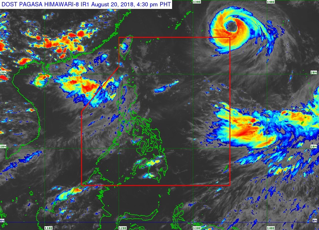
In a bulletin issued 4 pm on Monday, August 20, the Philippine Atmospheric, Geophysical, and Astronomical Services Administration (PAGASA) said the southwest monsoon is being enhanced by Typhoon Soulik, which is outside the Philippine Area of Responsibility (PAR).
Soulik is 1,510 kilometers east northeast of extreme Northern Luzon, moving west northwest at 15 kilometers per hour (km/h), and unlikely to enter PAR. It has maximum winds of 150 km/h and gustiness of up to 185 km/h.
Monsoon rain is expected in the Ilocos Region, the Cordillera Administrative Region, Batanes, the Babuyan Group of Islands, Zambales, and Bataan on Tuesday.
These places were already hit by heavy rain on Monday, prompting the suspension of classes in some areas.
PAGASA warned that the monsoon rain would again be moderate to heavy on Tuesday. Residents should stay on alert for flash floods and landslides.
The southwest monsoon will also bring scattered rains and thunderstorms to Metro Manila, the rest of Central Luzon, Calabarzon, Oriental Mindoro, Occidental Mindoro, and northern Palawan on Tuesday. Flash floods and landslides are possible, too. (READ: FAST FACTS: Tropical cyclones, rainfall advisories)
The rest of the country, not affected by the southwest monsoon, will have localized thunderstorms. There could be floods and landslides as well if the thunderstorms bring heavy rain.
Aside from Soulik, PAGASA is also monitoring Severe Tropical Storm Cimaron outside PAR.
Cimaron is located 2,765 kilometers east of Northern Luzon, moving west northwest at 20 km/h. It has maximum winds of 105 km/h and gustiness of up to 130 km/h.
Like Soulik, Cimaron is unlikely to enter PAR. The severe tropical storm has no direct effect on the country.
So far, the Philippines has had 11 tropical cyclones in 2018. The country usually gets an average of 20 tropical cyclones per year. (READ: LIST: PAGASA’s names for tropical cyclones in 2018)
PAGASA declared the start of the rainy season last June 8. – Rappler.com
Add a comment
How does this make you feel?
There are no comments yet. Add your comment to start the conversation.