SUMMARY
This is AI generated summarization, which may have errors. For context, always refer to the full article.
What’s the weather like in your area? Report the situation through Rappler’s Agos or tweet us at @rapplerdotcom.
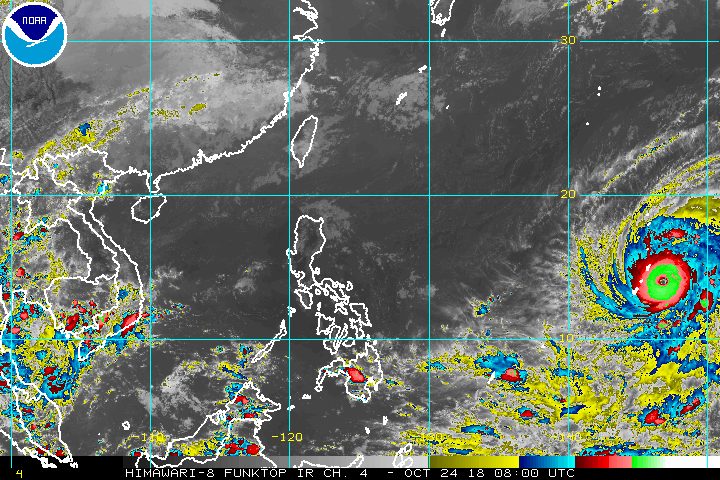
MANILA, Philippines – Typhoon Yutu, which is located outside the Philippine Area of Responsibility (PAR), strengthened on Wednesday afternoon, October 24.
In a bulletin issued 4 pm on Wednesday, the Philippine Atmospheric, Geophysical, and Astronomical Services Administration (PAGASA) said Yutu now has maximum winds of 185 kilometers per hour (km/h) and gustiness of up to 225 km/h.
Just a day ago, its maximum winds were at 130 km/h and its gustiness was at 160 km/h. Since it remains over water, it could intensify further.
The typhoon is now located 2,450 kilometers east of Luzon, moving west northwest at a slightly faster 20 km/h from the previous 15 km/h.
In a Facebook Live video late Wednesday afternoon, PAGASA Weather Specialist Meno Mendoza said Yutu could enter PAR on Saturday, October 27. If it does, it would be given the local name Rosita. (READ: LIST: PAGASA’s names for tropical cyclones in 2018)
At the moment, the typhoon is still too far to determine a highly probable or definite track. More detailed forecasts are expected in the coming days.
So far, the Philippines has had 17 tropical cyclones in 2018. The country usually gets an average of 20 tropical cyclones per year.
Meanwhile, the intertropical convergence zone (ITCZ) will continue to affect Mindanao on Thursday, October 25.
The ITCZ is a belt near the equator where the trade winds of the Northern Hemisphere and Southern Hemisphere meet, usually causing low pressure areas or thunderstorms. (READ: FAST FACTS: Tropical cyclones, rainfall advisories)
Scattered rainshowers and thunderstorms are expected in the Davao Region and Soccsksargen due to the ITCZ. Residents of these areas should watch out for possible flash floods and landslides.
The rest of the country will only have localized thunderstorms, mostly in the afternoon or evening. Flash floods and landslides are also possible if the thunderstorms bring heavy rain.
PAGASA declared the start of the rainy season last June 8. – Rappler.com
Add a comment
How does this make you feel?
There are no comments yet. Add your comment to start the conversation.