SUMMARY
This is AI generated summarization, which may have errors. For context, always refer to the full article.
What’s the weather like in your area? Report the situation through Rappler’s Agos or tweet us at @rapplerdotcom.
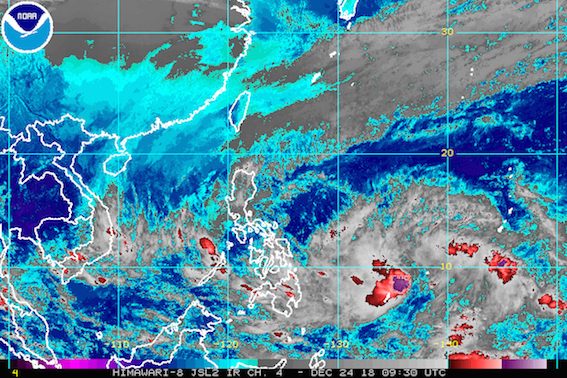
MANILA, Philippines – The first low pressure area (LPA) that’s been affecting the country is already on its way out of the Philippine Area of Responsibility (PAR), but a second LPA is expected to enter soon.
In a briefing past 5 pm on Christmas Eve, Monday, December 24, the Philippine Atmospheric, Geophysical, and Astronomical Services Administration (PAGASA) said the first LPA is now 430 kilometers west northwest of Puerto Princesa City, Palawan.
Though it is set to exit, the LPA’s trough or extension will still trigger light to heavy rain in Palawan. Flash floods and landslides remain possible.
The second LPA, meanwhile, is now 1,245 kilometers east of Mindanao. It is expected to enter PAR within the next 24 to 36 hours.
But even before its entry, the second LPA’s trough will already bring light to heavy rain to Mindanao, Central Visayas, and Eastern Visayas.
Residents of those areas should watch out for possible flash floods and landslides. (READ: FAST FACTS: Tropical cyclones, rainfall advisories)
“Unahin ang kaligtasan bago ang kasiyahan (Prioritize safety over Christmas celebrations),” said PAGASA Weather Specialist Ariel Rojas in the briefing.
The second LPA might also become a tropical depression within the next 24 to 48 hours. If it does, it would be given the local name Usman, the Philippines’ 21st tropical cyclone for 2018. The country’s average number of tropical cyclones per year is 20. (READ: LIST: PAGASA’s names for tropical cyclones in 2018)
PAGASA earlier said that one to two tropical cyclones could enter or develop within PAR in December.
At the moment, the potential tropical cyclone’s track is not yet definite, but it could affect Caraga, Eastern Visayas, and Bicol. Its possible landfall may be in the Samar-Bicol area on Friday, December 28.
The public should continue monitoring updates in case the forecast changes.
Cold front
Aside from the two LPAs, there’s also the tail-end of a cold front.
A cold front forms when an advancing cold air mass displaces warmer air in its path, causing the displaced warm air to rise, which then leads to the formation of clouds and precipitation.
Light to heavy rain will hit Metro Manila, Central Luzon, Laguna, Rizal, and Quezon due to the tail-end of a cold front.
PAGASA warned that flash floods and landslides are also possible in those areas.
Northeast monsoon
Meanwhile, the northeast monsoon or hanging amihan will cause light to moderate rain over Cagayan Valley and the Cordillera Administrative Region, as well as isolated rainshowers in the Ilocos Region. PAGASA said there will be “no significant impact.”
Due to the northeast monsoon, however, a gale warning was issued at 5 pm on Monday for Batanes, Calayan, Babuyan, Ilocos Norte, and the northern coast of Cagayan.
Seas off those areas are rough to very rough, with wave heights reaching 2.8 meters to 4.5 meters.
PAGASA advised fishermen and others with small vessels not to set sail in areas covered by the gale warning. Larger vessels should watch out for big waves.
PAGASA declared the start of the rainy season last June 8. – Rappler.com
Add a comment
How does this make you feel?
There are no comments yet. Add your comment to start the conversation.