SUMMARY
This is AI generated summarization, which may have errors. For context, always refer to the full article.
What’s the weather like in your area? Report the situation through Rappler’s Agos or tweet us at @rapplerdotcom.
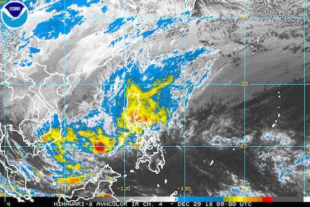
MANILA, Philippines – The low pressure area (LPA) which used to be Tropical Depression Usman, the tail-end of a cold front, and the northeast monsoon or hanging amihan are all bringing rain from Saturday, December 29, to Sunday, December 30.
In a bulletin issued 4 pm on Saturday, the Philippine Atmospheric, Geophysical, and Astronomical Services Administration (PAGASA) said the LPA is already 60 kilometers east of Romblon, Romblon.
As for the cold front, it forms when an advancing cold air mass displaces warmer air in its path, causing the displaced warm air to rise, which then leads to the formation of clouds and precipitation. (READ: FAST FACTS: Tropical cyclones, rainfall advisories)
The LPA and the tail-end of a cold front combined are triggering moderate to heavy rain in Bicol, Calabarzon, Oriental Mindoro, Occidental Mindoro, Marinduque, Romblon, and the northern part of Palawan.
The two weather systems are also bringing scattered rainshowers and thunderstorms to Metro Manila, the Visayas, and the southern part of Palawan.
The northeast monsoon, meanwhile, is causing light to heavy rain in Central Luzon, the Ilocos Region, the Cordillera Administrative Region, and Cagayan Valley.
PAGASA advised all areas affected by the LPA, the tail-end of a cold front, and the northeast monsoon to stay on alert for flash floods and landslides. Usman had already triggered floods and landslides, and also caused damage. (READ: Tribal leader seeks help for displaced Mamanwa families in Samar)
Mindanao, in contrast, will have generally good weather, with only isolated rainshowers or thunderstorms.
Also due to the surge of the northeast monsoon, a gale warning was issued at 5 pm on Saturday for the following areas:
- Camarines Norte, Camarines Sur, Catanduanes, the eastern coast of Albay, the eastern coast of Sorsogon, the eastern coast of Quezon including Polillo Island – very rough to high seas, wave heights of 4.5 to 7 meters
- Batanes, Calayan, Babuyan, Cagayan, Isabela, Ilocos Norte, Ilocos Sur, La Union, Pangasinan, Zambales, Bataan, Aurora – rough to high seas, wave heights of 2.8 to 7 meters
- the western, eastern, and southern coasts of the Mindoro provinces, the southern coast of Batangas, the southern coast of Quezon, Marinduque, the northern part of Palawan – rough to very rough seas, wave heights of 2.8 to 5 meters
- Northern Samar, Eastern Samar – rough to very rough seas, wave heights of 2.8 to 4.5 meters
PAGASA advised fishermen and others with small vessels not to set sail in areas covered by the gale warning. Larger vessels should watch out for big waves.
The weather is expected to improve on Monday, December 31, New Year’s Eve.
In total, the Philippines had 21 tropical cyclones in 2018. The country’s average number of tropical cyclones per year is only 20. (READ: LIST: PAGASA’s names for tropical cyclones in 2018)
PAGASA declared the start of the rainy season last June 8. – Rappler.com
Add a comment
How does this make you feel?
There are no comments yet. Add your comment to start the conversation.