SUMMARY
This is AI generated summarization, which may have errors. For context, always refer to the full article.
What’s the weather like in your area? Report the situation through Rappler’s Agos or tweet us at @rapplerdotcom.
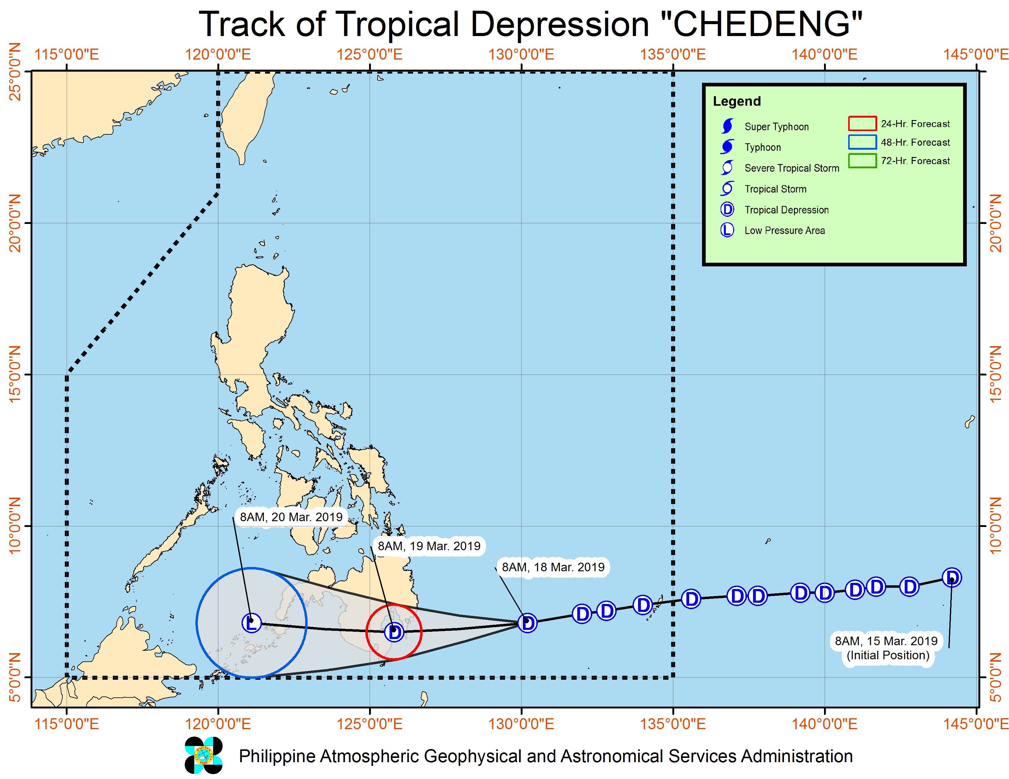
MANILA, Philippines – Tropical Depression Chedeng maintained its strength late Monday morning, March 18, as it continued heading for the Davao Region.
In a briefing past 11 am on Monday, the Philippine Atmospheric, Geophysical, and Astronomical Services Administration (PAGASA) said Chedeng is now 445 kilometers east of Davao City. It is moving west at a slightly faster 20 kilometers per hour (km/h) from the previous 15 km/h.
The tropical depression continues to have maximum winds of 45 km/h and gustiness of up to 60 km/h.
There are now 10 areas under Signal No. 1:
- Davao Oriental
- Compostela Valley
- Davao del Sur
- Davao City
- General Santos City
- Davao Occidental
- southern part of Davao del Norte including Samal Island
- eastern part of North Cotabato
- eastern part of South Cotabato
- eastern part of Sarangani
PAGASA warned that moderate to heavy rain will persist in the regions of Caraga and Davao on Monday, especially in Surigao del Sur, the eastern part of Agusan del Sur, Davao Oriental, and Compostela Valley.
On Tuesday, March 19, moderate to heavy rain may also hit the Davao Region, Soccsksargen, Bangsamoro Autonomous Region in Muslim Mindanao, and Zamboanga Peninsula.
Chedeng might make landfall in the eastern coast of Davao Oriental on Tuesday morning, and then weaken into a low pressure area while crossing Mindanao.
PAGASA reiterated that residents of Mindanao must be on alert for possible flash floods and landslides.
The state weather bureau did note, however, that Mindanao has been experiencing below normal rainfall for the past couple of months. This means that some rain may be welcome, especially for farmers dealing with the dry spell.
“Huwag ho tayo mag-relax…. Kahit welcome, kailangan mag-ingat dahil bagyo ito (Let’s not relax…. Even if it may be welcome, we have to be careful because this is still a tropical cyclone),” PAGASA Deputy Administrator for Operations and Services Landrico Dalida Jr said during the briefing.
PAGASA also warned those with small vessels not to set sail in the eastern seaboards of the Visayas and Mindanao, as well as in areas under Signal No. 1. (READ: FAST FACTS: Tropical cyclones, rainfall advisories)
Before Chedeng, the Philippines had Tropical Depression Amang in January and Tropical Depression Betty in February. (READ: LIST: PAGASA’s names for tropical cyclones in 2019)
The country gets an average of 20 tropical cyclones per year, but PAGASA expects only 14 to 18 in 2019. The number is likely to be below average as a “full-blown” El Niño looms.
Below is the estimated number of tropical cyclones from March to August:
- March – 0 or 1
- April – 0 or 1
- May – 1 or 2
- June – 1 or 2
- July – 2 or 3
- August – 2 or 3
Meanwhile, other parts of the country – not affected by Chedeng – will only have isolated rainshowers on Monday. – Rappler.com
Add a comment
How does this make you feel?
There are no comments yet. Add your comment to start the conversation.