SUMMARY
This is AI generated summarization, which may have errors. For context, always refer to the full article.
What’s the weather like in your area? Tweet us at @rapplerdotcom.
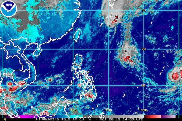
MANILA, Philippines – Perla (Neoguri) left the Philippine Area of Responsibility (PAR) at 5:15 pm on Sunday, October 20, then weakened from a typhoon into a severe tropical storm.
In a briefing past 11 pm on Sunday, the Philippine Atmospheric, Geophysical, and Astronomical Services Administration (PAGASA) said Perla is already 1,035 kilometers northeast of Basco, Batanes.
It is still moving north northeast at 20 kilometers per hour (km/h).
Perla now has maximum winds of 110 km/h from the previous 130 km/h in the afternoon and gustiness of up to 135 km/h from the previous 160 km/h.
It did not make landfall in the country and tropical cyclone wind signals were not raised. (READ: FAST FACTS: Tropical cyclones, rainfall advisories)
Perla was the Philippines’ 16th tropical cyclone for 2019, and the 1st for October. (READ: LIST: PAGASA’s names for tropical cyclones in 2019)

While Perla has left PAR, PAGASA continues to monitor the severe tropical storm with the international name Bualoi.
Bualoi is now 2,690 kilometers east of the Visayas, moving northwest at the same pace of 20 km/h.
It continues to strengthen and now has maximum winds of 110 km/h from the previous 95 km/h and gustiness of up to 135 km/h from the previous 115 km/h.
PAGASA Weather Specialist Loriedin de la Cruz said Bualoi only has a slim chance of entering PAR. The public, however, should keep track of updates.
The country gets an average of 20 tropical cyclones annually, but since 2019 is an El Niño year, only 14 to 18 tropical cyclones are expected.
Below is the estimated number of tropical cyclones from October to December:
- October – 2 or 3
- November – 1 or 2
- December – 0 or 1
Meanwhile, the northeasterly surface windflow is again expected to bring isolated light rain to these areas on Monday, October 21:
- Batanes
- Ilocos Norte
- Apayao
- Cagayan
There may be occasional gusty conditions in extreme Northern Luzon until Monday as well.
Also due to the windflow, travel remains risky in the seaboards of Northern Luzon, especially for small vessels.
The rest of the country will still enjoy good weather on Monday. There may only be isolated rainshowers or localized thunderstorms, mostly in the afternoon or evening.
PAGASA declared the start of the rainy season last June 14. – Rappler.com
Add a comment
How does this make you feel?
There are no comments yet. Add your comment to start the conversation.