SUMMARY
This is AI generated summarization, which may have errors. For context, always refer to the full article.
What’s the weather like in your area? Tweet us at @rapplerdotcom.
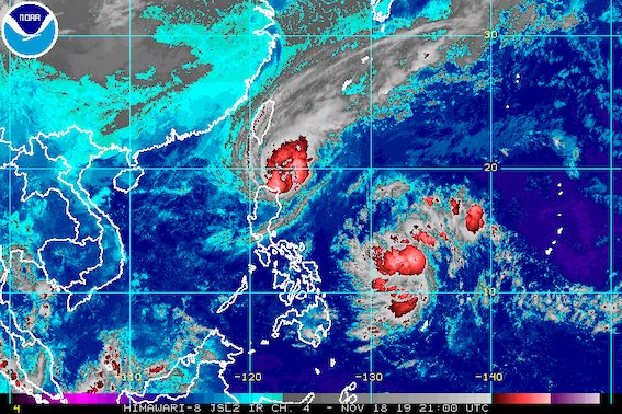
MANILA, Philippines – Typhoon Ramon (Kalmaegi) continued to move toward the Babuyan Group of Islands before dawn on Tuesday, November 19, while the low pressure area (LPA) that forecasters have also been monitoring entered the Philippine Area of Responsibility (PAR).
In a bulletin issued 5 am on Tuesday, the Philippine Atmospheric, Geophysical, and Astronomical Services Administration (PAGASA) said Ramon is now 120 kilometers east of Calayan, Cagayan.
The typhoon is still moving west northwest at a slow 10 kilometers per hour (km/h).
It continues to have maximum winds of 120 km/h and gustiness of up to 150 km/h.
Based on its latest forecast track, Ramon is expected to make landfall in the Babuyan Group of Islands between Tuesday morning and afternoon, and again in the northern coast of Cagayan between Tuesday afternoon and evening.
It is forecast to gradually weaken after hitting land, “due to the land interaction and the northeast monsoon,” said PAGASA.
Here is the latest list of areas under tropical cyclone wind signals:
Signal No. 3 (winds of 121 km/h to 170 km/h)
- northern part of Cagayan (Santa Praxedes, Claveria, Sanchez Mira, Pamplona, Abulug, Ballesteros, Aparri, Calayan, Camalaniugan, Buguey, Santa Teresita, Gonzaga, Santa Ana)
Signal No. 2 (winds of 61 km/h to 120 km/h)
- rest of Cagayan
- Batanes
- Apayao
- Kalinga
- Abra
- lIocos Norte
- Ilocos Sur
Signal No. 1 (winds of 30 km/h to 60 km/h)
- northern part of Isabela (Sta Maria, San Pablo, Maconacon, Cabagan, Sto Tomas, Quezon, Delfin Albano, Tumauini, Divilacan, Quirino, Roxas, Mallig, San Manuel, Burgos, Gamu, Ilagan City)
- Mountain Province
- Benguet
- Ifugao
- La Union
- Pangasinan
The rain from Ramon will be heaviest on Tuesday. Flash floods and landslides remain possible. (READ: FAST FACTS: Tropical cyclones, rainfall advisories)
Tuesday, November 19
- Moderate rain with frequent heavy rain
- Batanes
- northern part of Cagayan, including Babuyan Group of Islands
- Apayao
- northern part of Ilocos Norte
- Light to moderate rain with intermittent heavy rain
- northern part of Isabela
- Kalinga
- Abra
- rest of Cagayan
- Ilocos Sur
Wednesday, November 20
- Light to moderate rain with occasionally heavy rain
- Batanes
- northern and eastern parts of Cagayan, including Babuyan Group of Islands
- eastern part of Isabela
- eastern part of Apayao
- eastern part of Kalinga
- Light to moderate rain with intermittent heavy rain
- northern part of Aurora
- rest of Cagayan
- rest of Isabela
Classes were suspended in some areas for Tuesday. (READ: #WalangPasok: Class suspensions, Tuesday, November 19, 2019)
Travel also remains risky, especially for small vessels, in the seaboards of areas under tropical cyclone wind signals, the seaboard of the southern part of Isabela, as well as the western seaboard of Zambales and Bataan.
Ramon could leave PAR early Thursday, November 21. By then, it would have likely weakened into a tropical depression.
Ramon is the Philippines’ 18th tropical cyclone for 2019, and the 2nd for November.
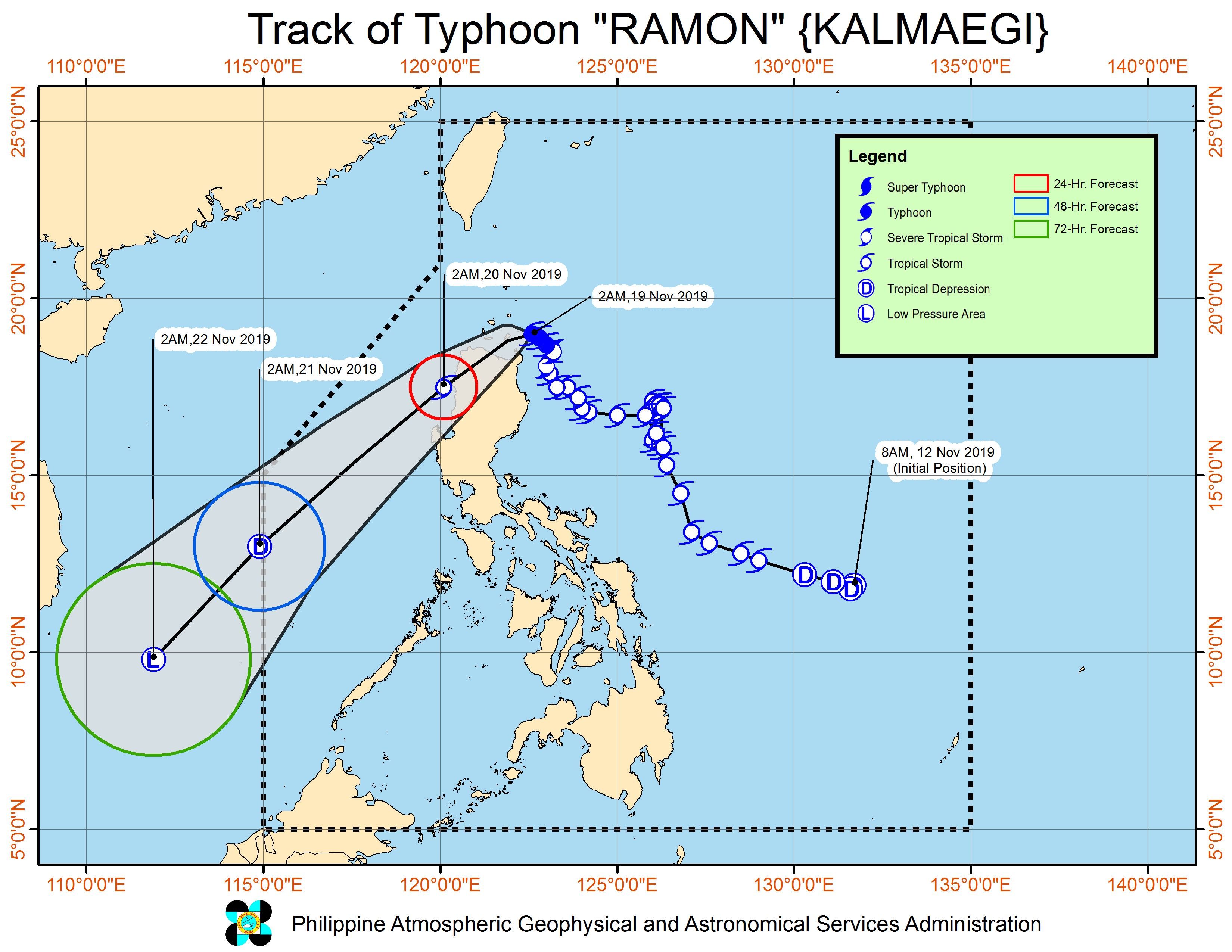
Meanwhile, the LPA entered PAR at 2 am on Tuesday, and is now 930 kilometers east of Guiuan, Eastern Samar.
At the moment, it is not affecting any part of the country. But it is likely to develop into a tropical depression within 24 hours.
If it becomes a tropical depression, it would be given the local name Sarah – potentially the Philippines’ 19th tropical cyclone for 2019, and the 3rd for November. (READ: LIST: PAGASA’s names for tropical cyclones in 2019)
The country gets an average of 20 tropical cyclones annually, but since 2019 is an El Niño year, only 14 to 18 tropical cyclones had been projected.
Below is the estimated number of tropical cyclones for the last two months of 2019:
- November – 1 or 2 (if Sarah forms, the estimate would be exceeded)
- December – 0 or 1
PAGASA declared the start of the rainy season last June 14. – Rappler.com
Add a comment
How does this make you feel?
There are no comments yet. Add your comment to start the conversation.