SUMMARY
This is AI generated summarization, which may have errors. For context, always refer to the full article.
What’s the weather like in your area? Tweet us at @rapplerdotcom.
MANILA, Philippines – Signal No. 2 was raised for the first time due to Typhoon Tisoy (Kammuri), which accelerated on Sunday morning, December 1.
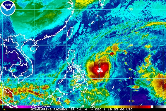
In a press briefing past 11 am on Sunday, the Philippine Atmospheric, Geophysical, and Astronomical Services Administration (PAGASA) said Tisoy is already 705 kilometers east of Virac, Catanduanes.
It is now moving west at 25 kilometers per hour (km/h) from the previous 15 km/h.
The typhoon slightly weakened, now with maximum winds of 140 km/h from the previous 150 km/h and gustiness of up to 170 km/h from the previous 185 km/h.
“Pinapasukan na siya ng medyo malamig na hangin dahil do’n sa northeast [monsoon] (It’s interacting with the cold air from the northeast monsoon),” said Robert Sawi, assistant weather services chief of PAGASA’s Weather Division, explaining why Tisoy slightly weakened.
But this does not mean that the public should be complacent, since Tisoy is still a typhoon.
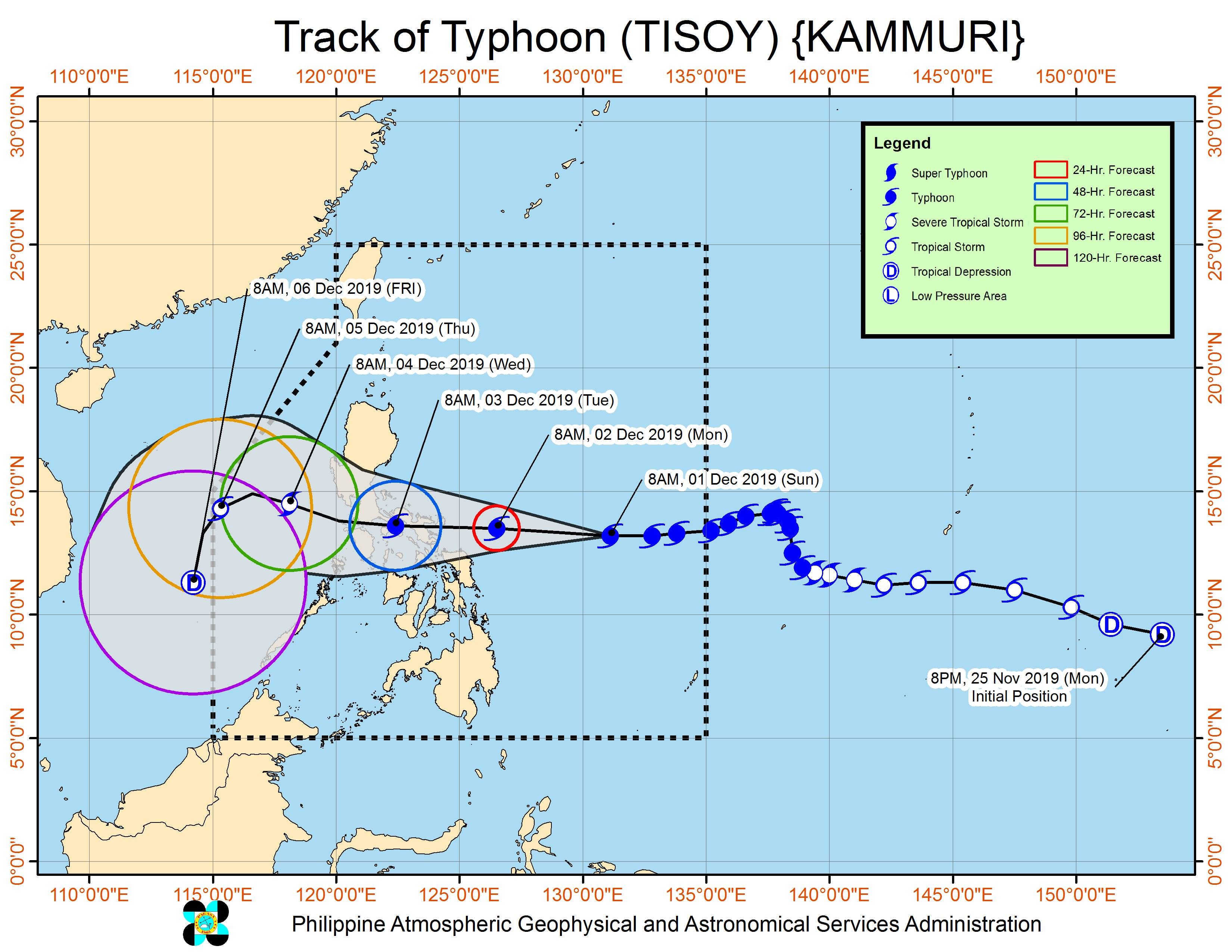
Tisoy is expected to make landfall in Bicol between Monday evening, December 2, and early Tuesday morning, December 3.
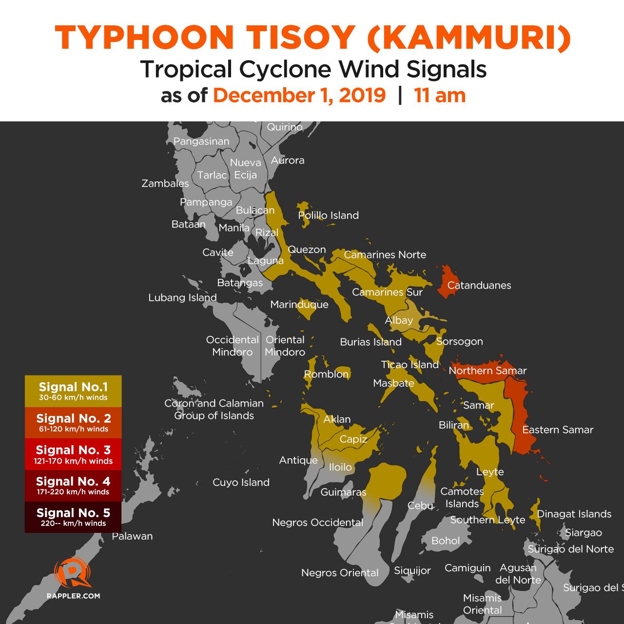
Below is the latest list of areas under tropical cyclone wind signals. More places in Luzon and the Visayas have been added, and even one in Mindanao.
Signal No. 2 (winds of 61 km/h to 120 km/h)
- Catanduanes
- Northern Samar
- Eastern Samar
Signal No. 1 (winds of 30 km/h to 60 km/h)
- Quezon including Polillo Island
- Camarines Norte
- Camarines Sur
- Albay
- Sorsogon
- Masbate including Burias Island and Ticao Island
- Marinduque
- Romblon
- Aklan
- Capiz
- northern part of Iloilo (Ajuy, Anilao, Balasan, Banate, Barotac Viejo, Batad, Bingawan, Calinog, Carles, Concepcion, Dingle, Dueñas, Estancia, Lambunao, Lemery, Passi City, San Dionisio, San Enrique, San Rafael, Sara)
- northern part of Antique (Culasi, Libertad, Pandan, Sebaste, Tibiao)
- northern part of Negros Occidental (Cadiz City, Calatrava, Enrique B Magalona, Escalante City, Manapla, Sagay City, Silay City, Toboso, Victorias City)
- northern part of Cebu (Asturias, Bantayan, Bogo City, Borbon, Carmen, Catmon, Daanbantayan, Danao City, Madridejos, Medellin, Pilar, Poro, San Francisco, San Remigio, Santa Fe, Sogod, Tabogon, Tabuelan, Tuburan, Tudela)
- Samar
- Biliran
- Camotes Islands
- Leyte
- Southern Leyte
- Dinagat Islands
Tisoy is also forecast to bring heavy rain starting Monday. Here is PAGASA’s latest rainfall outlook:
Monday, December 2
- Occasional to frequent heavy rain
- Bicol
- Eastern Samar
- Northern Samar
- Samar
- Biliran
- Moderate to occasional heavy rain
- Romblon
- Marinduque
- Quezon
Tuesday, December 3
- Frequent to continuous heavy rain
- Metro Manila
- Bicol
- Calabarzon
- Occidental Mindoro
- Oriental Mindoro
- Marinduque
- Romblon
- Zambales
- Bataan
- Pampanga
- Bulacan
- Moderate to occasional heavy rain
- rest of Luzon
- Aklan
- Capiz
- northern part of Antique
Areas in Tisoy’s path must brace for possible flash floods and landslides. These include areas where events of the 2019 Southeast Asian Games are set, particularly Metro Manila, Zambales, and Pampanga.
Classes have been suspended in some areas for Monday. (READ: #WalangPasok: Class suspensions, Monday, December 2, 2019)
Travel is also risky, especially for small vessels, in the seaboards of areas under Signal Nos. 1 and 2, the northern and western seaboards of Northern Luzon, and the eastern seaboards of the Philippines.
Sea travel will be disrupted, especially if tropical cyclone wind signals have been raised in particular areas. (READ: FAST FACTS: Tropical cyclones, rainfall advisories)
Based on its latest forecast track, Tisoy is expected to leave the Philippine Area of Responsibility on Thursday morning, December 5.
Tisoy is the Philippines’ 20th tropical cyclone for 2019. (READ: LIST: PAGASA’s names for tropical cyclones in 2019)
The country gets an average of 20 tropical cyclones annually. In the earlier part of the year, only 14 to 18 tropical cyclones had been projected since 2019 is an El Niño year.
For the month of December, PAGASA had been expecting 0 to 1 tropical cyclone.
PAGASA declared the start of the rainy season last June 14. – Rappler.com
Add a comment
How does this make you feel?
There are no comments yet. Add your comment to start the conversation.