SUMMARY
This is AI generated summarization, which may have errors. For context, always refer to the full article.
What’s the weather like in your area? Tweet us at @rapplerdotcom.
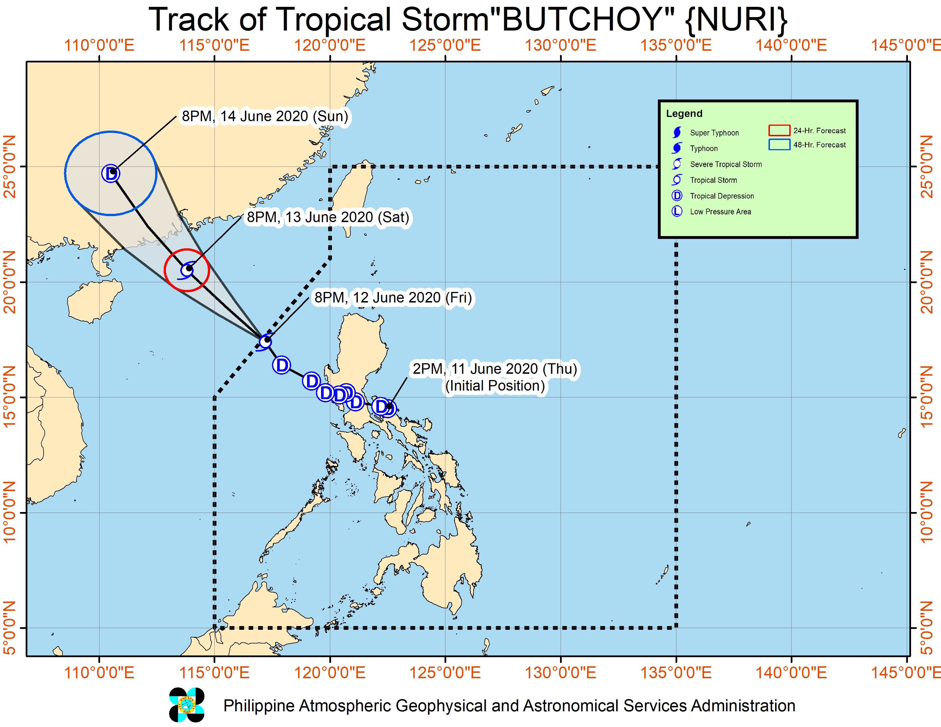
MANILA, Philippines – Butchoy strengthened from a tropical depression into a tropical storm and left the Philippine Area of Responsibility (PAR) on Friday evening, June 12.
In a bulletin issued past 11 pm on Friday, the Philippine Atmospheric, Geophysical, and Astronomical Services Administration (PAGASA) said Butchoy was given the international name Nuri. It is a name contributed by Malaysia which means blue-crowned parroquet, a type of bird.
The tropical storm is already 415 kilometers west northwest of Dagupan City, Pangasinan, or 380 kilometers west of Sinait, Ilocos Sur. It is moving northwest at 20 kilometers per hour (km/h).
As Butchoy left PAR, its maximum winds increased to 65 km/h from the previous 55 km/h, while its gustiness is now up to 80 km/h from the previous 70 km/h. (READ: FAST FACTS: Tropical cyclones, rainfall advisories)
Butchoy had made landfall as a tropical depression twice in Quezon province on Thursday, June 11 – Polillo at 5:30 pm and Infanta at 6 pm – before swiftly crossing Central Luzon late Thursday and early Friday.
The highest tropical cyclone wind signal raised was Signal No. 1. By 11 am on Friday, there were no longer any areas under Signal No. 1. (READ: Why is it now called tropical cyclone ‘wind’ – and not ‘warning’ – signals?)
No casualties have been reported, so far.
Though Butchoy has left PAR, PAGASA noted that the effects of the southwest monsoon or hanging habagat may still be felt.
There could be occasional gusts in most of Northern Luzon and Central Luzon as well as the western parts of Southern Luzon and the Visayas.
Light to moderate rain is also expected until Saturday morning, June 13, in the areas listed below. The rain could also be heavy at times, so residents must stay on alert for possible flash floods and landslides.
- Zambales
- Bataan
- Pangasinan
- northern part of Palawan including Calamian and Cuyo Islands
- Occidental Mindoro
Also on Saturday, moderate to very rough seas with waves 1.5 to 4 meters high will persist in the seaboards of Northern Luzon and Central Luzon, especially in the Ilocos Region, Zambales, and Bataan. Travel remains risky.
Butchoy was the Philippines’ second tropical cyclone for 2020. The first was Typhoon Ambo (Vongfong) last May.
The country gets an average of 20 tropical cyclones per year. (READ: LIST: PAGASA’s names for tropical cyclones in 2020)
In PAGASA’s climate outlook, it gave the following estimates for the number of tropical cyclones in the next 6 months:
- June – 1 or 2
- July – 2 to 4
- August – 2 or 3
- September – 2 or 3
- October – 2 or 3
- November – 1 or 2
PAGASA declared the start of the rainy season on Friday. – Rappler.com
Add a comment
How does this make you feel?
There are no comments yet. Add your comment to start the conversation.