SUMMARY
This is AI generated summarization, which may have errors. For context, always refer to the full article.
What’s the weather like in your area? Tweet us the situation: Use #weatheralert and tag @rapplerdotcom.
MANILA, Philippines (UPDATED) – Public storm warning signals have been raised across much of southern and central parts of Luzon as Tropical Storm Glenda (international codename Rammasun) moves closer to Philippine landmass.
The weather system, which entered the Philippine Area of Responsibility (PAR) late Sunday evening, July 13, was last located 620 kilometers east of Virac, Catanduanes, carrying maximum winds of 95 km/h near the center and gusts of up to 120 km/h, state weather bureau PAGASA said in its 11 am severe weather bulletin.
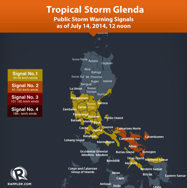
Five of the six Bicol provinces – Camarines Norte, Camarines Sur, Catanduanes, Albay, Sorsogon – are currently under Signal Number 2. These areas should expect to experience winds between 61-100 kilometers per hour in the next 24 hours.
Meanwhile, Signal Number 1 has been raised over these areas:
- Metro Manila
- Batangas
- Cavite
- Laguna
- Rizal
- Bulacan
- Pampanga
- Bataan
- Zambales
- Tarlac
- Nueva Ecija
- Pangasinan
- Southern Aurora
- Masbate
- Marinduque
- Quezon
- Northern Samar
Public Storm Signal No 1 means these areas will experience winds with speeds of 30 to 60 kilometers per hour (km/h) in the next 36 hours.
It is expected to bring moderate to intense (7.5 to 25 millimeters) rain to areas within its 400-kilometer diameter.
It is moving west at a speed of 28 km/h. With its current track, it is expected to make landfall in Catanduanes by Tuesday, July 15, PAGASA said. It will then curve up to the Quezon-Aurora area and traverse Central Luzon, before exiting near western Pangasinan, based on the PAGASA forecast track.
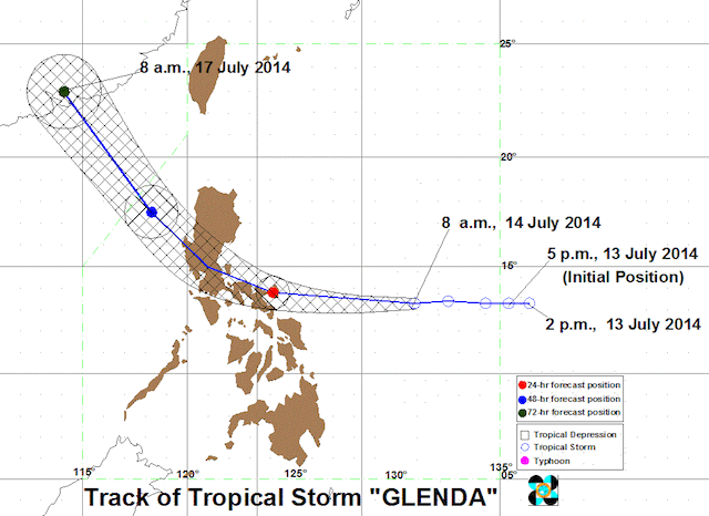
The Japan Meteorological Agency and the US Navy Joint Typhoon Warning Center, meanwhile, are forecasting Glenda/Rammasun to take a path that will pass through the Bicol region, Calabarzon, Metro Manila, and Bataan, before exiting near Zambales towards the West Philippine Sea.
PAGASA says Glenda may still develop into a typhoon as its path takes it across oceans where it may gather strength.
Be ready for hazards
PAGASA warned that the storm will make sea travel risky in the Eastern coasts of Luzon and Visayas.
Flood and landslides are expected in Region III and some areas of Region I and Region II.
PAGASA alerted the public, local government officials and the National Disaster Risk Reduction and Management Council (NDRMMC) to take necessary action to prepare for the weather system’s effects.
Independent weather monitoring agency Weather Philippines said moderate to heavy rains (30 to 55 mm) will likely fall in certain areas in Bicol from Tuesday morning to Wednesday morning. These areas are: Catanduances; Camarines Norte; the towns of Caramoan, Garchitorena and Siruma in Camarines Sur.
PAGASA forecasted that Glenda will be near Infanta, Quezon on Wednesday morning then near Iba, Zambales on Thursday morning.
Glenda is expected to make landfall in Quezon province on Wednesday, July 16. – Rappler.com
Learn how to prepare for the coming storm on Rappler’s Project Agos microsite.
Add a comment
How does this make you feel?
There are no comments yet. Add your comment to start the conversation.