SUMMARY
This is AI generated summarization, which may have errors. For context, always refer to the full article.
What’s the weather like in your area? Tweet us the situation: Use #weatheralert and tag @rapplerdotcom
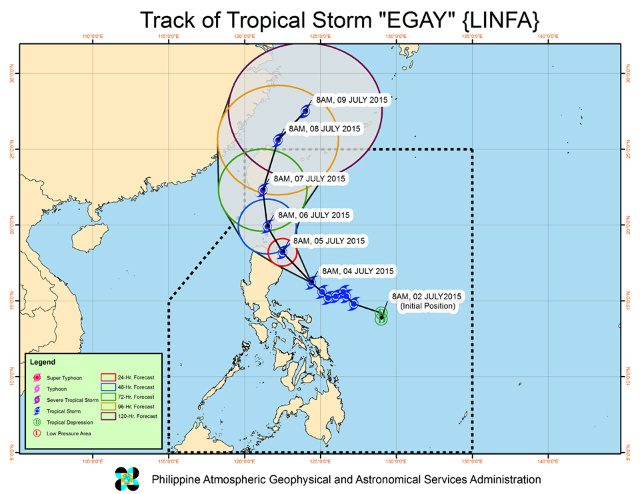
MANILA, Philippines (UPDATED) – Tropical Storm Egay (international name Linfa) has slightly accelerated as it moves closer to Northern Luzon late Saturday morning, July 4.
As of 10 am Saturday, the center of Egay was located at 280 kilometers east northeast of Baler, Aurora. It has maximum sustained winds of 85 km/h near the center, and gustiness of up to 100 km/h. Moderate to occasionally heavy rainfall is expected within its 400-km diameter.
The tropical storm is moving closer to Northern Luzon at a speed of 13 km/h. It is moving northwest in direction.
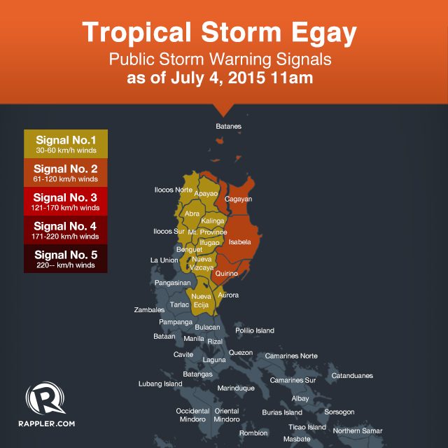
Signal No. 2 is raised over 4 areas:
- Isabela
- Quirino
- Cagayan
- Northern Aurora
State weather bureau PAGASA warned coastal areas under Signal No. 2 of possible storm surges with wave height of 4.1 meters up to 14.0 meters.
Meanwhile, Signal No. 1 is up in the following areas:
- Rest of Aurora
- Nueva Ecija
- Nueva Vizcaya
- Ifugao
- Benguet
- Mt. Province
- Kalinga
- Apayao
- Abra
- Ilocos Norte
- Ilocos Sur
- Babuyan and Calayan Group of Islands
“Fisher folk and small sea crafts are advised not to venture out over the seaboards of Southern Luzon and Visayas and the northern seaboard of Mindanao,” PAGASA said in its Saturday, 11 am bulletin.
Residents living in low-lying and mountainous areas of Metro Manila, Mimaropa, Calabarzon, and Bicol Region should stay alert against possible flashfloods and landslides.
The next bulletin on Egay will be issued at 5 pm Saturday. – Rappler.com
Add a comment
How does this make you feel?
There are no comments yet. Add your comment to start the conversation.