SUMMARY
This is AI generated summarization, which may have errors. For context, always refer to the full article.
BACOLOD CITY, Philippines – The United Nations Educational, Scientific and Cultural Organization (UNESCO) on Wednesday, May 24, declared Bohol Island as a Global Geopark – the first in the Philippines.
It is a seal of recognition of the provincial government’s efforts to rise from the devastation of the magnitude 7.2 earthquake that struck Bohol on October 15, 2013. The earthquake destroyed historic structures and left more than 80,000 people displaced in the region.
The 216th UNESCO Executive Board Session in Paris also declared 17 other geoparks, including those in Brazil, Greece, Indonesia, Iran, Japan, Malaysia, New Zealand, and Norway.
The UN agency defines geoparks as “single, unified geographical areas” where sites and landscapes have international geological significance.
But history isn’t the sole criterion. These sites must also be “managed with a holistic concept of protection, education, and sustainable development,” UNESCO said.
The UNESCO Global Geopark covers 8,808 square kilometers of land surrounding lush marine protected areas. It features wondrous, not-yet-popular karstic geosites like caves, sinkholes, among others.
UNESCO cited Bohol Island’s “400 years of rich history and cultural traditions in harmony with its unique geological treasures.”
Bohol Island joins a network of 195 geoparks from 48 countries.
How it started
Bohol 1st District Representative Edgar Chatto said it has been “a long journey” since they started this “shared dream.”
Chatto recounted that back in 2013, when he was Bohol governor, he met with Mario de los Reyes, former dean of the UP School of Urban and Regional Planning to discuss Bohol’s suitability to become a Global Geopark.
“From when we crafted our vision to become a prime eco-cultural tourism destination, we have resolved to pursue sustainable development through sound environmental management,” Chatto said.
The provincial government and the researchers officially partnered in 2015, working with the Philippine National Commission for UNESCO (UNACOM). It was nominated in 2022 for its geological significance and scientific importance.
Part of Governor Aris Aumentado’s strategic agenda is to make the geopark campaign a priority, as “an inclusive and multi-sectoral platform” to “leverage Bohol’s position as a living laboratory for arts, culture, and heritage in the country and in the region.”
Following the feat, the provincial government expressed gratitude to various public and private sectors, the academe, for helping “make this dream a reality.”
Natural forces
Among the many sites shared by the UNESCO-Philippines Commission are those that show the effects of natural forces like earthquakes on the island’s geology.
The two-kilometer fault scarp in Barangay Anonang in Inabanga town used to be a flat rice field but the earthquake had pushed up the area to become a three-meter-high wall.
“It was caused by a previously unmapped fault, which manifested on the land surface as an elongated fissure on the ground and can be traced for six kilometers” across two barangays. UNESCO’s experts believe the scarp extends even further offshore.
Here are some of the sites at the Bohol Island Geopark.
Danajon Bank Double Barrier Reef
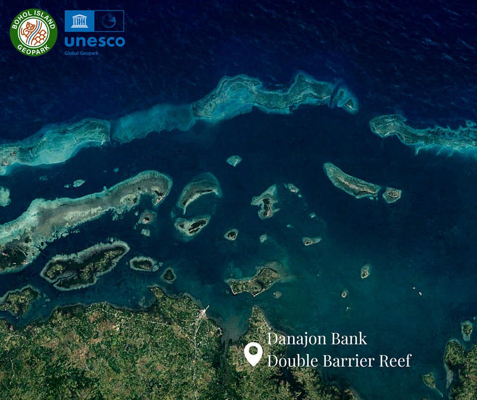
UNESCO calls the Danjon Bank Double Barrier Reef as the only one of its kind in the Philippines and Southeast Asia.
One of only six double barrier reefs in the world, it comprises many “diverse islets and reef patches joining together into an inner Calituban and outer Caubyan barrier reef.”
“Because of its unique coral reef ecology, it is a major breeding ground and habitat of many different species of fishes, marine mammals, mollusks, and seagrasses,” according to UNESCO.
Alicia Panoramic Park

Alicia Panoramic Park features the Binabaje Hills in Barangay Cambaol, Alicia town. The hills, 400 meters above sea level, are mostly covered in cogon, a tropical perennial grass that on windy days gives “a soft furry-like appearance to hills composed primarily of metamorphic rock.”
Alicia Schist, the oldest rock in Bohol, was found in the area. UNESCO said the metamorphic rocks were formed between the Late Jurassic to Early Cretaceous periods.
“It initially started from ocean floor sediments that were successively buried deep underneath layers and layers of sediments until it turned into sedimentary rock. Afterward, it was subjected to tremendous regional pressure and deformation causing its upward movement and eventual emergence from the sea,” UNESCO said.
Princess Manan-aw Cave

Princess Manan-aw Cave is one of the more than 20 caves in the Cagongcagong Cave System located in Barangay Cagongcagong in Alicia town.
Princess Manan-aw Cave is 195 meters long, 5.6 meters high, and 3.7 meters wide at the mouth.
“The caves are a result of the hundreds of thousands of years carving work of water, whether rain or groundwater, on the Sierra Bullones Limestone,” UNESCO said.
Can-umantad Falls

Can-umantad Falls, the highest waterfall in Bohol, is 60 meters in height.
“Its source water from Cadapdapan River falls down over a backdrop of horizontal to slightly dipping beds of calcareous and tuffaceous sediments of a clastic member of the Carmen Formation,” UNESCO said.
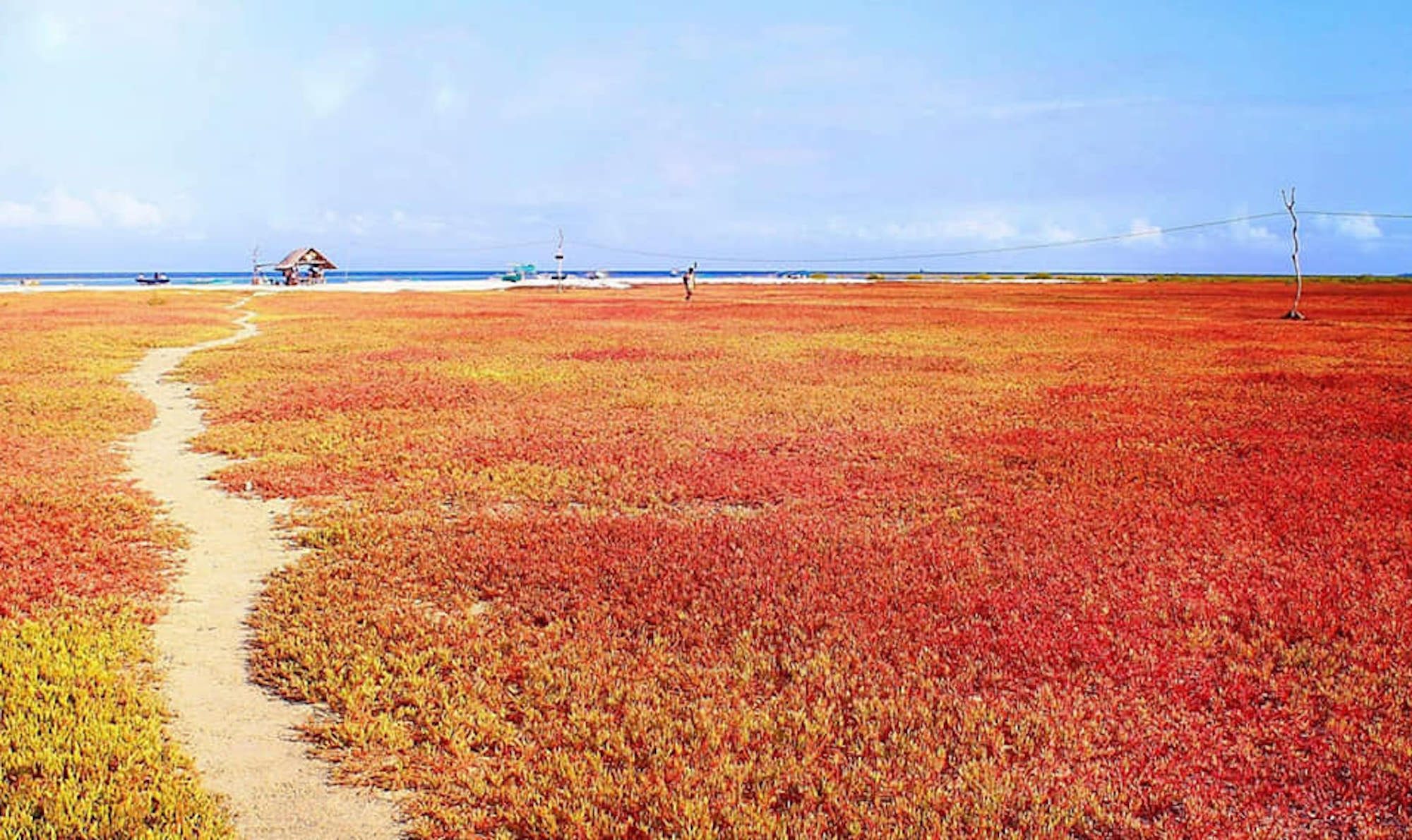
Loon Coastal Geomorphic Conservation Park
The Loon Coastal Geomorphic Conservation Park is one of the shoreline areas that were raised during the 2013 earthquake. It covers an area of 417 hectares.
Now called by locals as the Coral Garden, the former intertidal zone, where the tide sometimes submerged or exposed the land, was pushed up by 1.5 meters as the shoreline shifted 50 meters seaward.
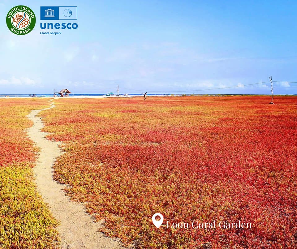
“It is now an uplifted terrace and completely on dry land,” according to UNESCO
While it was barren for years after the quake, it is now teeming with sea purslane, a creeping succulent seagrass plant that is colored red and orange color during sunny days and green color during rainy days.
Maribojoc Uplifted Marine Terrace

UNESCO said that older marine terraces can also be found inland as part of the limestones of Maribojoc Formation.
“They too were a result of tectonic uplift in the not-so-distant geologic past, proof of the immense power of nature to create ever-changing landscapes,” the UN agency said.
Baclayon Marine Terraces
The Baclayon Marine Terraces is similar to that of Maribojoc but much older, dating back to Pliocene-Pleistocene period.
The three-step terraces – 20 meters, 40 meters, and 60 meters above sea level – show at least three episodes of progressive tectonic uplift in the area,” UNESCO said.
“Fault movement along the coast caused the uplift of formerly underwater reefs raising it at a height above the sea and creating a marine terrace along the coast. Several other subsequent fault movements shaped the successive step-like characteristic of the marine terraces,” it said.
Hinagdanan Cave
A farmer clearing his land accidentally stumbled on the Hinagdanan Cave when he dropped a coin into a hole in the ground and he heard a splash. The cave’s name is taken from the ladder – hagdan – that he used to explore the cave.
The cave is about 10 to 20 meters deep with several stalactite and stalagmite formations.
“Aside from its awe-inspiring natural beauty, Hinagdanan also played a significant role in the history of Bohol. The cave was used during Second World War as a hideout by locals to escape from the Japanese Imperial Army,” according to the UNESCO brief.
Canawa Cold Spring
A popular site with locals and surrounded by Candijay town’s forest, the Canawa Cold Spring is so deep that after several attempts, its depth is still unknown, and even the actual source of the spring water remains a mystery.
“The spring is carved out of the Middle Miocene Carmen Formation comprised of 400 to 800 m thick calcareous sedimentary formation,” UNESCO said.
There are concrete walls and stairs at the entrance for those who cannot swim, but the circular pool remains in its natural state.
Cave pools of Anda

The cave pools of Anda are a magnet for adventure seekers because these are basically limestones filled with spring water, forming pools.
Among the famous cave pools are Cabagnow and Combento, and the smaller Kaligoon Cave Pool, East Coast Cave Pool, and Kalorenzo Cave Pool.
“The area is underlain by the Middle Miocene Anda Limestone belonging to the Sierra Bullones Limestone Formation. Years of dissolution and weathering of this limestone body resulted in karst features like these caves,” UNESCO said.
Lamanok Island
Lamanok island is made up of massive limestone deposits of the Late Miocene Sierra Bullones Formation.
“Prominent tidal notches can be observed around the edge of the island facing Bohol Sea showing dynamic movement of the sea during the Neogene Period. Large fossils such as giant shells protrude out of the limestone outcrops and cave walls,” according to UNESCO.
It also noted that “this section of the Anda Peninsula is also considered the seat of Bohol’s civilization as archaeological artifacts and burial sites of ancient settlers are preserved.”
Batungay Cave
It is one of a number of caves in Trinidad, a town on Bohol’s northern flank.
Batungay Cave is in the forest of Barangay Santo Tomas, and its name means twin rocks, as the cave is beneath two solid rocks known as Batungay Twin Peak.
“Inside the cave is a flowing stream of clear water and majestic stalactites hanging from the cave ceiling and stalagmites jutting out from the cave floor forming different shapes like chandeliers and curtains,” according to the UNESCO
Here are the other UNESCO Global Geoparks:
– Inday Varona with reports from Iya Gozum/Rappler.com
Add a comment
How does this make you feel?
There are no comments yet. Add your comment to start the conversation.