SUMMARY
This is AI generated summarization, which may have errors. For context, always refer to the full article.
. Max winds/gust (160/195kph). Moving West Northwest @ 20kph. Image courtesy of PAGASA.")
MANILA, Philippines (UPDATED) – Typhoon Pablo (Bopha) continued to batter Mindanao Tuesday, December 4, even as it weakened after making landfall earlier in the day, leaving more than 40,000 people in evacuation centers.
More than 40,000 people crammed into shelters to escape the onslaught of the strongest typhoon to hit the country this year.
In its 6 a.m. report, the National Disaster Risk Reduction and Management Council (NDRRMC) said a total of 8,283 families or 41,608 persons preemptively evacuated in Regions 8, 10, 11 and 13, specifically in the provinces of Leyte, Surigao provinces, Agusan del Norte, Misamis Oriental, Lanao del Norte and Davao Oriental.
Majority of the evacuees were in the Surigao provinces, both in direct path of the typhoon.
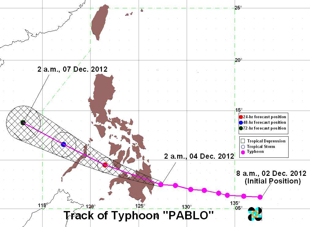
After making landfall, the typhoon is now raking across the island of 10 million people, packing gusts of up to 210 kilometers (130 miles) an hour and bringing heavy rain.
The typhoon, labeled as a super typhoon by foreign weather bureaus, made landfall carrying maximum sustained winds of 175 km/h, and gusts of up to 210 km/h. The eye of the typhoon arrived ashore between 4:30 am and 5 am.
The typhoon’s center was spotted in the vicinity of Malaybalay City in Bukidnon (8.3°N 125.0°E) as of 11 am Tuesday, carrying maximum sustained winds of 160 km/h and gusts of up to 195 km/h.
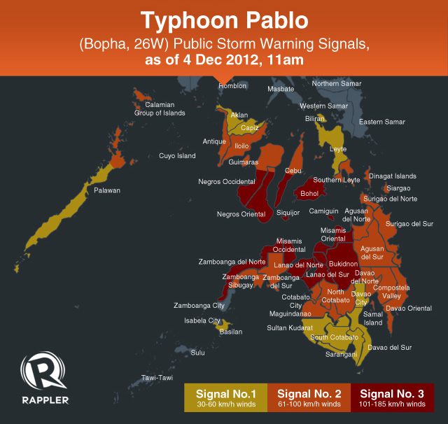
The bureau has raised the following storm signals over the following areas:
Public Storm Warning Signal #3
(Winds of 101-185 km/h expected in at least 18 h)
- Misamis Oriental
- Misamis Occidental
- Bukidnon
- Lanao del Sur
- Lanao del Norte
- Zamboanga del Norte
- Camiguin
- Bohol
- Siquijor
- Southern Cebu
- Southern Negros Occidental
- Southern Negros Oriental
Signal #2
(Winds of 61-100 km/h expected within the next 24 h)
- Northern Palawan incl Cuyo, Calamian islands
- Southern Leyte
- Antique
- Iloilo
- Guimaras
- Rest of Cebu
- Rest of Negros Oriental
- Rest of Negros Occidental
- Surigao del Norte
- Surigao del Sur
- Siargao
- Dinagat Island
- Agusan del Sur
- Agusan del Norte
- Davao del Norte inc Samal
- Compostela Valley
- Davao Oriental
- North Cotabato
- Zamboanga del Sur
- Zamboanga Sibugay
Signal #1
(Winds of 45-60 km/h expected within the next 36 h)
- Rest of Palawan
- Aklan
- Capiz
- Leyte
- Biliran
- Davao del Sur
- South Cotabato
- Basilan
- Sarangani
- Sultan Kudarat
Heavy to intense rainfall (10-20 mm/h) is expected within the typhoon’s 500 km diameter, state weather bureau PAGASA said.
Pablo has slowed down, moving at a speed of 20 km/h, and is taking a path toward the west northwest.
PAGASA forecasts Pablo to traverse Mindanao through the day, exiting the island through Misamis Oriental and moving on to the southern tip of Negros Island.
It will then continue towards the Sulu Sea before crossing Palawan on its way to the West Philippine Sea (South China Sea) by Friday.
“Residents living in low lying and mountainous areas under public storm warning signals are alerted against possible flashfloods and landslides,” the bureau said.
“Likewise, residents in coastal areas under public storm warning signal #2 and signal #3 are alerted against storm surges particulary those living in the coastal areas of Surigao del Sur, Surigao del Norte, Dinagat, Bohol and Leyte provinces where 3-6 meters wave height is expected,” the bureau added.
Seacraft are advised to stay onshore, particularly in the eastern seaboard of Visayas and Mindanao.
Mindanao in lockdown
There were no immediate reports of casualties or serious damage but Mindanao was in lockdown with residents of coastal and flood-prone areas moving into shelters as floods hit some areas.
Aviation and shipping were suspended, with 80 flights grounded and thousands of ferry passengers stranded at ports as the coastguard ordered vessels to stay in port, the civil defense office said.
More than 41,000 people had moved into nearly 1,000 government shelters across the island by early Tuesday, it said in its latest bulletin.
The commercial center of Cagayan de Oro, one of Mindanao’s largest cities, was hit by flooding as rivers overflowed following heavy rain.
School holidays were declared in Mindanao and large areas of the central Philippines.
President Benigno Aquino led calls for evacuations on Monday, saying: “Pablo’s destructive potential is no laughing matter. It is expected to be the strongest typhoon to hit our country in 2012.”
The Philippines is battered by about 20 typhoons a year, some of them destructive. Pablo is the sixteenth so far this year.
In August, nearly 100 people were killed and more than a million were displaced by heavy flooding caused by a series of storms.
Nineteen typhoons struck the country last year, of which 10 were destructive, leading to more than 1,500 deaths and affecting nearly 10 percent of the total population, according to the government. – Rappler.com/ Agence France-Presse
Add a comment
How does this make you feel?
There are no comments yet. Add your comment to start the conversation.