SUMMARY
This is AI generated summarization, which may have errors. For context, always refer to the full article.

What’s the weather like in your area? Tweet us at @rapplerdotcom.
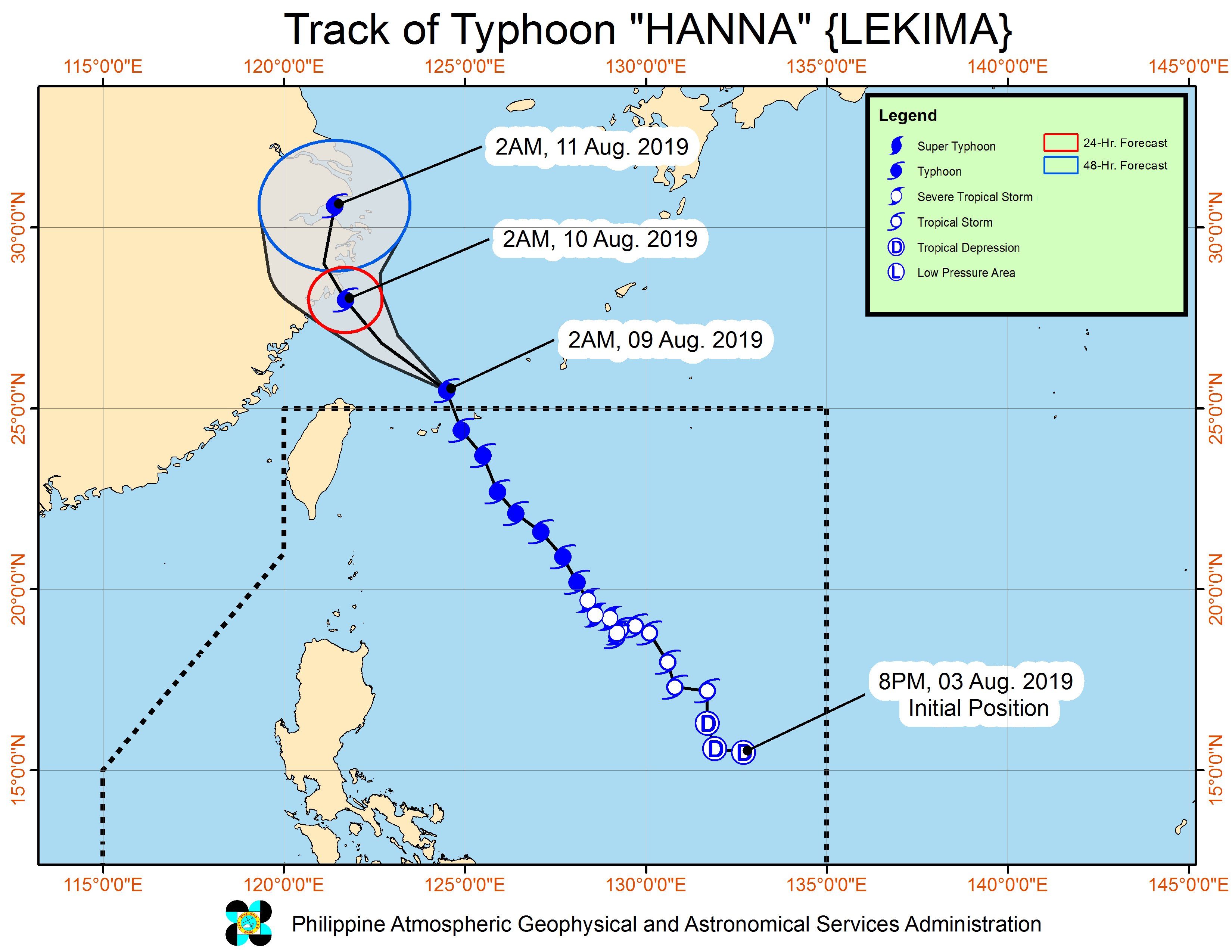
MANILA, Philippines (UPDATED) – Typhoon Hanna (Lekima) left the Philippine Area of Responsibility (PAR) at 12:30 am on Friday, August 9, but it continues to enhance the southwest monsoon or hanging habagat.
The Philippine Atmospheric, Geophysical, and Astronomical Services Administration (PAGASA) announced Hanna’s exit through social media at around 1 am on Friday.
It then released the final bulletin on the typhoon at 5 am, saying that Hanna is already 645 kilometers north northeast of Basco, Batanes. It slightly accelerated, now moving north northwest at 20 kilometers per hour (km/h) from the previous 15 km/h.
The typhoon slightly weakened after it left PAR. It now has maximum winds of 175 km/h from the previous 195 km/h and gustiness of up to 215 km/h from the previous 240 km/h.
Hanna’s outer rainbands had affected Batanes and the Babuyan Group of Islands, which were previously placed under Signal No. 1. But it did not make landfall in the Philippines.
Hanna was the Philippines’ 8th tropical cyclone for 2019, and the 1st for the month of August. It is also the country’s 1st tropical cyclone to reach typhoon status in 2019. (READ: LIST: PAGASA’s names for tropical cyclones in 2019)
Even with Hanna gone, however, there’s still the southwest monsoon. Below is the latest list of affected areas.
Friday, August 9
- Moderate to heavy monsoon rain
- Ilocos Region
- Cordillera Administrative Region
- Batanes
- Babuyan Group of Islands
- Zambales
- Bataan
- Occidental Mindoro
- northern part of Palawan including Calamian Islands
- Light to heavy monsoon rain
- Metro Manila
- Calabarzon
- rest of Central Luzon
- rest of Mimaropa
- Western Visayas
Saturday, August 10
- Light to heavy monsoon rain
- Ilocos Region
- Cordillera Administrative Region
- Zambales
- Bataan
PAGASA advised residents to stay on alert for possible flash floods and landslides. Gusty conditions will also continue in most of Luzon and the Visayas due to the enhanced southwest monsoon. (READ: FAST FACTS: Tropical cyclones, rainfall advisories)
Some areas suspended classes for Friday. (READ: #WalangPasok: Class suspensions, Friday, August 9, 2019)
Travel remains risky in the seaboards of Luzon and the Visayas, and northern and eastern seaboards of Mindanao.
PAGASA also continues to monitor Typhoon Krosa, which is located outside PAR.
Krosa is now 1,990 kilometers east of extreme Northern Luzon, slowly moving east. It maintained its strength, with maximum winds of 155 km/h and gustiness of up to 190 km/h.
It is not expected to enter PAR.
The country gets an average of 20 tropical cyclones annually, but since 2019 is an El Niño year, only 14 to 18 tropical cyclones are expected.
Below is the estimated number of tropical cyclones from August to December:
- August – 2 to 4
- September – 2 to 4
- October – 2 or 3
- November – 1 or 2
- December – 0 or 1
PAGASA declared the start of the rainy season last June 14. – Rappler.com
Add a comment
How does this make you feel?
There are no comments yet. Add your comment to start the conversation.