SUMMARY
This is AI generated summarization, which may have errors. For context, always refer to the full article.
What’s the weather like in your area? Tweet us at @rapplerdotcom.
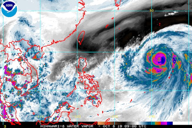
MANILA, Philippines – The state weather bureau continues to monitor Typhoon Hagibis, which is still outside the Philippine Area of Responsibility (PAR).
In a briefing at 4 pm on Tuesday, October 8, the Philippine Atmospheric, Geophysical, and Astronomical Services Administration (PAGASA) said Hagibis is already 2,250 kilometers east of Central Luzon.
It is moving northwest at 25 kilometers per hour (km/h).
The typhoon now has maximum winds of 200 km/h from the previous 175 km/h a day ago, and gustiness of up to 245 km/h from the previous 215 km/h.
PAGASA Weather Specialist Aldczar Aurelio said Hagibis, if it maintains its direction, might just pass through the right corner of PAR.
If that happens, Aurelio said, Hagibis would only be inside PAR for less than a day.
When Hagibis enters PAR, it will be given the local name Perla. (READ: LIST: PAGASA’s names for tropical cyclones in 2019)
PAGASA earlier said Hagibis or the potential Perla could enter PAR by Friday, October 11.
In the meantime, fair weather will persist in the entire country on Wednesday, October 9. But isolated rainshowers or thunderstorms are expected, especially in the afternoon or evening. (READ: FAST FACTS: Tropical cyclones, rainfall advisories)
The Philippines has had 15 tropical cyclones in 2019.
The country gets an average of 20 tropical cyclones annually, but since 2019 is an El Niño year, only 14 to 18 tropical cyclones are expected.
Below is the estimated number of tropical cyclones from October to December:
- October – 2 or 3
- November – 1 or 2
- December – 0 or 1
PAGASA declared the start of the rainy season last June 14. – Rappler.com
Add a comment
How does this make you feel?
There are no comments yet. Add your comment to start the conversation.