SUMMARY
This is AI generated summarization, which may have errors. For context, always refer to the full article.
What’s the weather like in your area? Tweet us at @rapplerdotcom.
MANILA, Philippines – The state weather bureau urged local government units and the public to be vigilant even while celebrating the Christmas season, as Tropical Storm Ursula (Phanfone) is expected to hit land on Christmas Eve.
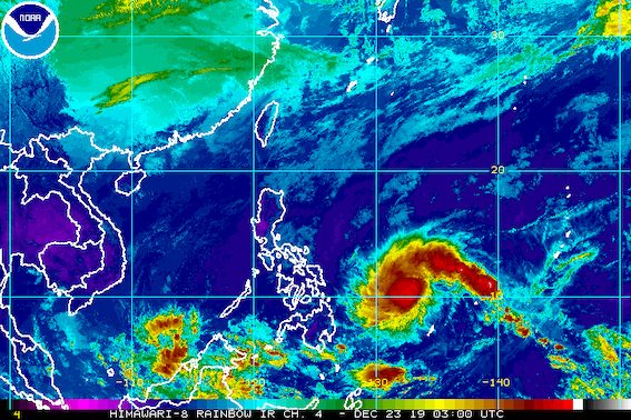
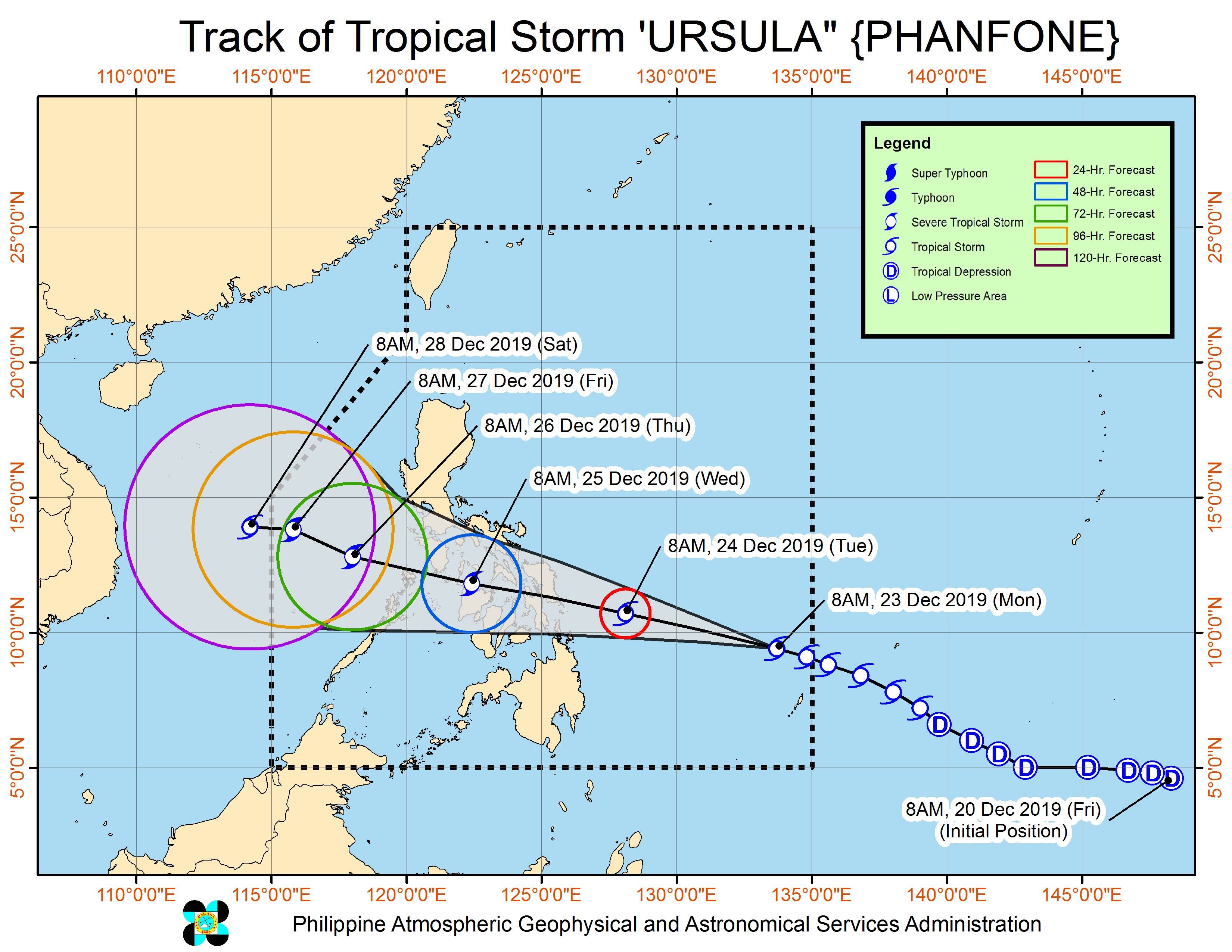
In a briefing past 11 am on Monday, December 23, the Philippine Atmospheric, Geophysical, and Astronomical Services Administration (PAGASA) said Ursula is now 790 kilometers east northeast of Hinatuan, Surigao del Sur, or 870 kilometers east of Surigao City, Surigao del Norte.
The tropical storm slightly accelerated, now moving west northwest at a relatively fast 30 kilometers per hour (km/h) from the previous 25 km/h.
Ursula maintained its strength on Monday morning, with maximum winds of 65 km/h and gustiness of up to 80 km/h. But it is likely to intensify into a severe tropical storm before making landfall.
Ursula is forecast to make landfall in Eastern Visayas on Tuesday afternoon or evening, December 24, Christmas Eve.
“Maaaring festive mood tayong muli…. Maaari pong tayo’y magno-noche buena pagdaan ng bagyo…. Kailangan po tayong magbantay…maging vigilant po tayo,” said Esperanza Cayanan, weather services chief of PAGASA’s Weather Division.
(We may be in a festive mood. We may be having noche buena as the tropical storm hits. But we need to stay on guard, we should be vigilant.)
More areas have been placed under Signal No. 1 as of Monday morning:
- Sorsogon
- Masbate including Ticao Island
- Eastern Samar
- Northern Samar
- Samar
- Biliran
- Leyte
- Southern Leyte
- northern part of Cebu (Carmen, Asturias, Tuburan, Catmon, Sogod, Borbon, Tabuelan, Tabogon, San Remigio, Bogo, Medellin, Daanbantayan, Bantayan Island, Camotes Islands)
- central part of Cebu (Balamban, Talisay, Cebu City, Cordova, Lapu-Lapu, Mandaue, Consolacion, Liloan, Compostela, Danao)
- northeastern part of Bohol (Inabanga, Danao, Dagohoy, Pilar, Guindulman, Anda, Candijay, Alicia, Buenavista, Jetafe, Talibon, Trinidad, Bien Unido, San Miguel, Ubay, Mabini, President Carlos P Garcia)
- Dinagat Islands
- Surigao del Norte including Siargao Island
Signal No. 1 means winds of 30 km/h to 60 km/h are expected. PAGASA said strong winds may begin to affect Eastern Visayas and the northeastern part of Mindanao on Tuesday morning, as well as the southern part of Bicol and some portions of Central Visayas on Tuesday afternoon.
The strong winds “may bring light damage to medium to high-risk structures.” (READ: Why is it now called tropical cyclone ‘wind’ – and not ‘warning’ – signals?)
Aside from the winds, Ursula will also bring heavy rain. From Tuesday to Wednesday morning, December 25, expect the following:
Moderate to heavy rain
- Dinagat Islands
- Siargao Island
- Bucas Grande Island
- Eastern Visayas
- Sorsogon
- Masbate
- Romblon
- Aklan
- Antique
- Capiz
- Iloilo
- Guimaras
- northern part of Cebu
- northern part of Negros Occidental
Light to moderate rain with intermittent heavy rain
- Quezon
- rest of Bicol
- rest of the Visayas
- rest of Surigao del Norte
Flash floods and landslides are possible. (READ: FAST FACTS: Tropical cyclones, rainfall advisories)
“Beginning today (Monday), dapat may ugnayan na po ‘yung local community (the local community should already have coordination) with the local government officials,” said PAGASA Senior Weather Specialist Chris Perez.
The state weather bureau added that moderate to rough seas will prevail over the Philippines’ eastern seaboards on Monday.
Sea conditions could worsen beginning Monday night or Tuesday morning, as rough to very rough seas may be experienced in the northern and eastern seaboards of Bicol and the eastern seaboards of Eastern Visayas and Caraga. Travel will be risky, especially for those using small vessels.
Maritime trips in areas under tropical cyclone wind signals are expected to be canceled.
Based on its latest forecast track, Ursula is expected to leave the Philippine Area of Responsibility on Friday, December 27.
Ursula is the Philippines’ 21st tropical cyclone for 2019, exceeding the yearly average of 20. (READ: LIST: PAGASA’s names for tropical cyclones in 2019)
Ursula is also the second tropical cyclone for December, after Typhoon Tisoy (Kammuri). PAGASA earlier said it was expecting one or two tropical cyclones during the month.
In December 2018, the Philippines had a deadly tropical cyclone during Christmas – Tropical Depression Usman. It left 156 people dead and 105 others injured in Eastern Visayas, Bicol, and Mimaropa, according to the National Disaster Risk Reduction and Management Council.
PAGASA declared the start of the rainy season last June 14. – Rappler.com
Add a comment
How does this make you feel?
There are no comments yet. Add your comment to start the conversation.