SUMMARY
This is AI generated summarization, which may have errors. For context, always refer to the full article.

MANILA, Philippines – The tropical depression outside the Philippine Area of Responsibility (PAR) is now “struggling” to maintain its strength while moving “erratically,” the country’s weather bureau said late Monday, November 13.
In an advisory released past 11 pm on Monday, the Philippine Atmospheric, Geophysical, and Astronomical Services Administration (PAGASA) said the tropical depression was last spotted 1,655 kilometers east of southeastern Mindanao, or over the waters east of the island nation of Palau.
It is moving southeast at a slower 10 kilometers per hour from the previous 20 km/h.
So far, it continues to have maximum sustained winds of 45 km/h and gustiness of up to 55 km/h.
PAGASA now sees the tropical depression maintaining its erratic movement and lingering “near or around its present position in the next 12 to 24 hours,” or until Tuesday, November 14, “as it remains highly disorganized.”
Then the tropical depression could speed up toward the west or west northwest, and enter PAR late Wednesday, November 15, or early Thursday, November 16.
It will be given the local name Kabayan once it enters PAR.
Inside PAR, it may keep moving west until Friday, November 17, “when it is expected to turn more northwestward over the waters east of Mindanao,” PAGASA said.
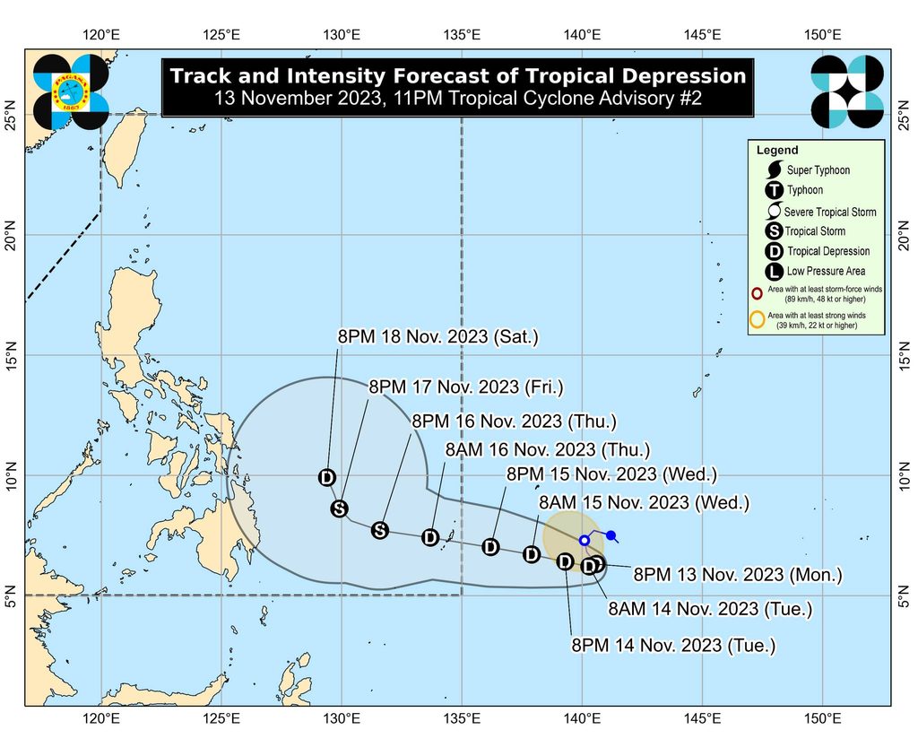
In the next 24 to 36 hours or until mid-Wednesday at the latest, an “unfavorable environment” could prevent the tropical depression from maintaining its strength or intensifying.
“There is an increasing possibility that this tropical cyclone may weaken into a low pressure area in the next 12 to 24 hours,” PAGASA said.
But there may be “some limited intensification by Wednesday, allowing the system to reach tropical storm category by Thursday.”
Afterwards, however, it could be downgraded back to a tropical depression by Saturday, November 18, due to the possible surge of the northeast monsoon or amihan. Tropical cyclones usually weaken when they come into contact with cold, dry air.
PAGASA earlier said in its initial forecast on Monday morning that the tropical depression may reach typhoon status.
Though its Monday evening forecast indicated a weaker tropical cyclone, the weather bureau emphasized that “regardless of its development trend, the interaction between this tropical cyclone and a possible shear line related to the forecast surge of the northeast monsoon” could trigger heavy rain.
PAGASA warned that the eastern part of Mindanao might see heavy rain starting Friday, while Bicol and most of the Visayas are seen to have similar conditions beginning Saturday.
ALSO ON RAPPLER
- ‘Freedom,’ Leila de Lima says after being granted bail
- ‘I cannot control my tears,’ says archbishop as De Lima walks free
- Camille Rodriguez delighted with growth of PH women’s football as Kaya FC rules
For coastal waters, the northeast monsoon is expected to cause rough to very rough seas in most seaboards of Luzon and the eastern seaboard of the Visayas in the next five days.
The tropical cyclone will also trigger moderate to rough seas in the eastern seaboard of Mindanao starting Friday.
“Mariners of small seacraft, especially of motor bancas and similarly-sized vessels, are advised to continue monitoring for updates,” PAGASA said.
The incoming tropical cyclone will be the Philippines’ 11th tropical cyclone for 2023 and the first for November. The weather bureau earlier estimated that one or two tropical cyclones could enter or form within PAR during the month. – Rappler.com
Add a comment
How does this make you feel?
There are no comments yet. Add your comment to start the conversation.