SUMMARY
This is AI generated summarization, which may have errors. For context, always refer to the full article.
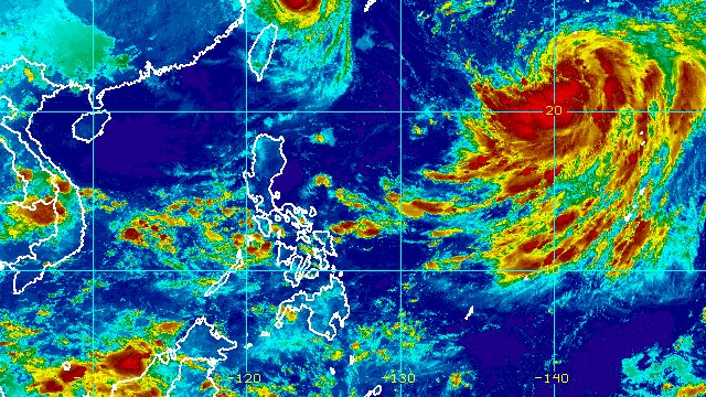
MANILA, Philippines – The tropical depression outside the Philippine Area of Responsibility (PAR) strengthened into a tropical storm at 2 am on Wednesday, September 14, and was given the international name Nanmadol.
The Philippine Atmospheric, Geophysical, and Astronomical Services Administration (PAGASA) said in its 5 am advisory on Wednesday that Tropical Storm Nanmadol now has maximum sustained winds of 65 kilometers per hour and gustiness of up to 80 km/h.
PAGASA added that Nanmadol is expected to further intensify on Thursday, September 15, and it may eventually enter PAR as a typhoon.
In the early hours of Wednesday, Nanmadol was located 1,910 kilometers east of extreme Northern Luzon, moving east northeast at only 10 km/h.
The weather bureau said the tropical storm will move generally northeast in the next several hours before “sharply turning” northwest for the rest of the day.
Then Nanmadol could speed up west northwest from Thursday to Friday, September 16, toward the northeastern part of PAR.
It may enter PAR on Thursday evening or Friday morning, and would be given the local name Josie.
PAGASA said Nanmadol or the potential Josie is expected to stay far from Philippine landmass, which means it will not directly affect weather in the country.
But it could enhance the southwest monsoon or hanging habagat, which may trigger monsoon rain in the western parts of Southern Luzon and the Visayas starting Wednesday or Thursday.
PAGASA Weather Specialist Grace Castañeda said the southwest monsoon was still weak but could bring scattered rain showers and thunderstorms to these areas on Wednesday:
- Occidental Mindoro
- Palawan
- Aklan
- Antique

Nanmadol or the potential Josie would be the Philippines’ 10th tropical cyclone for 2022.
It would also be the second tropical cyclone for September, after Typhoon Inday (Muifa), which did not make landfall.
PAGASA expects 7 to 11 tropical cyclones to enter or develop inside PAR from September 2022 to February 2023. Per month, these are the weather bureau’s estimates:
- September 2022 – 2 or 3
- October 2022 – 2 to 4
- November 2022 – 2 or 3
- December 2022 – 1 or 2
- January 2023 – 0 or 1
- February 2023 – 0 or 1
– Rappler.com
Add a comment
How does this make you feel?
There are no comments yet. Add your comment to start the conversation.