SUMMARY
This is AI generated summarization, which may have errors. For context, always refer to the full article.
MANILA, Philippines – It was 10 minutes past midnight of August 17, 1976, a Tuesday.
While most people were sleeping, a massive earthquake, registering magnitude 8.0 on the Richter scale, rocked most of Mindanao and parts of the Visayas.
The tremor was most strongly felt in the cities and towns surrounding the Moro Gulf, particularly in Cotabato City, which now hosts the regional center of the Autonomous Region in Muslim Mindanao (ARMM).
What made the 1976 Moro Gulf Quake most devastating, however, was not just the degree of the earth shaking.
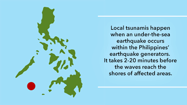
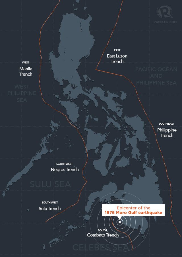
With its epicenter near the town of Lebak in Sultan Kudarat, in a region of the Celebes Sea where earthquakes frequently occur – the 1976 Moro Gulf quake brought with it one of the most terrifying natural forces known to man: a tsunami. (READ: Tsunami 101: What you need to know about tsunamis)
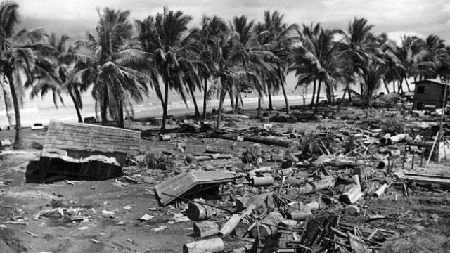
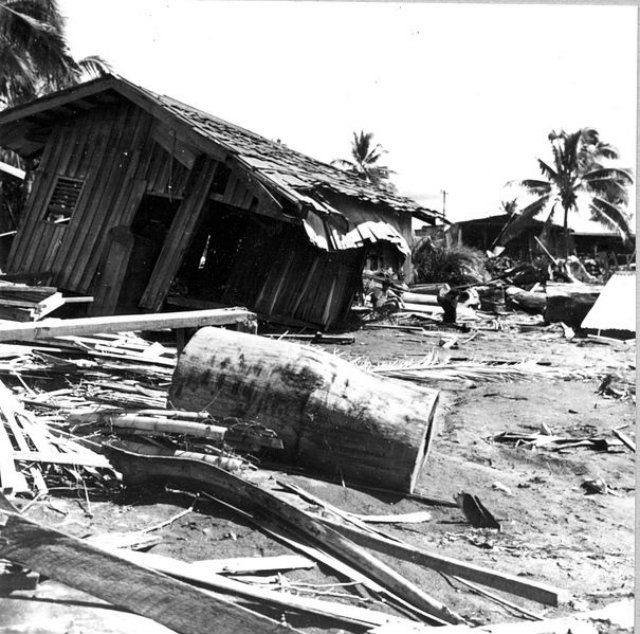
Without warning, about 2-5 minutes after the earthquake struck, waves as high as 9 meters reached the shore and inundated communities along the Moro Gulf.
The tsunami affected 700 kilometers of coastline, with Pagadian City, Cotabato City, Zamboanga City, and Lebak in Sultan Kudarat experiencing the highest waves.
About 8,000 people died, including those missing and were never found, making it the most disastrous tsunami to hit the Philippines.
It is more than the number of casualties recorded after Super Typhoon Yolanda, the strongest typhoon in the world, hit the country.
Eyewitness accounts
In the report Moro Gulf Tsunami of 17 August 1976, Fr Victor Badillo and Zinnia Astilla of the Manila Observatory for the Special Committee on Tsunami Warning System gathered the following statements:
“A housewife of Pagadian City said that at about 12:15am, the earth started to move. She woke her 10 children up to evacuate to higher grounds knowing that a tidal wave would follow a powerful tremor. Five minutes later, giant waves roared half-a-kilometer inland washing away hundreds of houses along the coast.”
– from the Philippine Daily Express
“I couldn’t stand up, I was dizzy and nauseated on feeling the earthquake. After a while talking with fear-striken people I went to my room but came down at once upon hearing a loud rumbling like many trucks together. Someone shouted it was the surf. The noise had been the roar of a giant wave which swept little huts on stilts.”
– from the Asian Report
“We were asleep. I woke up as the house rocked like a boat caught in a storm… We all rushed out of the house… for safer ground. Seconds after, the killer wave engulfed our house. It was a nightmare beyond belief.”
– from Warlito Fausto, a 33-year-old route helper
Midnight killer
Philippine Institute of Volcanology and Seismology (Phivolcs) director Renato Solidum said the high number of deaths – many of whom were children – could be attributed to the time the tsunami struck and the number of people residing near the shore at that time.
“Many people lived near the coast. Also, it was very dark. [It was] past midnight… Why many [died]? It’s because it was sudden. If it happened in the morning when children are in school, a lot of people would probably be able to run for their lives,” Solidum explained.
It’s important to note the type of the tsunami, he added. “It was a local tsunami. The onset of the first event (wave) occurred 2 to 5 minutes after the earthquake. Definitely, the height of the wave would matter in terms of the number of deaths.”
While the earthquake caused fire and some buildings to collapse, the tsunami caused most of the damage.
The massive devastation brought by the Moro Gulf earthquake and the tsunami that followed resulted in a change in the country’s disaster preparedness plans. It also led then president Ferdinand Marcos to revise the provisions of the National Building Code a year after the tragedy.
In 1978, Marcos created the National Disaster Coordinating Council, the predecessor of what is now known as the National Disaster Risk Reduction and Management Council. (READ: FAST FACTS: the NDRRMC)
Tsunami generators in PH
The Philippines is more vulnerable to geological hazards such as earthquakes and tsunamis, according to the Phivolcs, due to its geography as an archipelago located along the Pacific Ocean’s Ring of Fire.
Located along every side of the Philippine archipelago are different trenches that can generate tsunamis should the trenches move enough to create an earthquake.
 According to Solidum, tsunamis in the Philippines are more dangerous compared to those that occur in other countries such as Indonesia and Japan.
Add a comment
How does this make you feel?
There are no comments yet. Add your comment to start the conversation.