SUMMARY
This is AI generated summarization, which may have errors. For context, always refer to the full article.
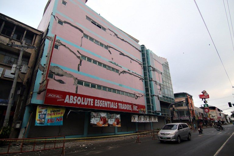
MANILA, Philippines – The Philippine Institute of Volcanology and Seismology (Phivolcs) said aftershocks continue to rock Surigao City, two days after the strong earthquake that left at least 6 people dead.
The epicenter of the tremor was located 16 kilometers (km) offshore, northwest of Surigao City, Surigao Strait at a depth of 10 km. It was generated by the movement of the Surigao segment of the Philippine Fault.
But what exactly is the situation in the affected areas? What can we expect from the aftershocks? What should the residents do to keep their families and communities safe? (READ: #EarthquakePH: What to do during aftershocks?)
On Sunday evening, February 12, Phivolcs Director Renato Solidum talked to MovePH, Rappler’s civic engagement arm that operates the disaster platform eBayanihan, to discuss the science behind the earthquake and how the quake-hit areas should deal with the disaster.
Below is a primer that Phivolcs prepared to explain this latest quake to the public.
What is happening in Surigao del Norte?
Based on preliminary intensity reports, the strongest ground shaking was felt at Phivolcs Earthquake Intensity Scale (PEIS) VII (Destructive) in Surigao City. Furthermore, the municipalities of Pintuyan in Southern Leyte, and San Francisco and Malimono in Surigao del Norte experienced the ground shaking at PEIS VI (Very Strong), while the municipalities of Mainit and Placer in Surigao del Norte, Libjo and San Jose in Dinagat Island, San Ricardo, Limasawa and San Francisco in Southern Leyte and Manduae City felt the shaking at PEIS V (Strong). This earthquake was felt PEIS IV to I as far as 250 km away (Butuan City, Ormoc City, Tacloban City, Catbalogan City, Bislig City, Cebu City, Cagayan de Oro City, Dumaguete City, and Tagbilaran City) from the epicentral area. The strong ground shaking near the epicentral area resulted to damage to some buildings, roads, and bridges.
Large earthquakes have affected Surigao del Norte in the past.
On July 1, 1879, a magnitude 7.4 earthquake was generated by the movement of the Surigao segment of the Philippine Fault. This earthquake was considered to be the largest historical earthquake in this area. During this event, strong ground shaking was felt in Surigao del Norte and caused significant damage to churches, buildings, and roads. A surface rupture, as well as widespread liquefaction and landslides, were also documented.
Why do earthquakes occur in Surigao del Norte?
Eastern Mindanao, including Surigao del Norte, is one of the seismically active areas in the country because of the Philippine Fault and Philippine Trench, which are the main earthquake generators that can affect the area. In addition, there are other local faults which can be sources of small- to large-magnitude earthquakes.
Can these present earthquakes indicate volcanic activity?
No. There are no active volcanoes in the epicentral area.
What can we expect from the current earthquake activity?
The current seismic trend indicates that the magnitude 6.7 earthquake on February 10, 2017 is the main shock, which caused the strong ground shaking. The succeeding small-magnitude earthquakes are the aftershocks. The aftershocks may continue to occur for several days to weeks, some of which may be felt. However, the probability of an earthquake higher than magnitude 6.7 to occur is low.
Aside from strong ground shaking, what other seismic hazards are life-threatening?
Landslides, rock falls, and other types of mass movements may occur in mountainous or hilly areas. Liquefaction, manifested by sand boils or lateral spread may affect low-lying, water-logged, sandy areas at the banks of rivers. Tsunami is not expected from the kind of movement of the Philippine Fault – Surigao segment. The tsunami threat for Surigao del Norte would come from the movement of the Philippine Trench, located east of the province.
What should be done by the affected communities?
People are reminded to be cautious of structures visibly weakened or with signs of damage, as these may be further damaged by aftershocks. In case of houses and other buildings with visible damage, it is best to contact the Municipal/City Engineering Office for advice. Engineers from the local government, other agencies, and organizations should inspect buildings and other infrastructure to determine their integrity, and recommend appropriate actions to concerned affected groups or individuals. Slopes should be checked for tension cracks that may have resulted from the strong ground shaking. Tension cracks may make slopes more susceptible to landslides. These areas should be avoided.
The best course of action is preparedness. In case of another felt earthquake, it is recommended that people protect themselves by doing the “duck, cover, and hold.” In homes and offices, heavy furniture should be strapped to the walls, and appliances be secured to prevent them from toppling and causing injuries to persons.
What is the role of Phivolcs?
Phivolcs operates and maintains a network of 92 seismic stations spread across the Philippines. Data from the seismic stations are used to determine the location, magnitude, and other characteristics of the earthquakes generated.
The closest seismic stations to Surigao del Norte are the Surigao City (Surigao del Norte) and Bislig (Surigao del Sur) staff-controlled (manned) seismic stations, and the Maasin (Southern Leyte), General Luna (Surigao del Norte) and Butuan City (Agusan del Norte) remote-telemetered seismic stations.
Aside from monitoring the occurrences of earthquakes, Phivolcs also conducts hazards analyses and assessments, and makes this information available to the public. Phivolcs works hand-in-hand with other government agencies in mitigating the damaging effects of earthquakes.
Please visit the website of Phivolcs at http://www.phivolcs.dost.gov.ph, and its Facebook and Twitter accounts for earthquake bulletins, volcano updates, hazard maps, and other information on earthquakes and volcanoes. Earthquake observations may also be reported to Phivolcs at telephone numbers (02) 929-9254 and (02) 426-1468 to 79, local numbers 124 and 125. – Rappler.com
Add a comment
How does this make you feel?
There are no comments yet. Add your comment to start the conversation.