SUMMARY
This is AI generated summarization, which may have errors. For context, always refer to the full article.
MANILA, Philippines – How do you know your area is hazard-prone?
The Philippine Institute of Volcanology and Seismology (Phivolcs) has come up with an application that can give you that information on Tuesday, July 16, the anniversary of the 1990 Luzon earthquake.
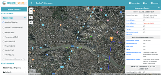
Named HazardHunterPH, the web application is used to generate assessment reports on the user’s location, featuring a summary of seismic (earthquake), volcanic, and hydro-meteorological hazards, along with explanations and recommendations. (WATCH: What can you do to prepare for disasters?)
This means people can see if their chosen location is prone to floods or is near an active fault, among others. (READ: How to know if your area is near a fault line)
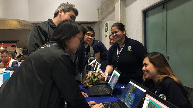
Users will just have to type the location in the search bar of HazardHunterPH’s website, and double-click or tap on the map to select the target area.
The hazard assessment report can be accessed after 15 seconds, with trivia about earthquakes and other relevant topics being shown during the waiting period. A full report can also be seen by clicking on the view explanation and recommendation link in the initial report.
“This technology arises from the need for everyone to be aware of the hazards and potential impacts in our communities,” said Department of Science and Technology (DOST) Undersecretary Renato Solidum Jr.
Through the app, people can choose a variety of base maps to check out the hazards in their chosen location and see if public schools, health facilities, and road networks will be affected. (READ: CHECKLIST: What cities and municipalities should prepare for an earthquake)
“Hazard Hunter Philippines does not merely show hazard maps but also exposure data– like location of critical facilities such as schools, hospital and road systems. It also enables one to easily find a site’s safety or proneness to various hazards,” said DOST Secretary Fortunato de la Peña.
The application gathers all available and updated hazard maps, and features updated hazard information in one application.
“It enables one to just be able to assess per location all the hazards that that area can be subjected with, whether it is safe or prone…. This is the source of information when it comes to hazards assessment,” explained Solidum.
It also consolidates hazard assessment results based on updates from mandated government agencies involved in hazards, vulnerability, exposure mapping and related studies.
This is made possible through GeoRiskPH, a platform that engages government agencies to harmonize information in one database system that can be used for hazards and risk assessment. (READ: Disaster imagination: 3 steps toward disaster preparedness)
“Many agencies are involved in producing hazard maps and in gathering geospatial data critical to disaster risk assessment, land use, and development planning. However, data are managed independently and are not integrated, hampering quick access of critical data for planning and decision-making from the national to local levels,” said De la Peña.
Need for collaboration
HazardHunterPH, which aims to be available on mobile by the end of 2019, may be especially helpful to property owners, land developers, planners and other stakeholders that might need immediate hazard information. (READ: How a public school in Marikina prepares for natural disasters)
National and local government units will also use GeoRiskPH and HazardHunterPH as official platforms to streamline updates and data for easy access to hazards information, as approved by the Cabinet on July 1.
The HazardHunterPH launch coincided with 3 events connected to disaster preparedness: the commemoration of the 29th anniversary of the 1990 Luzon Earthquake, National Disaster Consciousness Month, and DOST’s National Science and Technology Week.
“These 3 events, put together reminds us of the following important theme: be aware of the hazards and potential impacts…. We can’t predict an earthquake or other events but we can anticipate the hazards and the most likely impacts of all of this,” Solidum said.
He emphasized the need for people to work together within and across organizations and communities to be better resilient to disasters, especially with the launch of HazardHunterPH.
“Collaboration is needed to develop safer and resilient communities in the country. By working together, we can be better because we are empowered,” added Solidum. – Rappler.com
Add a comment
How does this make you feel?
There are no comments yet. Add your comment to start the conversation.