SUMMARY
This is AI generated summarization, which may have errors. For context, always refer to the full article.
MANILA, Philippines – Typhoon-prone Philippines will soon have its own official team of storm chasers.
The government will form a “storm chaser” team to complement its existing weather monitoring systems, the Department of Science and Technology (DOST) said in a statement on Tuesday, November 18, quoting Science Secretary Mario Montejo.
“Last year, we started the storm chaser technologies or the mobile radar to be deployed near the areas where the typhoon will hit…for additional weather monitoring for incoming weather disturbances,” Montejo explained at a science fair in Davao City held from November 13 to 15.
Storm chasers are people pursuing weather conditions while armed with various weather tracking instruments like satellite-based tracking systems, live data feeds, and vehicles mounted with weather stations and hail guards. They also often carry photographic equipment with them.
The job of storm chasers can be dangerous but the data they are able to gather are valuable to weather forecasters and disaster management teams.
A group from the Philippine Atmospheric and Geophysical, Astronomical Services Administration (DOST-PAGASA) has been identified as the core group of storm chasers who will go to areas where typhoons are expected to make landfall.
The data gathered will then be processed by high-performance supercomputers in order to come up with complex weather modeling, said Montejo.
The DOST is also expanding its flood modelling project in order to map out 257 floodplain areas not covered by the 20 priority river basins already covered by the program.
The project, called Disaster Risk and Exposure Assessment for Mitigation (DREAM), aims to predict flooding in the most flood-prone areas in the country in order to allow local governments and citizens to prepare.
The expansion of DREAM is called the PHIL-LiDAR I. It will cover 22,000 square kilometers of flood-prone areas and will take two years – from 2014 to 2016 – to be completed. (READ: More than 5,000 PH villages have flood hazard maps – DOST)
PHIL-LiDAR I will involve the participation of 14 state universities and colleges (SUCs) that will help develop the flood models and real-time inundation.
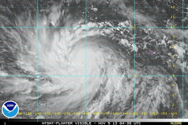
Around 20 storms enter the Philippine Area of Responsiblity every year. The country has also been ranked third most disaster-prone country in the world. In November 2013, it was ravaged by Super Typhoon Yolanda (Haiyan), said to be the strongest to make landfall in recorded history. – With reports from Pia Ranada/Rappler.com
Add a comment
How does this make you feel?


There are no comments yet. Add your comment to start the conversation.