SUMMARY
This is AI generated summarization, which may have errors. For context, always refer to the full article.
What’s the weather like in your area? Tweet us at @rapplerdotcom.
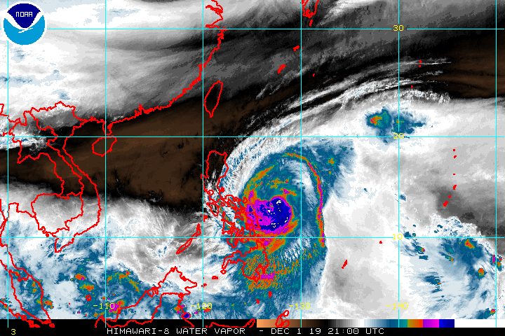
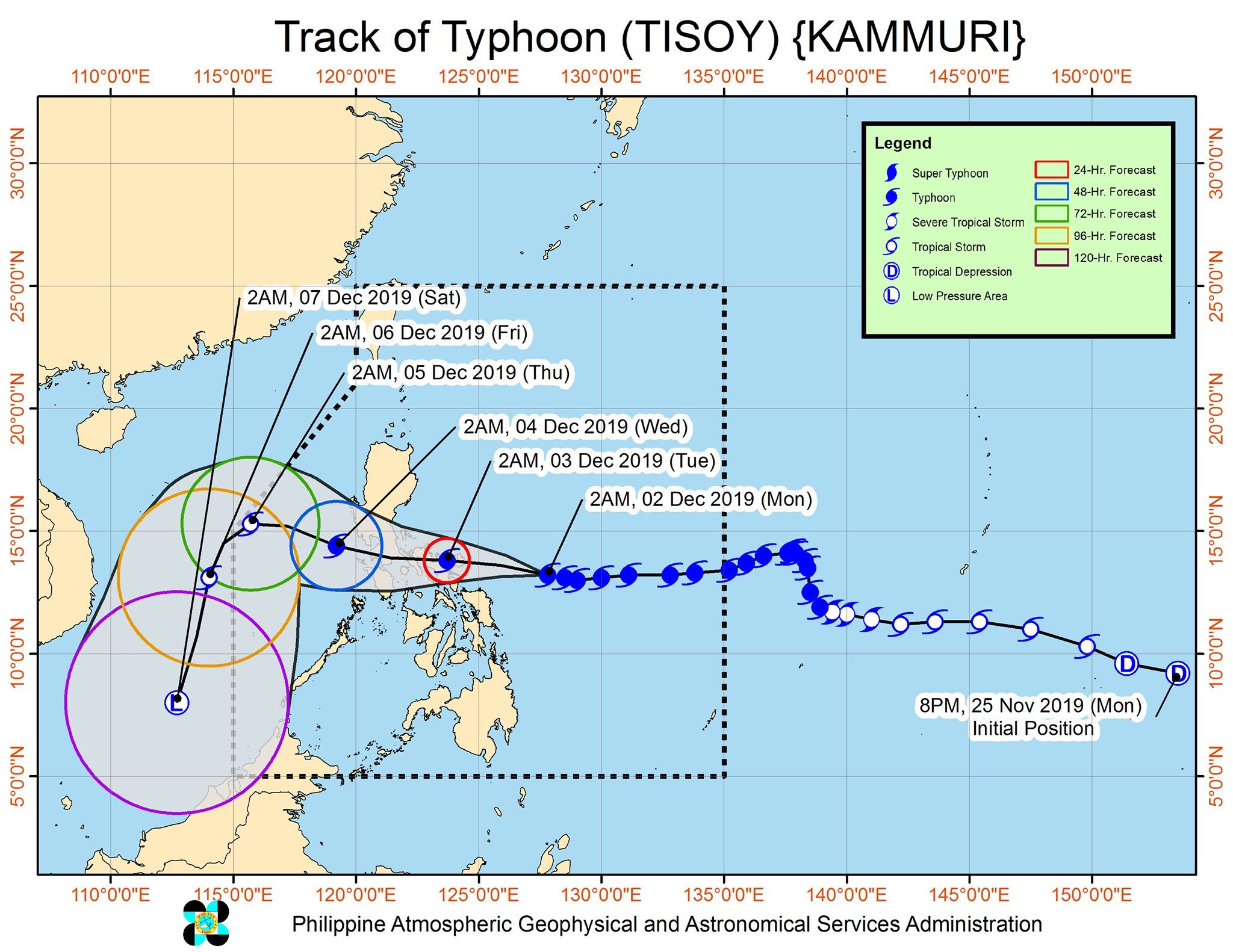
MANILA, Philippines – Signal No. 3 was raised in Catanduanes before dawn on Monday, December 2, as Typhoon Tisoy (Kammuri) slightly intensified.
In a briefing past 5 am on Monday, the Philippine Atmospheric, Geophysical, and Astronomical Services Administration (PAGASA) said Tisoy is already 355 kilometers east of Virac, Catanduanes.
It is still moving west at 20 kilometers per hour (km/h).
The typhoon now has maximum winds of 150 km/h from the previous 140 km/h and gustiness of up to 185 km/h from the previous 170 km/h. (READ: FAST FACTS: Tropical cyclones, rainfall advisories)
Tisoy is expected to make landfall either in Catanduanes or Albay, which are both provinces in Bicol, between Monday evening and early Tuesday morning, December 3.
Aside from Catanduanes, many other areas are under a tropical cyclone wind signal. Here’s the latest list, now totaling 51 places:
Signal No. 3 (winds of 121 km/h to 170 km/h)
- Catanduanes
Signal No. 2 (winds of 61 km/h to 120 km/h)
- eastern part of Laguna (Pakil, Mabitac, Santa Maria, Famy, Siniloan, Pangil, Paete, Kalayaan, Lumban, Santa Cruz, Pagsanjan, Cavinti, Pila, Magdalena, Luisiana, Nagcarlan, Liliw, Majayjay, Rizal, San Pablo City)
- eastern part of Batangas (Padre Garcia, Rosario, Taysan, Lobo, San Juan)
- Quezon including Polillo Island
- Oriental Mindoro
- Marinduque
- Romblon
- Camarines Norte
- Camarines Sur
- Albay
- Sorsogon
- Masbate including Ticao Island and Burias Island
- Northern Samar
- Eastern Samar
- Samar
- Biliran
Signal No. 1 (winds of 30 km/h to 60 km/h)
- southern part of Isabela (Palanan, Dinapigue, San Mariano, San Guillermo, Benito Soliven, Naguilian, Reina Mercedes, Luna, Aurora, Cabatuan, San Mateo, Cauayan City, Alicia, Angadanan, Ramon, San Isidro, Echague, Cordon, Santiago City, Jones, San Agustin)
- Mountain Province
- Ifugao
- Benguet
- Nueva Vizcaya
- Ilocos Sur
- La Union
- Pangasinan
- Quirino
- Aurora
- Nueva Ecija
- Tarlac
- Pampanga
- Bulacan
- Zambales
- Bataan
- Metro Manila
- Rizal
- Cavite
- rest of Laguna
- rest of Batangas
- Occidental Mindoro
- Calamian Islands
- Aklan
- Capiz
- Antique
- Iloilo
- Guimaras
- northern part of Negros Occidental (Bacolod City, Bago City, Cadiz City, Calatrava, Enrique B Magalona, Escalante City, La Carlota City, Manapla, Murcia, Pulupandan, Sagay City, Salvador Benedicto, San Carlos City, San Enrique, Silay City, Talisay City, Toboso, Valladolid, Victorias City)
- northern part of Cebu (Daanbantayan, Bantayan, Madridejos, Santa Fe, Medellin, Bogo City, San Remigio, Tabogon, Tabuelan, Borbon, Sogod, Catmon, Asturias)
- Metro Cebu (Balamban, Toledo City, Pinamungahan, Aloguinsan, Naga City, Talisay City, Cordova, Minglanilla, Lapu-Lapu City, Mandaue City, Cebu City, Consolacion, Liloan, Compostela, Danao City)
- Leyte
- Southern Leyte
- Dinagat Islands
- Siargao Island
PAGASA added that gusty conditions may also be experienced in areas in Northern Luzon that are not under any tropical cyclone wind signal, due to the northeast monsoon or hanging amihan.
Tisoy is also bringing rain which would be intense at its peak. Below is PAGASA’s newest rainfall outlook.
Until Monday afternoon, December 2
- Intermittent to occasional heavy rain
- Bicol
- Eastern Visayas
- northern part of Cebu
- Dinagat Islands
- Siargao Island
Between Monday afternoon, December 2, and Tuesday noontime, December 3
- Frequent to continuous heavy to intense rain
- Bicol
- southern part of Quezon
- Marinduque
- Occasional heavy rain
- Northern Samar
- Romblon
- Occidental Mindoro
- Oriental Mindoro
- rest of Calabarzon
- Intermittent heavy rain
- Metro Manila
- eastern part of Cagayan
- eastern part of Isabela
- rest of Eastern Visayas
Tuesday afternoon, December 3, until Wednesday noontime, December 4
- Frequent to continuous heavy to intense rain
- Central Luzon
- Metro Manila
- Calabarzon
- Bicol
- Occidental Mindoro
- Oriental Mindoro
- Marinduque
- Romblon
- Intermittent to occasional heavy rain
- Cordillera Administrative Region
- Cagayan Valley
- Pangasinan
- Aklan
- Capiz
- northern part of Antique
PAGASA warned that Tisoy could trigger flash floods and landslides.
Ahead of Tisoy’s landfall, thousands of people have fled their homes. Albay, one of the potential landfall areas, ordered mandatory evacuation for those living in high-risk zones prone to lahar, landslides, floods, and storm surges.
Storm surges 1 to 3 meters high might affect several coastal areas in Quezon, Camarines Norte, Camarines Sur, Catanduanes, and Samar.
Travel is also risky, especially for small vessels, in the seaboards of areas under tropical cyclone wind signals, the seaboards of Northern Luzon, the western seaboard of Palawan, the central seaboards of the Visayas, and the northern and eastern seaboards of Mindanao.
Classes were suspended in many areas for Monday. (READ: #WalangPasok: Class suspensions, Monday, December 2, 2019)
Tisoy also looms as the Philippines hosts the 2019 Southeast Asian Games, with the venues of the regional meet in the typhoon’s path.
Based on its latest forecast track, Tisoy is expected to leave the Philippine Area of Responsibility on Thursday morning, December 5.
Tisoy is the Philippines’ 20th tropical cyclone for 2019. (READ: LIST: PAGASA’s names for tropical cyclones in 2019)
The country gets an average of 20 tropical cyclones annually. In the earlier part of the year, only 14 to 18 tropical cyclones had been projected since 2019 is an El Niño year.
For the month of December, PAGASA had been expecting 0 to 1 tropical cyclone.
PAGASA declared the start of the rainy season last June 14. – Rappler.com
Add a comment
How does this make you feel?
There are no comments yet. Add your comment to start the conversation.