SUMMARY
This is AI generated summarization, which may have errors. For context, always refer to the full article.
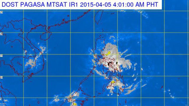
MANILA, Philippines (4th UPDATE) – The center of Chedeng (Maysak), which has weakened into a tropical depression, made landfall at 8am Sunday morning, April 5, in Dinapigue, Isabela, PAGASA chief weather forecaster Esperanza Cayanan said in a media briefing.
The state weather bureau said the first half of Chedeng is dry but “moderate to at times heavy rainfall” may follow because satellite images still show thin cloud bands in the other half.
Cayanan said Chedeng, whose winds slowed down to 55 kilometers per hour, is expected to further weaken into a low pressure area (LPA) within 24 hours especially after hitting the mountains of the Sierra Madre.
State weather forecaster Shelly Ignacio said the super typhoon met unfavorable atmospheric conditions as it approached land, causing the storm system to dissipate dramatically overnight Saturday.
At its current strength, Maysak can break tree branches and may take the roofs off houses made of light materials, while sea travel remains risky for small boats, the state weather service said in its latest bulletin.
“We expect this system to melt away as it crosses the mountains, although there is a small possibility it could survive by the time it hits the water (South China Sea) tomorrow,” she added.
In its 11 am bulletin, the state weather bureau said the center of tropical depression Chedeng is now over Palanan, Isabela.
It is forecast to move northwest at 13 km/h.
By Monday morning, April 6, it is expected to be 125 km north-northwest of Laoag City.
Land travel is now allowed in affected areas including Aurora province. Motorists, however, are told to take precautions because of possible rains, especially in the eastern side of Luzon, around lunchtime to early afternoon.
The government had evacuated more than 25,000 people from coastal villages in the region, while police drove away thousands of tourists from beaches on nearby Aurora province as a precaution against potential tsunami-like waves known as storm surges.
The tourists, many of whom had come from Manila and nearby areas to enjoy the long Easter holidays in the mainly Catholic nation, breathed a sigh of relief and dived back into the still choppy waters on Easter Sunday.
“We made a calculated risk (that Maysak would dissipate) and we got lucky. Prayers also helped,” Manila-based television producer Rona Agtay, 39, told Agence France-Presse as she hit the surf.
No casualties
NDRRMC chief Alexander Pama said it is up to the LGUs to declare if it’s safe to go back to the beaches, noting that some areas are still reporting high waves.
Fishermen using small bancas are still not allowed to sail.
Pama said the NDRRMC is still on red alert. No casualties have been reported since Saturday night, April 4.
Faustino Dy, governor of Isabela province, which includes Dinapigue, told Manila radio station DZBB that people were returning to their coastal homes after Maysak passed over the area uneventfully.
About three dozen surfers rode shoulder-high waves at the Sabang resort in the Aurora provincial capital of Baler, while others lounged on the beach in overcast conditions with a brisk wind, but no rain, an AFP photographer said.
“Yesterday the police came and stopped us from going into the water,” said TV producer Agtay, who took a bus bound for Baler as Maysak churned towards the area.
“Some of police officers even went out there on board surfboards because a few people refused to leave the water.”
Only 4 areas in Luzon remain under Public Storm Signal No. 1 (winds of 30-60 km/h expected in at least 36 hours) as of PAGASA’s 11 am bulletin:
- Kalinga
- Isabela
- Ifugao
- Mountain Province
Effects of the wind under Signal No. 1:
- Breaking twigs and branches of trees
- Damage to rice crops in the flowering stage
- Possible partial unroofing or some nipa and cogon houses
These areas will have occasional rains with occasional gusty winds.
About 20 typhoons and storms hit the Philippines each year, many of them deadly, but rarely hit in April.
Storm surges caused many of the fatalities when Super Typhoon Haiyan smashed onto the central Philippines in November 2013, leaving more than 7,350 people dead or missing. – with reports from Agence France-Presse/Rappler.com
Add a comment
How does this make you feel?


There are no comments yet. Add your comment to start the conversation.