SUMMARY
This is AI generated summarization, which may have errors. For context, always refer to the full article.
MANILA, Philippines (UPDATED) – Typhoon Lando (international codename Koppu) continues to gain strength as it moves towards the Aurora-Isabela area, said state weather bureau PAGASA on Friday late morning, October 16.
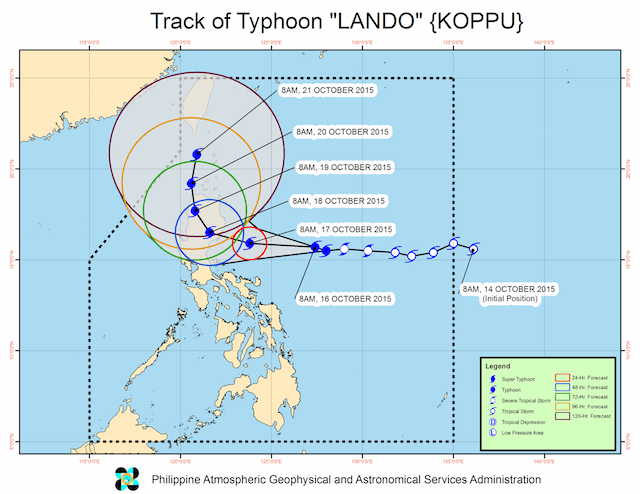
As of 10 am Friday, the center of Typhoon Lando was located at 585 km east of Baler, Aurora, with maximum sustained winds of 130 km/h near the center and gustiness of up to 160 km/h.
The Japan Meteorological Agency classified Lando as a typhoon with a strong intensity.
It is still moving west in direction at 15 km/h, with heavy to intense rainfall estimated within its 550-km diameter.
Typhoon Lando is expected to make landfall in the Aurora-Isabela area between 4 am to 8 am Sunday, October 18.
PAGASA has now raised Public Storm Warning No. 2 (61-120 km/h expected in 24 hours) over Aurora and Isabela. Storm surge is possible at coastal areas under this storm signal, as open sea wave height can go from 4.1 m to 14.0 m.
Meanwhile, Signal No. 1 has been raised over more areas (30-60 km/h expected in 36 hours):
- Cagayan
- Kalinga
- Mt. Province
- Ifugao
- Benguet
- Quirino
- Nueva Viscaya
- Nueva Ecija
- Bulacan
- Pampanga
- Tarlac
- Pangasinan
- Rizal
- Quezon, including Polillo Island
- Camarines Norte
- Camarines Sur
- Catanduanes
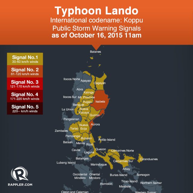
PAGASA said there is a possibility to raise Signal No. 1 over La Union, Abra, Ilocos Sur, Ilocos Norte, Zambales, Metro Manila.
PAGASA has warned fisherfolk against venturing out over the northern and western seaboards of Northern Luzon, the western seaboard of Central Luzon, and the eastern seaboard of Visayas.
The next bulletin on Typhoon Lando will be issued at 5 pm Friday. – Rappler.com
Add a comment
How does this make you feel?
There are no comments yet. Add your comment to start the conversation.