SUMMARY
This is AI generated summarization, which may have errors. For context, always refer to the full article.

MANILA, Philippines (UPDATED) – Typhoon “Bopha” is expected to enter the Philippine Area of Responsibility (PAR) Sunday evening, December 2, and will be named Pablo, the state weather bureau PAGASA said.
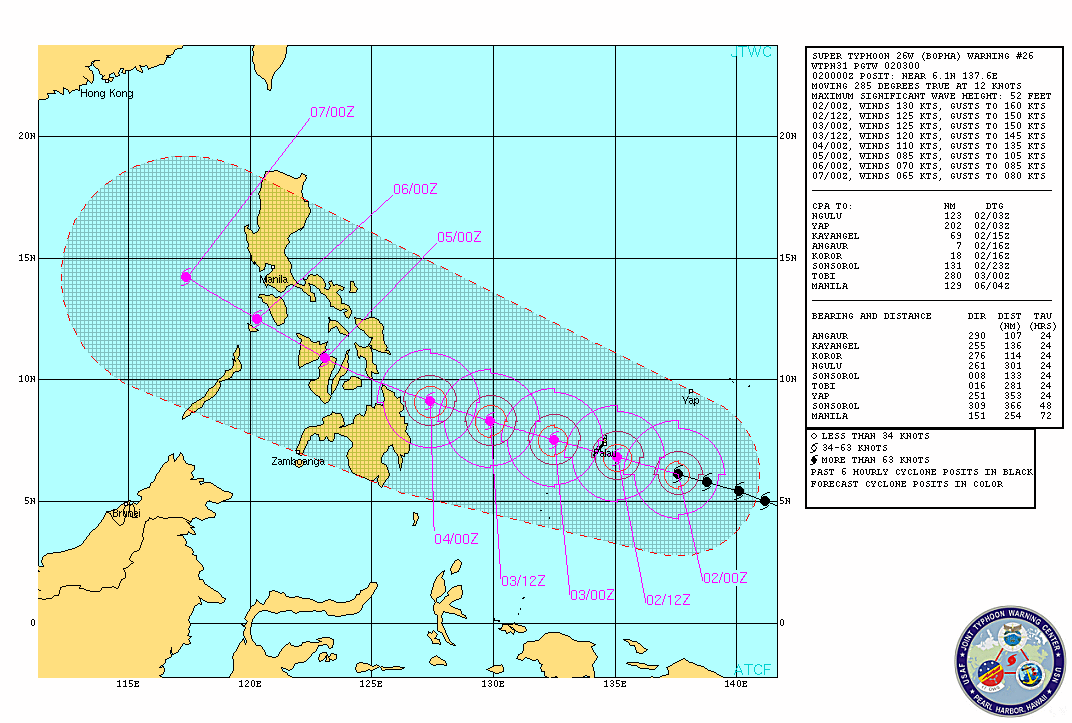
As of 10 am Sunday, Bopha was located 1,110 kilometers east southeast Hinatuan, Surigao del Sur (6.3°N, 137.1°E), carrying maximum sustained winds of 185 km/h and gusts of up to 220 km/h.
It is currently forecast to move northwest at 22 km/h.
By Monday morning, December 3, the typhoon is expected to be 660 km east of Hinatuan, and will move closer to the town (140 km) by Tuesday morning.
It is expected to hit land by Tuesday, in the vicinity of Surigao del Norte.
Heavy to intense rainfall (20-30 mm/h) is expected within the typhoon’s 700 km diameter, and large parts of Mindanao and Visayas should prepare for floods and landslides.
The island-nation of Palau, which is within the PAR, will be the first landmass that will be hit by the typhoon, PAGASA said.
Within the Philippines, on the other hand, there are no public storm warning signals raised yet, since the typhoon is still too far to affect any part of the country.
Forecast tracks provided by the Japan Meteorological Agency, US Navy’s Joint Typhoon Warning Center, and the Taiwan Central Weather Bureau show that the typhoon is expected to cross the central area of the Philippines, particularly northern Mindanao and the Visayas.
The JTWC is already labeling the typhoon a supertyphoon, while the JMA said the typhoon is expected to be “very strong.”
Usec. Benito Ramos, executive director of the National Disaster Risk Reduction and Management Council (NDRRMC), appealed to citizens, especially those along the path of the typhoon, to heed warnings as early as now.
“Do not wait for your LGUs [to warn you],” Ramos said during a press conference at the PAGASA headquarters in Quezon City.
He also implored fishermen in the affected areas to avoid going out to sea in the next few days to avoid the strong waves and winds brought by the typhoon.
PAGASA Tropical Cyclone Warning for Shipping, Typhoon Bopha, 2 Dec 2012 11am
Stronger than ‘Sendong’
Weather bureau Philippine Atmospheric Geophysical and Astronomical Services Administration (PAGASA) said Bopha can become a super typhoon, way stronger than Tropical Storm “Sendong” (international name: Washi) in terms of rainfall and wind strength.
Sendong wrought destruction on the country in December 2011, killing over 1,470, hurting over 2,000, and affecting over a million Filipinos.
As early as now, local government units are preparing for the potential super typhoon.
“Enough time for the government to prepare, national and local,” Ramos told Rappler in an earlier interview.
Sunday weather
With Bopha still outside the PAR, partly cloudy skies will prevail over Bicol, Eastern Visayas, Mindanao, and Aurora and Quezon provinces, PAGASA said.
The said areas will also experience isolated brief rain or thunderstorms, state weather bureau PAGASA said.
The rest of the archipelago will have fair weather.
Prevailing winds will mainly come from the northeast to east.
PAGASA 24-Hour Public Weather Forecast, 2 December 2012, 5am
– Rappler.com
Add a comment
How does this make you feel?
There are no comments yet. Add your comment to start the conversation.