SUMMARY
This is AI generated summarization, which may have errors. For context, always refer to the full article.
What’s the weather like in your area? Report the situation through Rappler’s Agos or tweet us at @rapplerdotcom.
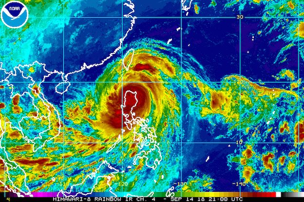
MANILA, Philippines – Fierce winds and heavy rain battered Luzon before dawn on Saturday, September 15, after Typhoon Ompong (Mangkhut) made landfall in Baggao, Cagayan at 1:40 am.
In a bulletin issued 5 am on Saturday, the Philippine Atmospheric, Geophysical, and Astronomical Services Administration (PAGASA) said Ompong is already in the vicinity of Baggao, still moving west northwest at 35 kilometers per hour (km/h). It’s heading for the provinces of Apayao and Ilocos Norte.
Ompong’s maximum winds are slightly down from 205 km/h to 200 km/h, but the gustiness has increased from 285 km/h to 330 km/h. Though it is not a super typhoon under PAGASA’s classification system, it remains a powerful tropical cyclone with a huge diameter of 900 kilometers.
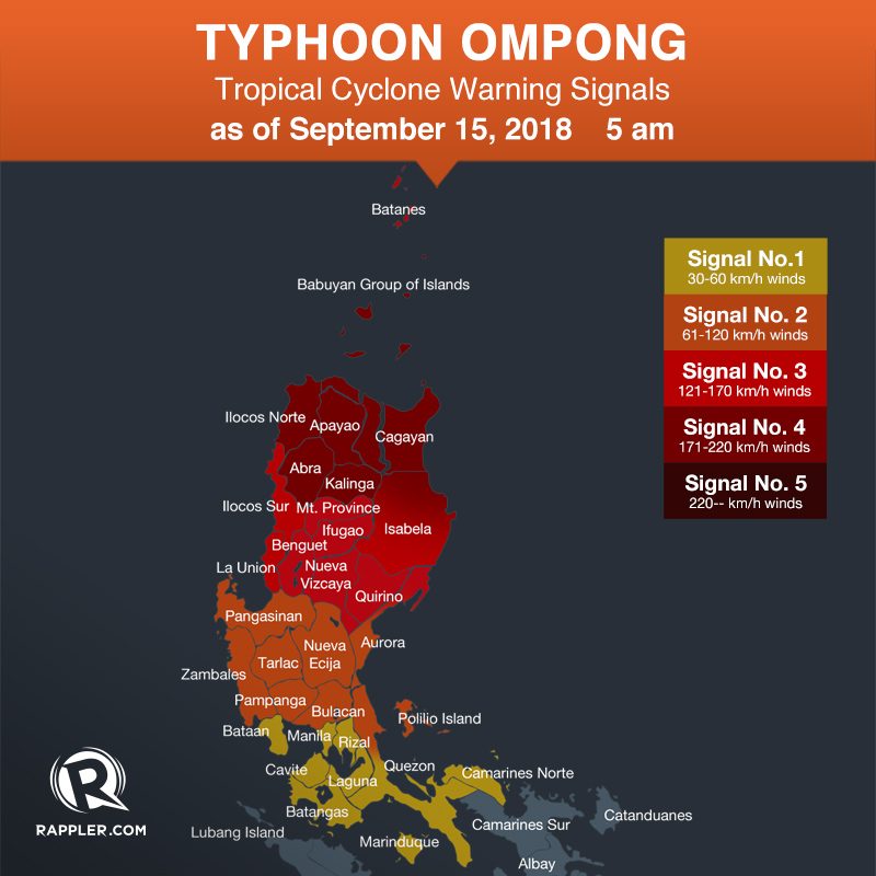
Below are the tropical cyclone warning signals in place.
Signal No. 4:
- Cagayan including Babuyan Group of Islands
- northern part of Isabela
- Apayao
- Abra
- Ilocos Norte
- Kalinga
Signal No. 3:
- Batanes
- southern part of Isabela
- Ilocos Sur
- La Union
- Mountain Province
- Benguet
- Ifugao
- Nueva Vizcaya
- Quirino
- northern part of Aurora
Signal No. 2:
- Pangasinan
- Tarlac
- Nueva Ecija
- southern part of Aurora
- Zambales
- Pampanga
- Bulacan
- northern part of Quezon including Polillo Island
Signal No. 1:
- Bataan
- Rizal
- Metro Manila
- Cavite
- Batangas
- Laguna
- southern part of Quezon
- Lubang Island
- Marinduque
- Camarines Norte
The National Disaster Risk Reduction and Management Council earlier estimated that at least 5.2 million people are in the path of the typhoon.
Thousands of people in affected areas had evacuated ahead of Ompong’s landfall. (READ: Will Typhoon Ompong be the same as Super Typhoon Lawin?)
PAGASA warned that serious floods and landslides are possible, while many trees could get uprooted and homes made of light materials may be damaged. Some power lines have already been affected, while at least 3 dams were forced to release water.
Coastal areas in Cagayan and Ilocos Norte could also experience storm surges up to 6 meters high, Isabela up to 3 meters, and Ilocos Sur, La Union, and Pangasinan up to 2 meters. (READ: FAST FACTS: Tropical cyclones, rainfall advisories)
Fishermen and others with small sea vessels are advised not to venture out into the seaboards of areas under tropical cyclone warning signals, the seaboards of Luzon and the Visayas, and the northern and western seaboards of Mindanao.
More than 4,800 passengers have been stranded in various ports. Domestic and international flights have been canceled. (READ: DFA giving P5,000 aid for OFWs stranded due to Typhoon Ompong)
Classes were also suspended in various regions. (READ: #WalangPasok: Class suspensions for September 13, 14, 15)
Aside from directly affecting Luzon, Ompong is enhancing the southwest monsoon or hanging habagat. The enhanced southwest monsoon will trigger gusty winds and moderate to heavy rain in Western Visayas, the Zamboanga Peninsula, the Autonomous Region in Muslim Mindanao, and the rest of Mimaropa and Bicol. Scattered light to heavy rains will also hit Eastern Visayas and Central Visayas.
Residents of areas affected by the southwest monsoon should be on alert for flash floods and landslides, too.
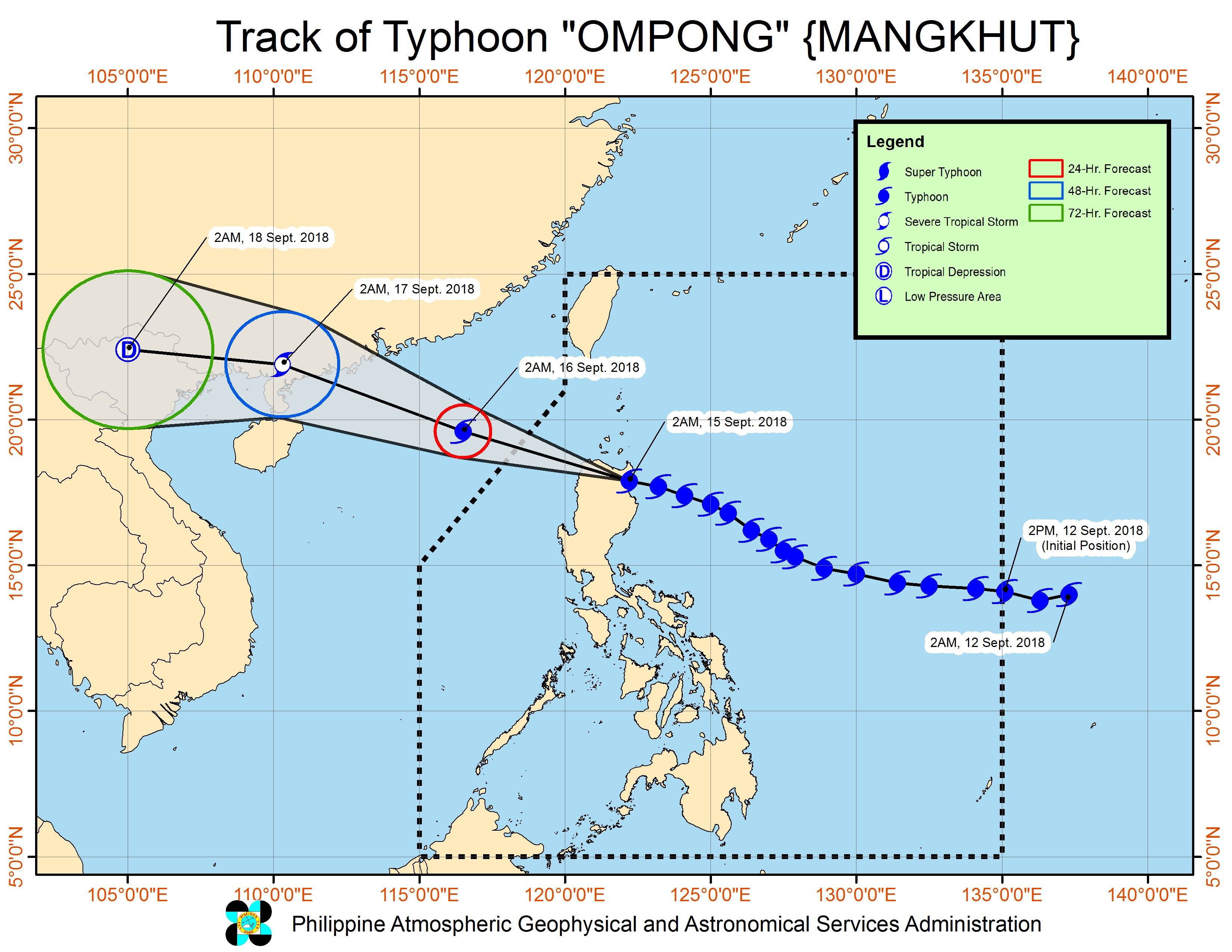
Based on its latest forecast track, Ompong might leave the Philippine Area of Responsibility (PAR) on Saturday evening. This estimated time of exit could still change if it slows down.
PAGASA cautioned, however, that even if the eye of the typhoon would already be outside PAR, it could still affect parts of Luzon due to its wide diameter. (READ: COMPARISON: Typhoon Ompong and previous Philippine typhoons)
National government agencies, local government units, the Armed Forces of the Philippines, the Philippine National Police, and the Philippine Coast Guard were placed on alert to respond to the typhoon. (READ: What gov’t has done so far to prepare for Typhoon Ompong)
Ompong is the Philippines’ 15th tropical cyclone for 2018. The country usually gets an average of 20 tropical cyclones per year. (READ: LIST: PAGASA’s names for tropical cyclones in 2018)
PAGASA declared the start of the rainy season last June 8. – Rappler.com
News you can use during Typhoon Ompong (Mangkhut):
- Weather updates and storm signals
- Reports on evacuation, emergencies, and rescue and relief efforts
- Typhoon Ompong: Free parking at SM, Ayala, Robinsons, Megaworld malls
- #WalangPasok: Class suspensions for September 13, 14, 15
- Canceled flights due to Typhoon Ompong
- Will Typhoon Ompong be the same as Super Typhoon Lawin?
- COMPARISON: Typhoon Ompong and previous Philippine typhoons
- What gov’t has done so far to prepare for Typhoon Ompong
- Fact-check on viral stories related to Typhoon Ompong
- DFA giving P5,000 aid for OFWs stranded due to Typhoon Ompong
- 3 dams release water due to Typhoon Ompong
- Power lines affected by Typhoon Ompong
- Roads closed due to Typhoon Ompong
Add a comment
How does this make you feel?
There are no comments yet. Add your comment to start the conversation.