SUMMARY
This is AI generated summarization, which may have errors. For context, always refer to the full article.
What’s the weather like in your area? Tweet us at @rapplerdotcom.
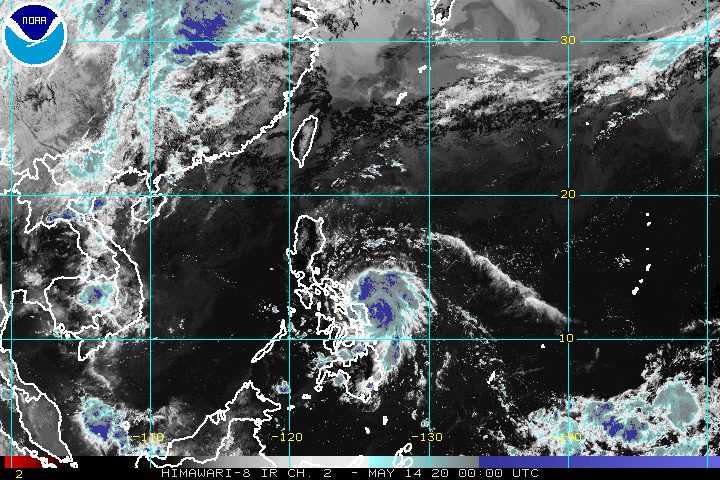
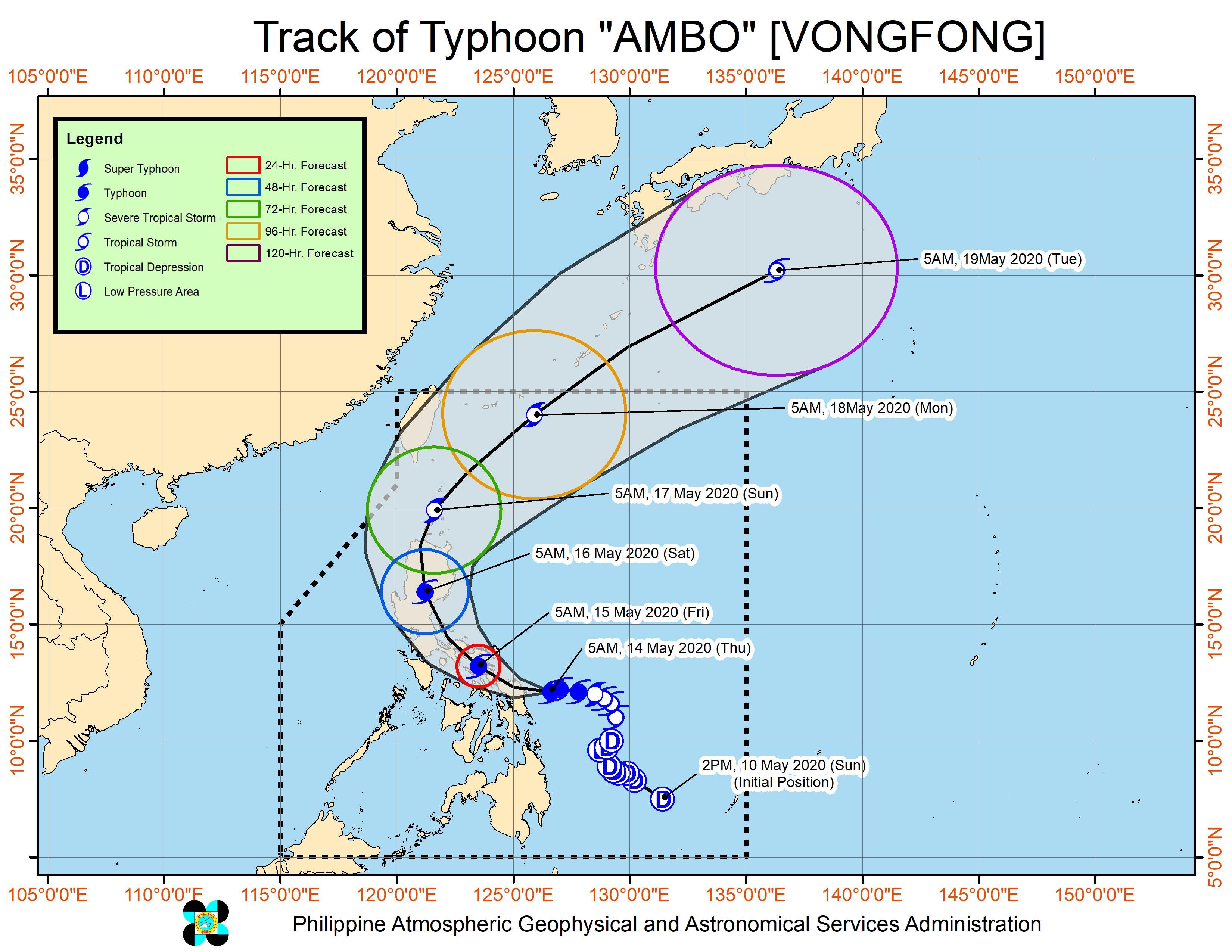
MANILA, Philippines – Typhoon Ambo (Vongfong) strengthened even more early Thursday morning, May 14, and is now threatening the Eastern Samar-Northern Samar area.
In a bulletin issued 8 am on Thursday, the Philippine Atmospheric, Geophysical, and Astronomical Services Administration (PAGASA) said Ambo now has maximum winds of 155 kilometers per hour (km/h) from the previous 150 km/h and gustiness of up to 190 km/h from the previous 185 km/h.
The typhoon remains likely to intensify further before it makes landfall in Northern Samar or in the northern part of Eastern Samar on Thursday afternoon or early evening. (READ: FAST FACTS: Tropical cyclones, rainfall advisories)
The typhoon is already 185 kilometers east southeast of Catarman, Northern Samar, or 110 kilometers east northeast of Borongan City, Eastern Samar, still moving west at 15 km/h.
More areas were placed under tropical cyclone wind signals, including Metro Manila, which is now under Signal No. 1. Below is the complete list. (READ: Why is it now called tropical cyclone ‘wind’ – and not ‘warning’ – signals?)
Signal No. 3 (winds of 121 to 170 km/h, or strong to destructive typhoon-force winds during the passage of the typhoon)
- Sorsogon
- eastern part of Albay (Legazpi City, Manito, Daraga, Camalig, Jovellar, Santo Domingo, Bacacay, Rapu-Rapu)
- Northern Samar
- northern part of Eastern Samar (Jipapad, Arteche, Maslog, Dolores, Oras, San Policarpio, Can-avid, Taft, Sulat, San Julian, Borongan City)
- northern part of Samar (Calbayog City, Sta Margarita, Gandara, Pagsanghan, San Jorge, Matuguinao, San Jose de Buan)
Signal No. 2 (winds of 61 to 120 km/h, or strong to damaging gale-/storm-force winds during the passage of the typhoon)
- southeastern part of Quezon (Tagkawayan, Guinayangan, Buenavista, San Narciso, Mulanay, San Andres, San Francisco)
- Camarines Norte
- Camarines Sur
- Catanduanes
- rest of Albay
- Burias Island
- northern part of mainland Masbate (Aroroy, Baleno, Masbate City, Mobo, Uson, Dimasalang, Palanas, Cataingan, Pio V. Corpuz)
- Biliran
- rest of Samar
- rest of Eastern Samar
Signal No. 1 (winds of 30 to 60 km/h, or strong to near-gale-force winds during the passage of the typhoon)
- southern part of Aurora (Baler, San Luis, Dingalan)
- southern part of Nueva Ecija (Bongabon, Gabaldon, General Tinio, Laur, San Leonardo, Peñaranda, Gapan City)
- Bulacan
- Metro Manila
- Cavite
- Laguna
- Batangas
- Rizal
- rest of Quezon
- Marinduque
- eastern part of Romblon (Banton, Corcuera, Calatrava, San Agustin, Romblon, Magdiwang, San Fernando, Cajidiocan)
- northern part of Leyte (Calubian, San Isidro, Tabango, Villaba, Leyte, Kananga, Capoocan, Carigara, Barugo, San Miguel, Babatngon, Tunga, Jaro, Alangalang, Sta Fe, Tacloban City, Palo, Pastrana, Dagami, Tabontabon, Tanauan, Tolosa, Ormoc City, Matag-ob, Palompon, Merida, Isabel, Albuera, Burauen, Julita, Dulag)
“Violent winds and heavy to torrential rain of the eyewall region will begin affecting Northern Samar and the northern portions of Samar and Eastern Samar in the next 12 hours,” PAGASA warned.
Here is the latest rainfall outlook for affected areas:
Thursday, May 14
Heavy to intense rain, with at times torrential rain
- Northern Samar
- Eastern Samar
- Samar
Moderate to heavy rain, with at times intense rain
- Sorsogon
- Albay
- Catanduanes
- Masbate
- rest of Eastern Visayas
Friday, May 15
Heavy to intense rain, with at times torrential rain
- Bicol
Moderate to heavy rain, with at times intense rain
- Northern Samar
- Quezon
- Aurora
- Marinduque
- Romblon
Floods, landslides, and even lahar from Mayon Volcano are possible. The Philippine Institute of Volcanology and Seismology issued an advisory on Wednesday, May 13, warning that rainfall from Ambo might mix with volcanic deposits from Mayon’s 2018 eruption, which could result in lahar or volcanic mudflows.
PAGASA also warned that in the next 48 hours, there may be storm surges 1 to 3 meters high in these areas:
- Northern Samar
- Eastern Samar (east coast)
- Samar (west coast)
- Sorsogon
- Albay
- Catanduanes
- Camarines Sur
- Camarines Norte
- Quezon
- Aurora
“Along with large swells, this storm surge may cause potentially life-threatening coastal inundation,” PAGASA said.
Sea travel is risky for all vessels in the seaboards of areas under tropical cyclone wind signals.
Ambo is the Philippines’ first tropical cyclone for 2020. The country gets an average of 20 tropical cyclones per year. (READ: LIST: PAGASA’s names for tropical cyclones in 2020)
In PAGASA’s climate outlook, it gave the following estimates for the number of tropical cyclones in the next 6 months:
- May – 1 or 2
- June – 1 or 2
- July – 2 to 4
- August – 2 or 3
- September – 2 or 3
- October – 2 or 3
While bracing for Ambo, the Philippines is also combating the coronavirus outbreak. The number of COVID-19 cases in the country climbed to 11,618 on Wednesday. – Rappler.com
Add a comment
How does this make you feel?
There are no comments yet. Add your comment to start the conversation.