SUMMARY
This is AI generated summarization, which may have errors. For context, always refer to the full article.
What’s the weather like in your area? Tweet us at @rapplerdotcom.
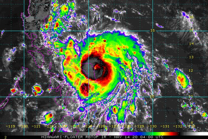
MANILA, Philippines (UPDATED) – Typhoon Ambo (Vongfong) made landfall in San Policarpo, Eastern Samar, at 12:15 pm on Thursday, May 14, the first to hit the country in 2020 and in the midst of the coronavirus outbreak.
In a bulletin released past 2 pm on Thursday, the Philippine Atmospheric, Geophysical, and Astronomical Services Administration (PAGASA) said Ambo is already in the vicinity of Oras, Eastern Samar.
It is still moving west at 15 kilometers per hour (km/h), now heading for the northern part of Samar.
The typhoon continues to have maximum winds of 155 km/h and gustiness of up to 190 km/h. (READ: FAST FACTS: Tropical cyclones, rainfall advisories)
As Ambo hit land, its eyewall started bringing violent winds and heavy to intense rain to the northern part of Eastern Samar, said PAGASA.
The northern part of Samar and the southern part of Northern Samar will be affected by the eyewall in the coming hours as well.
Signal Nos. 1, 2, and 3 remain in effect in parts of the Visayas and of Luzon. Below is the latest list. (READ: Why is it now called tropical cyclone ‘wind’ – and not ‘warning’ – signals?)
Signal No. 3 (winds of 121 to 170 km/h, or strong to destructive typhoon-force winds during the passage of the typhoon)
- Sorsogon
- Albay
- Masbate including Ticao Island and Burias Island
- Catanduanes
- southern part of Camarines Sur (Cabusao, Libmanan, Pasacao, Pamplona, Canaman, Magarao, Bombon, Calabanga, Camaligan, Gainza, San Fernando, Milaor, Naga, Tinambac, Siruma, Pili, Goa, Lagonoy, Garchitorena, Minalabac, Caramoan, Presentacion, Bula, Ocampo, Tigaon, San Jose, Balatan, Nabua, Baao, Sagñay, Bato, Nabua, Iriga, Buhi)
- Northern Samar
- northern part of Eastern Samar (Jipapad, Arteche, Maslog, Dolores, Oras, San Policarpio, Can-avid, Taft, Sulat, San Julian, Borongan City, Maydolong)
- northern part of Samar (Calbayog City, Sta Margarita, Gandara, Pagsanghan, San Jorge, Matuguinao, San Jose de Buan, Catbalogan City, Jiabong, Motiong, Paranas, Tarangnan, San Sebastian, Hinabangan)
- Biliran
Signal No. 2 (winds of 61 to 120 km/h, or strong to damaging gale-/storm-force winds during the passage of the typhoon)
- Camarines Norte
- rest of Camarines Sur
- southern part of Quezon (Mauban, Sampaloc, Lucban, Sariaya, Tayabas City, Lucena, Pagbilao, Atimonan, Padre Burgos, Plaridel, Agdangan, Unisan, Gumaca, Pitogo, Macalelon, Lopez, Caluag, General Luna, Catanauan, Perez, Alabat, Quezon, Tagkawayan, Guinayangan, Buenavista, San Narciso, Mulanay, San Andres, San Francisco)
- Marinduque
- northernmost part of Leyte (Calubian, San Isidro, Tabango, Leyte, Capoocan, Carigara, Barugo, San Miguel, Babatngon, Tunga, Alangalang, Sta Fe, Palo, Tacloban City, Jaro)
- rest of Samar
- rest of Eastern Samar
Signal No. 1 (winds of 30 to 60 km/h, or strong to near-gale-force winds during the passage of the typhoon)
- Aurora
- southern part of Nueva Ecija (General Mamerto Natividad, Palayan City, Cabanatuan, Santa Rosa, Jaen, San Isidro, San Antonio, Cabiao, Bongabon, Gabaldon, General Tinio, Laur, San Leonardo, Peñaranda, Gapan City)
- Bulacan
- Metro Manila
- Cavite
- Laguna
- Batangas
- Rizal
- rest of Quezon
- Romblon
- Bataan
- Pampanga
- rest of northern part of Leyte (Villaba, Kananga, Matag-ob, Palompon, Ormoc, Merida, Isabel, Ormoc City, Albuera, Pastrana, Dagami, Tanauan, Tabontabon, Tolosa, Burauen, Julita, Dulag)
- northeastern part of Capiz (Pilar)
- northeastern part of Iloilo (Carles, Balasan, Estancia, Batad)
- northern part of Cebu (Medellin, Daanbantayan, Madridejos, Bantayan, Santa Fe)
PAGASA gave the following rainfall outlook:
Thursday, May 14
Heavy to intense rain
- Northern Samar
- Eastern Samar
- Samar
- Masbate
- Sorsogon
- Catanduanes
Moderate to heavy rain, with at times intense rain
- Albay
- Camarines Sur
- rest of Eastern Visayas
Friday, May 15
Heavy to intense rain
- Bicol
Moderate to heavy rain, with at times intense rain
- Northern Samar
- Quezon
- Aurora
- Marinduque
- Romblon
Floods, landslides, and even lahar from Mayon Volcano are possible. The Philippine Institute of Volcanology and Seismology issued an advisory on Wednesday, May 13, warning that rainfall from Ambo might mix with volcanic deposits from Mayon’s 2018 eruption, which could result in lahar or volcanic mudflows.
The typhoon may also cause storm surges 2 to 4 meters high within 24 hours. These areas should be on alert for “potentially life-threatening coastal inundation”:
- Northern Samar
- Eastern Samar (east coast)
- Samar (west coast)
- Sorsogon
- Albay
- Catanduanes
- Camarines Sur
- Camarines Norte
- Quezon
- Aurora
Sea travel is risky for all vessels in the seaboards of areas under tropical cyclone wind signals.
The Department of Agriculture, meanwhile, said in a virtual briefing on Thursday that 175,954 hectares of rice and 89,303 hectares of corn are at risk due to Ambo.
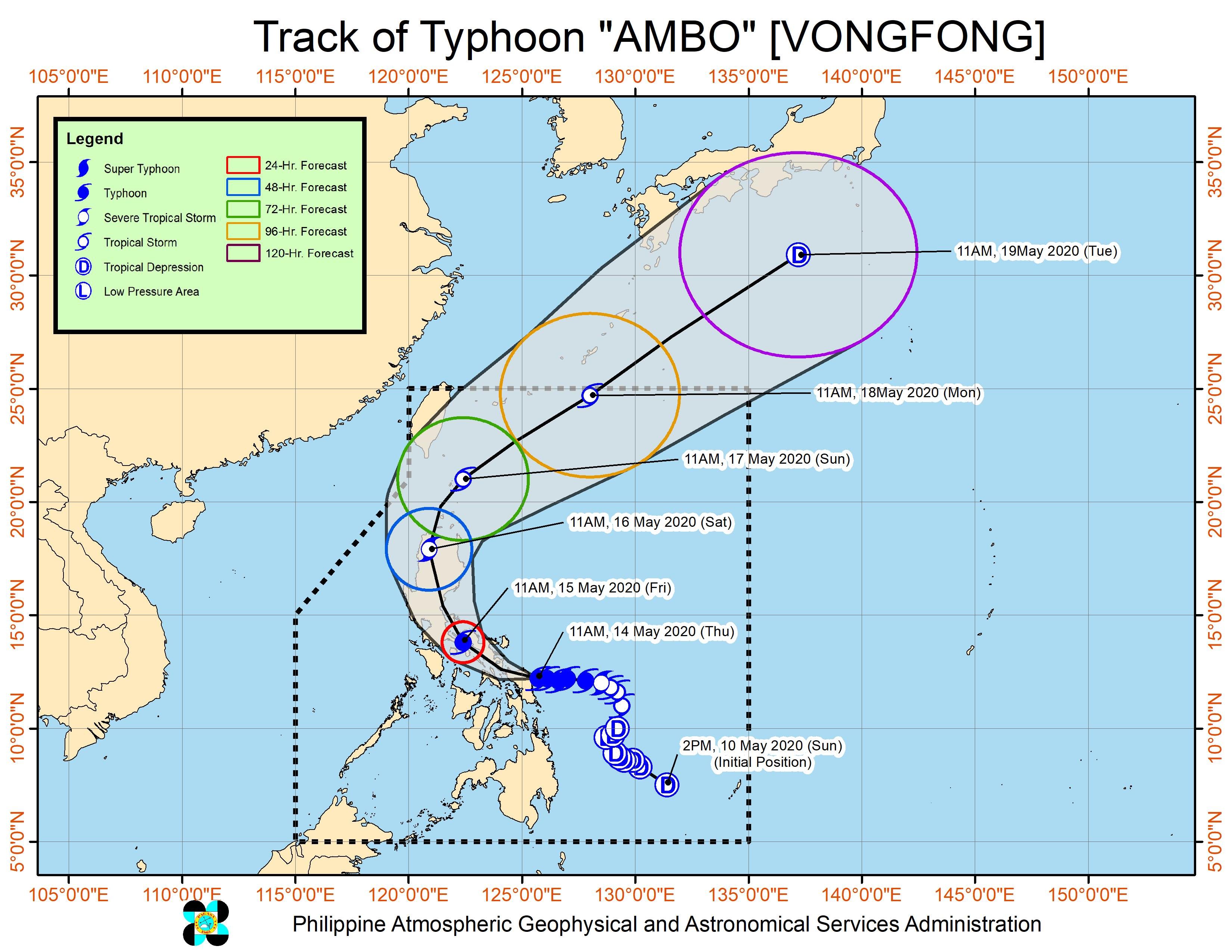
Ambo is the Philippines’ first tropical cyclone for 2020. The country gets an average of 20 tropical cyclones per year. (READ: LIST: PAGASA’s names for tropical cyclones in 2020)
In PAGASA’s climate outlook, it gave the following estimates for the number of tropical cyclones in the next 6 months:
- May – 1 or 2
- June – 1 or 2
- July – 2 to 4
- August – 2 or 3
- September – 2 or 3
- October – 2 or 3
– Rappler.com
Add a comment
How does this make you feel?
There are no comments yet. Add your comment to start the conversation.