SUMMARY
This is AI generated summarization, which may have errors. For context, always refer to the full article.
What’s the weather like in your area? Tweet us the situation: Use #weatheralert and tag @rapplerdotcom.
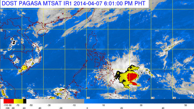
MANILA, Philippines – Tropical Storm Domeng (international name Peipah) has weakened into a tropical depression but may still cause storm surges in Visayas.
According to state weather bureau PAGASA’s 5 pm, April 7 update, Domeng’s maximum sustained speeds went down to 55 kilometers per hour (kph) from its earlier speed of 65 kph. It was spotted at 4 pm 670 km east of Davao City.
It is forecasted to move west northwest at 13 kph. Earlier PAGASA data predicted it would make landfall on Wednesday, April 9 when it would be 30 km from Surigao City.
Independent weather group Weather Philippines said Domeng could make landfall on Thursday afternoon over the border between Surigao del Norte and Surigao del Sur.
(Data from Weather Philippines is not official data. Official weather information is issued by state weather bureau PAGASA.)
Storm surge warnings
Though Domeng has weakened, it may still cause storm surges a little less than 1 meter (3.3 feet) in provinces in the Visayas and Mindanao, according to data from Project NOAH. (INFOGRAPHIC: Storm surge 101: Are you at risk? Are you prepared for it?)
The provinces are Leyte, Cebu, Iloilo, Negros Oriental and Biliran in the Visayas and Maguindanao, Surigao del Norte and Surigao del Sur in Mindanao.
Rains in Visayas, Mindanao, Cagayan Valley
Because of Tropical Depression Domeng, Mindanao, Eastern and Central Visayas and parts of Cagayan Valley will have cloudy skies bringing scattered rainshowers and thunderstorms.
Help map reports about Domeng through Rappler’s civic engagement for disaster risk reduction platform Project Agos.
Metro Manila and the rest of the country will have fairer weather: partly cloudy skies with isolated rainshowers or thunderstorms in the afternoon or evening.
The northern and eastern part of the country should prepare for moderate to strong winds coming from the northeast. Thus, coastal waters in these areas will be moderate to rough.
Elsewhere, winds will be light to moderate coming from the northeast to east leading to slight to moderate seas.
| City | Forecast | Temperature Range |
|
| Metro Manila |  |
Partly cloudy to cloudy skies with isolated rainshowers or thunderstorms |
22°C-34°C |
| Tuguegarao |  |
Cloudy with rainshowers or thunderstorms | 23°C-32°C |
| Laoag | |
Partly cloudy to cloudy skies with isolated rainshowers or thunderstorms |
24°C-33°C |
| Baguio | |
Partly cloudy to cloudy skies with isolated rainshowers or thunderstorms |
15°C-24°C |
| Subic/Olongapo; Clark/Angeles | |
Partly cloudy to cloudy skies with isolated rainshowers or thunderstorms |
25°C-33°C |
| Tagaytay | |
Partly cloudy to cloudy skies with isolated rainshowers or thunderstorms |
22°C-31°C |
| Lipa | |
Partly cloudy to cloudy skies with isolated rainshowers or thunderstorms |
22°C-32°C |
| Legazpi | |
Partly cloudy to cloudy skies with isolated rainshowers or thunderstorms |
25°C-31°C |
| Puerto Princesa | |
Partly cloudy to cloudy skies with isolated rainshowers or thunderstorms |
24°C-33°C |
| Iloilo/Bacolod | |
Partly cloudy to cloudy skies with isolated rainshowers or thunderstorms |
24°C-33°C |
| Metro Cebu | |
Cloudy with rainshowers or thunderstorms | 24°C-32°C |
| Tacloban | |
Cloudy with rainshowers or thunderstorms | 24°C-31°C |
| Cagayan de Oro | |
Cloudy with rainshowers or thunderstorms | 23°C-32°C |
| Metro Davao | |
Cloudy with rainshowers or thunderstorms | 24°C-33°C |
| Zamboanga | |
Cloudy with rainshowers or thunderstorms | 23°C-33°C |
– Rappler.com
Add a comment
How does this make you feel?
There are no comments yet. Add your comment to start the conversation.