SUMMARY
This is AI generated summarization, which may have errors. For context, always refer to the full article.
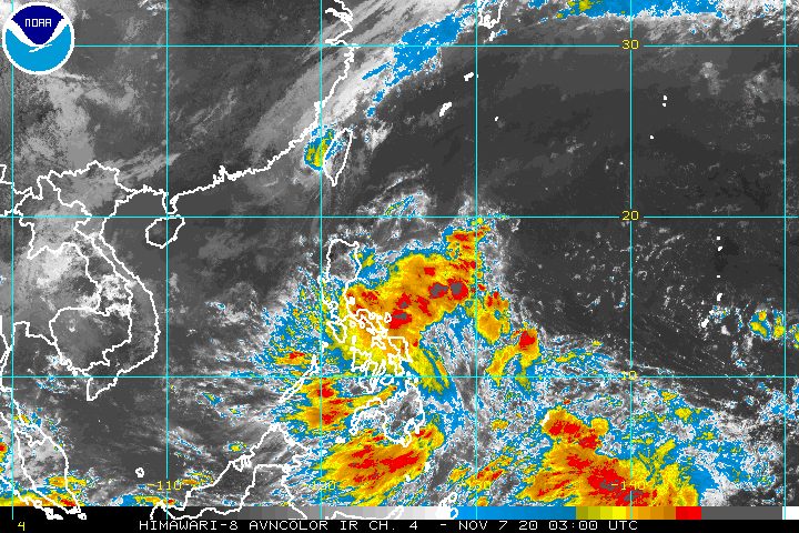
Heavy rain is expected in the region of Bicol and in Samar Island – divided into the provinces of Northern Samar, Eastern Samar, and Samar – on Saturday, November 7, as a low pressure area (LPA) approaches.
In an advisory at 11 am on Saturday, the Philippine Atmospheric, Geophysical, and Astronomical Services Administration (PAGASA) said the LPA is now 205 kilometers east of Guiuan, Eastern Samar.
It continues to move toward the region of Eastern Visayas, of which Samar Island is part of, and may reach the area on Saturday afternoon.
PAGASA warned that the LPA is likely to develop into a tropical depression within 36 hours or during the weekend. This may happen when it is near or already over Philippine landmass. (READ: FAST FACTS: Tropical cyclones, rainfall advisories)
When the LPA becomes a tropical depression, it would be given the local name Tonyo, as the Philippines’ 20th tropical cyclone for 2020.
Signal No. 1 would be immediately raised as well, to warn residents of the impact of tropical cyclone winds.
As of 11 am, PAGASA updated its rainfall forecast for the LPA. Below are the affected areas.
Moderate to heavy rain, with at times intense rain
- Bicol
- Northern Samar
- Eastern Samar
- Samar
Light to moderate rain, with at times heavy rain
- Calabarzon
- Mimaropa
- rest of Visayas
- Mindanao
PAGASA warned that floods and landslides could occur, especially during heavy or prolonged rainfall in high-risk areas and in areas that already received significant rainfall from tropical cyclones Pepito (Saudel), Quinta (Molave), and Rolly (Goni), which all hit Luzon within the past 3 weeks.
Rolly, in particular, pummeled Bicol as a super typhoon and Calabarzon as a typhoon last November 1.
The LPA and the easterlies will also cause moderate to rough seas, with waves 2 to 3.5 meters high, in the following seaboards:
- seaboards of northern Quezon (including the northern and eastern coastal waters of Polillo Island) and Camarines Norte
- northern seaboard of Camarines Sur
- northern and eastern seaboards of Catanduanes
- eastern seaboards of Albay (including Rapu-Rapu Islands), Sorsogon, Eastern Samar, Dinagat Islands, and Siargao Island
PAGASA advised small vessels to take precautionary measures and “inexperienced mariners” to “avoid navigating in these conditions.”
The Philippines has had 19 tropical cyclones in 2020, with the latest one Severe Tropical Storm Siony (Atsani), which hit extreme Northern Luzon and left the Philippine Area of Responsibility (PAR) at 12 am on Saturday.
An average of 20 tropical cyclones form within or enter PAR each year. (READ: LIST: PAGASA’s names for tropical cyclones in 2020)
These are PAGASA’s latest estimates for the number of tropical cyclones inside PAR in the next 6 months:
- November 2020 – 1 to 3
- December 2020 – 2 or 3
- January 2021 – 0 or 1
- February 2021 – 0 or 1
- March 2021 – 0 or 1
- April 2021 – 0 or 1
In early October, the state weather bureau warned Filipinos to expect more rain in the coming months due to the onset of La Niña.
The onset of the northeast monsoon or hanging amihan was also declared on Friday, November 6, which means there will be “surges of cold temperatures.”
PAGASA also said La Niña may enhance the northeast monsoon, which could trigger floods and landslides. – Rappler.com
Add a comment
How does this make you feel?
There are no comments yet. Add your comment to start the conversation.