SUMMARY
This is AI generated summarization, which may have errors. For context, always refer to the full article.
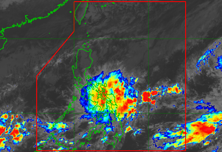
MANILA, Philippines – The shear line and the trough or extension of the low pressure area (LPA) inside the Philippine Area of Responsibility are dumping heavy rain, especially in parts of the Visayas, on Saturday, November 18.
The shear line refers to the point where cold air from the northeast monsoon or amihan converges with warm air from the Pacific Ocean.
The LPA, meanwhile, was located 505 kilometers east of Surigao City, Surigao del Norte, as of Saturday afternoon. It only has a slim chance of developing into a tropical cyclone.
The Philippine Atmospheric, Geophysical, and Astronomical Services Administration (PAGASA) warned of scattered rain showers and thunderstorms in the Visayas, Mimaropa, Bicol, Northern Mindanao, Caraga, and Davao Region, due to the shear line and the LPA’s trough.
Flash floods and landslides are possible during periods of moderate to heavy rain.
So far, rainfall on Saturday has been heaviest in Eastern Visayas and parts of Central Visayas.
ALSO ON RAPPLER
- De Lima’s freedom is vindication for her and a test for Marcos, Duterte
- Marcos gov’t taps TikTok to help small Filipino entrepreneurs
- Phivolcs: Earthquake off Davao Occidental likely generated by Cotabato Trench
- IN NUMBERS: Who are UAAP men’s basketball top scorers so far?
- PH’s Sophia Laforteza to debut with HYBE, Geffen’s girl group KATSEYE
The rest of Luzon may see light rain from the northeast monsoon, but PAGASA said there will be “no significant impact.”
The rest of Mindanao only have localized thunderstorms, not linked to the weather systems being monitored. – Rappler.com
Add a comment
How does this make you feel?
There are no comments yet. Add your comment to start the conversation.