SUMMARY
This is AI generated summarization, which may have errors. For context, always refer to the full article.
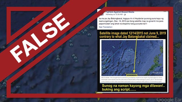
Claim: Maritime law expert Jay Batongbacal used an outdated satellite image to show the areas of the Recto Bank incident on June 9.
The Facebook page Fighters Against Biased Media posted the claim on June 18 with a caption that read: “Isa ka pa Jay Batongbacal, kagaya rin ni [Richard] Heydarian punong puno kayo ng kasinungalingan, Dec. 14, 2015 pa itong satellite map na ginamit mo para papaniwalain ang lahat na eksperto kang punyeta ka!!!!”
(You’re just like the others, Jay Batongbacal. You are like [Richard] Heydarian, you are both full of lies. The satellite map you used to make us believe that you are an expert is dated Dec. 14, 2015, the heck!)
The attached satellite image in the claim was edited with a yellow arrow pointing to a small yellow box which highlighted the imagery date that says “12/14/2015.”
A line of text in the edited photo reads: “the satellite image dated 12/14/15 not June 9, 2019 contrary to what Jay Batongbacal claimed.”
The claim was spotted via CrowdTangle with another Facebook group accumulating almost 600 shares, 400 reactions, and 100 comments.
Rating: FALSE
The facts: While it is true that data used in the Google base map as shown in Batongbacal’s post was captured in 2015, the screenshot in Batongbacal’s post also included a layer from the Visible Infrared Imaging Radiometer Suit (VIIRS) which captures satellite images on Earth in real time.
It’s also worth noting that the imagery date in Google Earth also typically indicates either the date or the range of dates when the map image was taken.
The VIIRS is one of several instruments onboard the Soumi National Polar Partnership satellite flown by the National Aeronautics and Space Administration (NASA) and the National Oceanic and Atmospheric Administration (NOAA). It detects lights sources present on the earth’s surface and can be used for environment and climate monitoring. It is specifically used to detect fires, ice, ocean color, vegetation, clouds, and land and sea surface temperatures.
Besides this, data from the VIIIRS is also used for boat detection by international non-profit organization Global Fishing Watch to detect the activities of vessels in the sea at night.
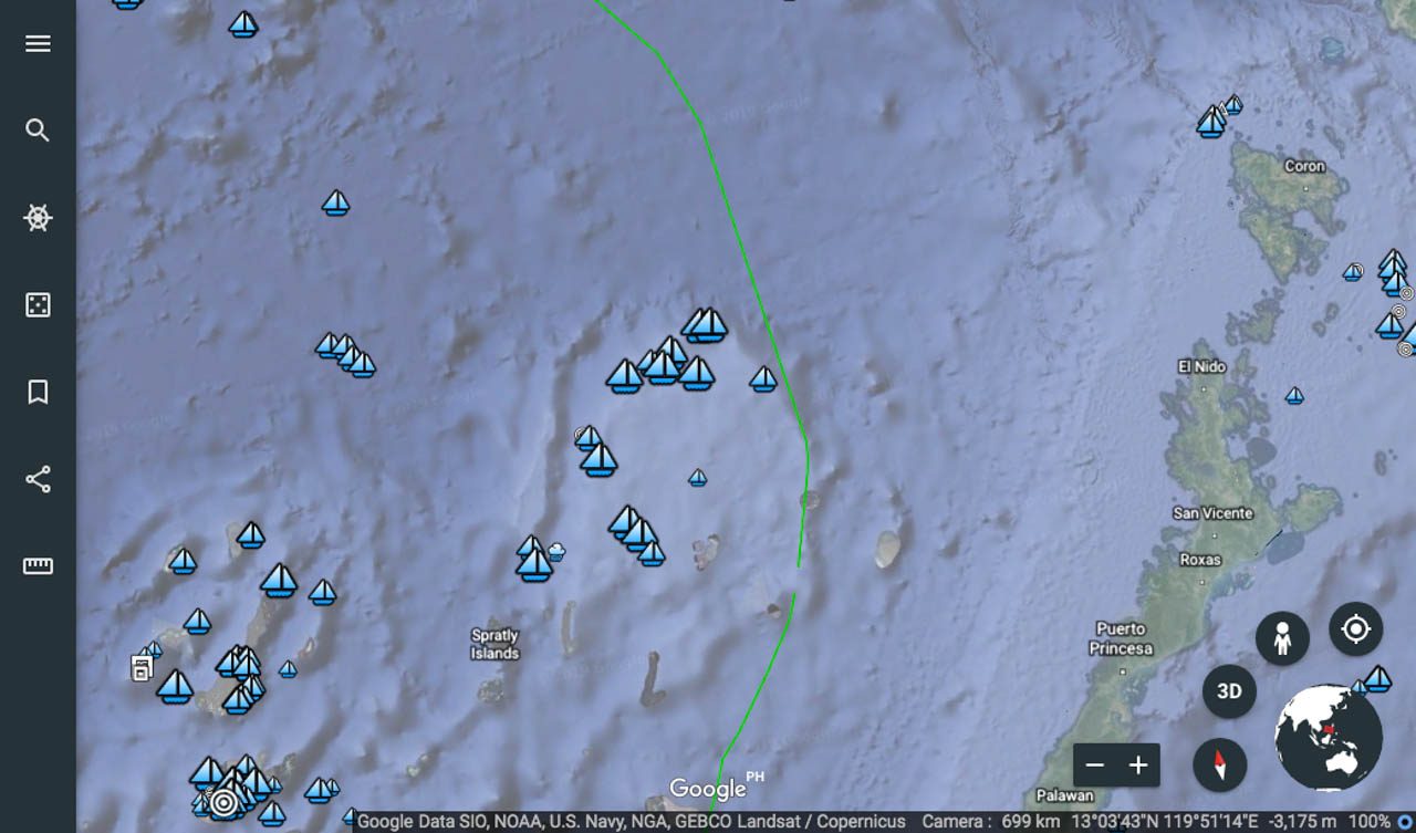
Rappler was able to recreate the map with the layer Batongbacal used by downloading the archived keyhole markup language (kml) file for the corresponding date (June 9) from the VIIRS data repository of the Earth Observation Group. The kml file was then layered on the Google Earth application to show the activities of boats near the Philippine territory on June 9. (READ: Satellite data show China ship not ‘besieged’ by Filipino boats)
The resulting map image was similar to the one that Batongbacal posted as shown below:
Batongbacal used this image to challenge the Chinese embassy when it tried to explain why the Chinese vessel abandoned the Filipino fishermen after the ramming incident. (READ: China omits ‘besieging’ by PH boats in new statement)
He said in his post that there were only a few Filipino fishing vessels that were even “spread over the wide area of Reed Bank.” How could the Chinese vessel possibly be “besieged by 7 to 8 Filipino fishing boats,” as claimed by the embassy? – Glenda Marie Castro/Rappler.com
If you suspect a Facebook page, group, account, a website, or an article is spreading false information, let Rappler know by contacting us at factcheck@rappler.com. Let us battle disinformation one Fact Check at a time.
Add a comment
How does this make you feel?


There are no comments yet. Add your comment to start the conversation.