SUMMARY
This is AI generated summarization, which may have errors. For context, always refer to the full article.
MANILA, Philippines – In 1994, a resplendent Miss Philippines made it to the semifinals of the Miss Universe pageant in Manila. In the Q&A, the host asked that candidate, Charlene Gonzales, exactly how many islands there are in the Philippines.
Gonzales replied with another question: “High tide or low tide?”
That quip drew amused laughter from the audience and became part of the Pinoy pop culture lexicon of the 1990s.
Fact is, it’s rather tricky to count just how many islands comprise the Philippines – especially if we consider how international maritime law defines an “island.” And that was before China became aggressive about claiming some of our islands as theirs, which would have made a beauty pageant audit of our archipelago politically explosive.
But wouldn’t you know it? Whether a scrap of land in the middle of the sea sinks or sticks out of the water during high tide became the crucial question when our government was seeking international arbitration of our dispute with China from 2013 to 2016.
While we usually call all land features surrounded by water “islands,” the United Nations Convention on the Law of the Sea (UNCLOS) sorts them into 3 types: low tide elevations (LTEs), rocks, and islands.
According to these 3 types, UNCLOS identifies what benefits a country gets and doesn’t get from owning them – the concept of “maritime entitlements.”
Low tide elevations
A low tide elevation, as the name implies, only rises above the water’s surface at low tide.
If an “island” sinks into the sea at high tide, then by international law, it’s not really an island; it’s a mere LTE.
If a country owns – or “has sovereignty over” – an LTE, international law affords no maritime entitlements to it. It’s as good as seawater.
Rocks
Suppose your “island” does stay above water even during high tide but isn’t large enough to have the biological ecosystem it takes to support a self-contained human community?
UNCLOS would define it as a “rock.” It’s still technically not an island.
UNCLOS affords the country that has sovereignty over a rock the maritime entitlement to a “territorial sea” of 12 nautical miles around it. The 12 nautical miles of water around your rock is considered your territory.
One nautical mile is about 1,852 meters and 12 nautical miles is approximately the distance from the Rizal Monument in Manila to Bocaue, Bulacan, in a straight line.
A “rock” affords you full ownership of all resources in your territorial sea and the seabed under it, but you also have full political control over it. That is, you get to say who sails in and out of that territorial sea, and you have the legal right to keep foreigners out.
Islands
If your land feature stays above water even at high tide and is large enough that it has trees, animals, perhaps a river or a lake, and basically everything a human community needs to survive on its own, then you’ve got what UNCLOS defines as an “island.”
The country that has sovereignty over that island has maritime entitlements to a 12-nautical-mile territorial sea and a 200-nautical-mile exclusive economic zone (EEZ) in the waters around it.
Two hundred nautical miles is the approximate distance from the Rizal Monument in Manila to Roxas City, Capiz, in a straight line.
If you’re the country that owns a full-fledged island in the way UNCLOS defines it, you get that 12 nautical miles of marine territory around it, and then beyond that up to 200 nautical miles from the shore, you get full, exclusive rights to explore and enjoy all the resources from the water and the seabed under it.
However, UNCLOS requires you to observe “freedom of navigation and overflight” in your EEZ. That is, you must allow foreign vessels to sail through your EEZ and foreign aircraft to fly above it because it’s their right, too, under international law.
But they cannot take anything from the water or the seabed, and neither can they survey what is in those, because you have exclusive, “sovereign rights” over those.
Parts of the sea or the ocean that are beyond 200 nautical miles of any continent or island are considered the “high seas,” and no one may lay any claim of ownership over it.
How it mattered
Both the Philippines and China are signatories to UNCLOS, which means both countries have agreed to observe and abide by it.
UNCLOS uses the system we briefly discussed above to identify any country’s maritime entitlements in the seas around it, and nothing else.
China claims to have “historical rights” to almost the entire South China Sea, including the Philippines’ EEZ that Filipinos call the West Philippine Sea.
The Spratly Islands, or what Filipinos call the Kalayaan Island Group (KIG), are scattered over the western area of the West Philippine Sea.
The Philippines, China, Vietnam, Malaysia, Brunei, and Taiwan are claiming sovereignty over different islands in the KIG.
Supposing those islands come with territorial seas and EEZs, the countries with sovereignty over those islands would then take vast swathes of our EEZ along with them, not to mention the epic headache of sorting out overlaps owing to those “islands” being relatively near one another.
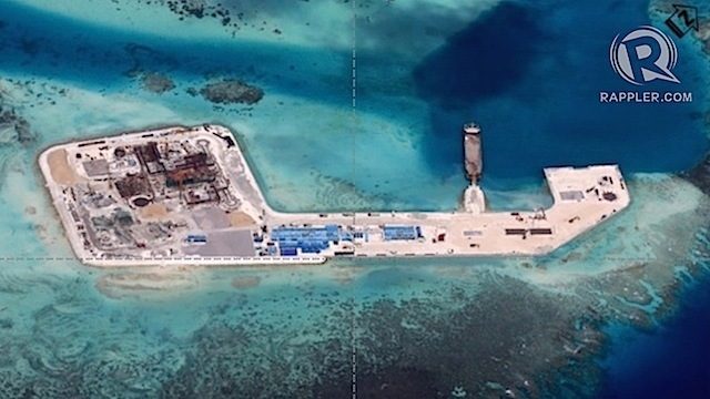
China obviously claims ownership or sovereignty over all of them, and even reclaimed 7 of them, making them into artificial islands with military installations.
Imagine if China laid claim to territorial seas and EEZs around those so-called islands. The Philippines would practically be left with just our western seashores and not much else.
Here then lay the Philippine government’s legal game: What if those “islands” were not really islands in the UNCLOS sense? Many of them disappear into the water at high tide. What if they were merely LTEs or rocks with no EEZ? Then it wouldn’t really matter who owned them; they would all fall within the Philippines’ EEZ that is reckoned from the Luzon and Palawan coastlines, which are undisputedly ours.
Those reefs and shoals matter little in light of the bigger picture of the West Philippine Sea. The oil and natural gas reserves believed to be worth billions, even trillions of pesos, are all tucked under its broad seabed.
The nourishing, life-giving, income-generating marine biodiversity is in its rich waters.
When the Philippines stood before the UNCLOS arbitral tribunal, it did not seek a verdict on sovereignty – only the International Court of Justice has the authority to do that and the Philippines could not bring the case there without China’s participation.
What the Philippines asked the UNCLOS tribunal was merely to define the nature of the land features in the West Philippine Sea to clarify what maritime entitlements they come with.
And sure enough, on July 12, 2016, the UNCLOS arbitral tribunal in the Hague, the Netherlands, ruled that the land features in the Spratlys or KIG, including the 7 that China turned into artificial islands, were legally not islands at all but mere LTEs and rocks, which at most would afford whichever country that owned them only a territorial sea – tiny holes in the vast expanse of the Philippines’ EEZ, the West Philippine Sea.
The tribunal affirmed this EEZ, reckoned from the Philippines’ westernmost coastlines in Luzon and Palawan.
The tribunal further ruled that China’s purported historical claim, the 9-dash line, had no basis in UNCLOS and was therefore illegitimate.
And that was how the Philippine government then, with a keen reading of international maritime law, was able to use a simple question – high tide or low tide? – to beat China’s game. – Rappler.com
Add a comment
How does this make you feel?
There are no comments yet. Add your comment to start the conversation.