SUMMARY
This is AI generated summarization, which may have errors. For context, always refer to the full article.
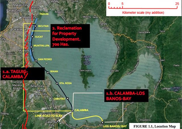
A project to build a “Laguna Lakeshore Expressway Dike” (LLED) east of the shoreline from Bicutan to Los Baños, also meant to protect Metro Manila from lake floods, is very dangerous. Its first phase, from Bicutan to Calamba is proceeding with alarming rapidity. Contracts are to be awarded this April.
The project would also reclaim 700 hectares of the lake bed west of the dike. This is the modified official project map.
If the project is constructed and protects Metro Manila from lake-water floods, people living elsewhere along the lake will suffer, simply because the flood water will have to go somewhere.
Reclamation would reduce the size of the lake, so storms would make higher floods than before.
Real estate interests will profit greatly from the reclaimed land, and people wealthy enough to own cars will enjoy reduced travel time from Bicutan to Los Baños. Bus and jeepney travel times would also be shortened – the only benefit for the poor, who would also bear the greatest costs. Besides worsened flooding along the unprotected lakeshore, reclamation would displace poor people from their lands, homes and livelihood.
If the dike fails, it would be catastrophic.
The greatest hazard posed to it is an earthquake. In 2004, Phivolcs, JICA and MMDA reported that Metro Manila is overdue for a magnitude 7.2 earthquake, which would most likely be generated at the West Marikina Valley (WMV) Fault.
The entire 2 to 3-kilometer wide strip of land adjacent to the lakeshore, the WMV fault zone, would experience Intensity 9 on the Phivolcs Earthquake Intensity Scale:
“Devastating – People are forcibly thrown to ground… Most buildings are totally damaged. Bridges and elevated concrete structures are toppled or destroyed…. Water sewer pipes are bent, twisted or broken. Landslides and liquefaction …are widespread. The ground is distorted into undulations… Boulders are commonly thrown out. River water splashes violently or slops over dikes and banks.”
This threat is being taken very seriously by both government and private agencies. Why they entertain the LLED project at the same time is very troublesome.
The WMV Fault was carefully analyzed by Dr Rolly Rimando of Phivolcs and Dr Peter Knuepfer of the State University of New York. After peer review, their study was published in the international journal Tectonophysics in 2006. I have superimposed their map of the fault segments as red lines on the DPWH project map above.
Note that from Bicutan to Muntinlupa the expressway-dike runs parallel to, and less than two kilometers east of fault segments. Nature does not casually make parallel features; we can reasonably assume that the western lakeshore is related to the fault. If a large earthquake on the WMV Fault ruptures the dike, Metro Manila would be flooded catastrophically, especially if it occurred with the lake at its highest level.
Even if the dam were not already built when the earthquake occurs, and even if it happens during the dry season, the lake water would respond by sloshing back and forth between the western and eastern shores of the West Bay, as a series of “standing waves” or “seiches” (pronounced “seyshes”). You can model this by suddenly disturbing one side of a washbasin partly filled with water.
During and after the earthquake, seiches would overtop the western shore and inundate Metro Manila several times every 10 minutes or so, like a series of tsunamis. Their heights would depend on the lake depth and the vertical motion generated by the earthquake. If the expressway dike was already in place and had raised the lake level, the overtopping flows would be greater, and would succeed each other more quickly.
The worst-case scenario, of course, would be if the lake level was high during the rainy season, the dike ruptured at the same time that a seiche arrives, and it happened at night.
Reclamation areas even closer to the fault zone are underlain by thick, water-saturated sediments. Any structures built there would experience catastrophic damage during a major WMV Fault earthquake. They would shake more strongly from the earthquake waves than structures sitting on solid rock. You can model this effect easily: Place a glass of water directly on a wooden table, which will represent hard, rigid rock, and another on a common kitchen sponge sitting on the table, which will represent the sediments. Hit the table strongly with your fist; the glass on the wood will shiver, but the water in the glass on the sponge will be disturbed much more. This is called “enhanced ground-shaking”.
While the earthquake lasts, its shaking would also transform the sediment and its water content into a liquid-like mixture without strength. Buildings would sink into it or topple.
During my 3 decades of Philippine hazard research, efforts by Rolly Rimando and many other excellent Filipino scientists to mitigate natural disasters have been ignored or contradicted by DPWH, the government agency with the worst reputation for corruption. The elevation to DPWH Secretary Rogelio Singson, a man of unquestioned integrity, was very welcome. The continuing plans for the LLED, however, make it clear that the good Secretary still has a huge housecleaning job to do.
Indeed, as of last November, DPWH is still advocating wholesale reclamation of nearshore Manila Bay, as this map from the agency shows.

In 2014, Philippine Science Letters published my scientific analysis of the natural hazards that threaten Manila Bay reclamations. In it, I invited reclamation proponents to rebut its facts and analyses. They have not; instead, DPWH is proposing to greatly expand reclamation from the Metro Manila coast all the way to Bataan.
Sec. Singson might ask Filipino geologists familiar with Laguna de Bay what they think about the project: Dr Fernando Siringan, Director of UP Diliman’s Marine Science Institute (MSI) (the National Academy of Science and Technology’s only geologist), and Dr Caroline Jaraula, also at MSI.
And have Dr Rimando and other Phivolcs scientists evaluated the hazards facing these projects? – Rappler.com
 Kelvin Rodolfo is Professor Emeritus of Earth and Environmental Sciences at the University of Illinois at Chicago, and Senior Research Fellow at Manila Observatory. He studied lahars at Mayon Volcano in the 1980s and educated the Filipino public about lahars with his work during and after the 1991 Pinatubo eruption. He and Dr Fernando Siringan discovered and described land subsidence and its consequences in Central Luzon and Metro Manila; in 2010, both were the first geologists elected to the National Academy of Science and Technology.
Add a comment
How does this make you feel?
There are no comments yet. Add your comment to start the conversation.