SUMMARY
This is AI generated summarization, which may have errors. For context, always refer to the full article.
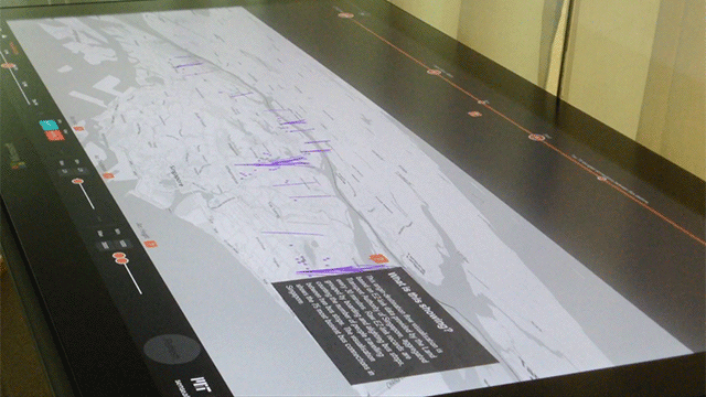
SINGAPORE – A sea of blue, red, and orange dots covered a map of Singapore on one of six touchscreen monitors inside the Senseable City Lab, a research laboratory within the University Town complex of the National University of Singapore.
These dots represent a “heat map” of rainfall distribution in Singapore on a particular date, says big data software engineer Ramprasad Sivaprakasam. The redder the dot, the more rain fell on the area, he explains.
“The coolest thing about this, is it’s all in 3D,” he then says as he swipes the map up to show the 3D effect: the dots are now forming a wavy blanket on top of the city-state’s map.
Sivaprakasam is showing just one of various visualizations that can be produced by the Data Collider, a visualization tool that, he says, promises to take a user from a raw dataset to a visualization within 15 minutes.

It is mainly used as a tool to visualize data on transportation, weather, and communications, part of the research being done by the Future Urban Mobility group of the Singapore-MIT Alliance for Research and Technology (SMART).
Formed in 2007 by a partnership between the Massachusetts Institute of Technology (MIT) and the Singapore government’s National Research Foundation (NRF), SMART aims to “identify and carry out research on critical problems of societal significance and develop innovative solutions” through interdisciplinary projects.
SMART’s projects are divided into five interdisciplinary research groups, or IRGs, of which the Future Urban Mobility group (usually called the FM group) is one. Each group consists of researchers, called investigators, from both MIT and Singapore; some are postdoctoral or graduate students, some are faculty members, all led by a faculty member from the MIT.
The other IRGs are the BioSystems and Micromechanics group, focused on “bridging the gap” between engineering and biology; the Infectious Diseases group; Low Energy Electronic Systems group; and the Center for Environmental Sensing and Modeling group, working on environmental modeling.
“The goal of the FM is develop new paradigms for the planning, design, and operation of future mobility systems,” said Dr Zuo Bingran, the IRG’s program manager.
An international ‘collaboratory’
SMART is part of the Campus for Research Excellence and Technological Enterprise (CREATE), a group of research centers formed by tie-ups between some of the world’s top universities with local ones.
They call themselves a “collaboratory” – an interdisciplinary playground of ideas, where engineers, doctors, scientists, academics and students work together on projects that aim to benefit Singapore, and eventually, the rest of the world.
SMART and 9 other CREATE centers are housed in the CREATE complex, an award-winning structure of glass and concrete punctuated by greenery at regular intervals.
The 9 other centers are collaborations with some of the universities in Europe, Middle East, China, and the United States, working on four thematic areas of research at the core of CREATE’s agenda: human systems, environmental systems, energy systems, and urban systems. These projects are central to the growth of Singapore.
Some centers work on sustainable design and planning of cities (Singapore-ETH Centre for Global Environmental Sustainability, in partnership with ETH-Zurich), while some work on nanotechnology for use in water and energy management (the NTU-Ben Gurion University-Hebrew University of Jerusalem center). Others work on carbon-related technologies, while some study electromobility, or finding more energy-efficient ways to run transport (TUM-CREATE center).

As their research agendas are based on strategic areas identified by the Singapore government, the different research groups and centers also work with each other on various levels. In SMART, for example, the projects overlap; a group working on autonomous vehicles can also work with a group developing car-sharing models, as well as those working on commuter behavior.
Its location, part of the NUS University Town, is strategic; the area, aside from sitting within the country’s premier university, is also home to numerous R&D centers, such as the Biopolis-Fusionopolis-Mediapolis complex, the Singapore Science Park, the National University Hospital complex, and other educational institutions.
The FM group works on projects that could help a city like Singapore adapt to the future of transport and mobility.
The group’s work is divided on three pillars, said Zuo:
- The Networked Computing and Control pillar, where investigators work on developing software and algorithms that can be used for various urban mobility systems, such as data visualization software or communication systems for autonomous – or “driverless” – vehicles;
- The integrated modeling pillar, where researchers work on tools that can be used for analyzing transport demand, performance and optimization, taking into consideration the different aspects of mobility in an urban environment; and
- The performance assessment and implementation pillar, where projects focus on the planning aspect of urban mobility, like behavior models for future land use, or real-time traffic management systems using smartphones.
LIVE! Singapore falls under the NCC pillar. “Live Singapore is a platform where we can analyze or visualize different kinds of data from different sources, to better understand what’s going on in the city,” Zuo said.
The Data Collider is part of the said project. It has its beginnings on a visualization that showed the passenger volume on bus routes using data from the ez-link farecards used by commuters to pay for their fare.
Urban problems, high-tech tools
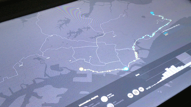
On another touchscreen monitor, Sivaprakasam shows another map of Singapore, this time crisscrossed by squiggly lines, representing several bus routes. He selects the route of Bus Number 10, the longest bus route on the island, and blue and orange circles of varying sizes line up on the bus’s path.
In Singapore, passengers use the ez-link card to pay fares on buses or trains by tapping in their cards at the card reader at the start of the trip, and then tapping out once they alight.

Little city, big science
We take the pulse of the city-state’s science and technology community, through some of its prominent institutions and centers, to see how far the country has come in terms of R&D – and what lies ahead
“The blue colored circles are the tap-outs, and the orange colored circles are the tap-ins,” he explains, as the circles begin to change shape when the tool was put in time-lapse mode. “It shows the variation of ez-link tap-ins and tap-outs over time.”
These visualizations are seen to be an important tool in analyzing mobility patterns in cities such as Singapore. Before the lab developed the visualization tool, the tap-in and tap-out data, collected by the Land Transportation Authority (LTA), was not fully utilized. The data collected turned out to be a treasure trove of information that can be used to analyze commuting behavior and trends.
Singapore is a good place for research in urban mobility, primarily because of the challenges it faces as a city-state, Zuo says. Rapid growth of the economy and population creates numerous challenges in transportation, environment, and living spaces. It also helps that there are a lot of data sources that can be used to study these issues.
The key, however, to fully utilize these data sources to analyze a city’s problems and look for potential solutions is an interdisciplinary approach.
“You need an interdisciplinary research group, you need different expertise to serve the challenges of an urban environment from different angles,” Zuo says. – Rappler.com
Other stories in this series
Lowly microbes, high-tech research | A Singapore-based research institution is studying how the lowly biofilm can make an impact on environmental and public health issues | Read more >>
Innovating for the Asian consumer | Singapore’s research and development program draws global giants that want to reach the Asian consumer | Read more >>
Graphics by Jessica Lazaro
Add a comment
How does this make you feel?
There are no comments yet. Add your comment to start the conversation.