SUMMARY
This is AI generated summarization, which may have errors. For context, always refer to the full article.

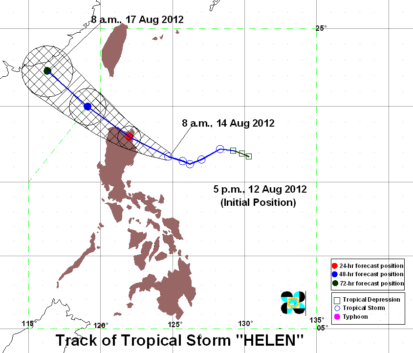
MANILA, Philippines (UPDATED) – More areas are under public storm warning signals as Tropical Storm “Helen” (international codename Kai-tak) intensified in the afternoon and is still on course towards northern Luzon.
As of weather bureau Pagasa’s 5 pm severe weather bulletin on Tuesday, August 14, Helen’s center was last spotted at 230 kilometers east southeast of Tuguegarao City, with maximum sustained winds of 85 km/h near its center and gustiness of up to 100 km/h.
Pagasa forecasts that Helen will continue to move toward the west northwest at 13 km/h and is estimated to be 180 km north of Tuguegarao by Wednesday afternoon.
The following public storm warnings have been raised over the following provinces:
Public storm warning #2:
(61-100 km/h winds expected within 24 hours)
- Isabela
- Cagayan (Including Calayan & Babuyan Islands)
- Apayao
- Kalinga
- Batanes
- Ilocos Norte
- Abra
In these areas, moderate damage to agriculture can occur, particularly to rice and corn; houses with light roofing (nipa/cogon, old galvanized iron) can be unroofed.
Public storm warning #1:
(30-60 km/h winds expected within 24 hours)
- Quirino
- Aurora
- Nueva Vizcaya
- Ifugao
- Mt. Province
- Ilocos Sur
- Benguet
- La Union
The estimated rainfall within the 500 km diameter of the tropical storm is about 20-35 mm per hour, considered intense to torrential.
The bureau warned small seacraft not to venture out to sea in Central & Southern Luzon and the Visayas due to Helen and the Southwest Monsoon.
Landslides and flashfloods are possible in low-lying and mountainous areas under storm signals, the bureau warned. Storm surges and big waves are also expected in areas under signal # 2.
The next bulletin for Helen will be released at 11 pm.
Tuesday’s weather
Helen is expected to enhance the southwest monsoon that will bring rains over Luzon and Visayas, particularly over its western sections.
The rest of Luzon and Western Visayas will have cloudy skies with scattered to widespread rain and thunderstorms, which could trigger landslides and flashfloods, the bureau said.
The remaining areas of Visayas and Mindanao, meanwhile, will be mostly cloudy with scattered rain and thunderstorms.
Moderate to strong winds coming from the southwest will prevail over the rest of the country.
Tuguegarao City will have stormy weather due to the tropical storm, while Laoag City is forecast to have rain and gusty winds.
Metro Manila and the cities of Baguio, Olongapo, Angeles, Tagaytay, Legazpi, Puerto Princesa, Iloilo, and Bacolod are expected to experience cloudy skies with rain and thunderstorms.
Cebu, Tacloban, Cagayan de Oro, Davao, and Zamboanga cities, meanwhile, will have mostly cloudy skies with scattered rain & thunderstorms. – Rappler.com
For more weather updates, visit the #WeatherAlert Microsite.
More in #WeatherAlert:
- 85 dead in floods; over 3-M affected
- Disease alert in aftermath of floods
- P20,000 emergency loan available for affected GSIS members
- Maynilad reduces water supply
- What’s the weather like in your area?
- US pledges P4-M for disaster relief
- LIVE BLOG: August 8 weather and disaster-related updates
- LIVE BLOG: Flood, traffic updates, photos
- Live Blog: Overnight monsoon and flood monitoring, August 8
- A night of fear and rain
- Almost P13M in relief aid distributed
- PHOTOS: PH capital, nearby cities at a standstill in floods
- Filipino values emerge in deluge
Add a comment
How does this make you feel?
There are no comments yet. Add your comment to start the conversation.